Tree, Poison Flat, Carson Iceberg Lake Tahoe to Mount Whitney: Your Backpacking Guide to the High Sierras Yellow Flower
Leavit Peak in December with Snow Plume


The Trails

Guide
Maps
Miles/Ele
Permits
Resupply
Forum


Current Weather Conditions

Weather Notes
Northern High Sierras
Central High Sierras
Southern High Sierras
 

Gear

Gear List
Gettin Started
Layering
Discussion
 
Testing yourself and your gear
 
Gear Reviews


top of page

Backpacker's High Sierra Weather Information

Index and Introduction


Languages

Languages


Trail Arts

The art of walking


Physical Preperation


Trail Skills

The trail
Off the trail
Scrambling
Maps
Navigation
Camp skills
 

Food

Resupply
Food


Other

Photo Catagories
 
Trail Stories
 
Trail Culture
 
News and Science
 
Links
 
Groups
 
Books


Terms and Conditions of Use

top of page

SIERRA WEATHER NORTHERN SIERRA WEATHER CENTRAL SIERRA WEATHER SOUTHERN SIERRA WEATHER LAKE TAHOE WEATHER MAP CARSON PASS WEATHER MAP GEAR all forest-wilderrness maps index

Update: New Information-New Content

UPDATE NOTICE

The whole Weather Section is under Active Construction to provide the best backpacking information for the Deepening Fall Conditions, and the onset of the Winter of 2012: Stay Tuned...

If you've been here before, check it out again. New resources are being added, old assets reorganized, with a whole new presentation. I've started on Oct 10. Give me a couple of days, and Check it out again!

Up to the Minute INFORMATION

The Fall 2011 High Sierra Backpacker Weather, Forecasts, Trail Conditions, and Reports is up and operating for your inspection and information.

High Sierra Weather Section Index and Introduction


High Sierra Weather Information

Organization and Assets

The Sierras are divided into Northern, Central, and Southern weather zones for organizational purposes.

The specific purpose of each of these pages is to allow you to drill down from a "god's eye view," composed of the satellites, radar, and map views of weather on a continentinal scale presented on this page, down to the best local information on specific trail conditions along the Tahoe to Yosemite, the Pacific Crest, and the John Muir Trails as they trace the Sierra Crestline between Lake Tahoe and Mount Whitney.

Each of these weather zones will be (Under Construction) depicted by local USGS maps featuring embedded links to the real time weather reporting stations nearest to the Pacific Crest, Tahoe to Yosemite, Muir, and the other side-trails and loops from Tahoe to Whitney.

Continential to Local Focusing

This page will give you the big picture. Each subsequent weather page will focuses on regional forecasts, local temperture, wind, snow depth, and barometric pressure readings from real time weather stations, and a USGS map showing you the reporting stations in proximity to nearby trails.

Other links will bring you to back up to the broad view of the Satellites, Radar, and Weather Maps from the detailed local forecasts and readings.


Local Weather Resources

NORTHERN SIERRA WEATHER (partial)

CENTRAL SIERRA WEATHER (not done)

SOUTHERN SIERRA WEATHER (not done)


Weather Resources for Backpackers in the Sierra Nevada Mountains

Below, we link to and introduce the "big-picture" weather resources that will show you what's happening far over the horizon as well as above the Sierra Crestline.

Above, we link to the regions of the Sierra Nevada, where you can find regional forecasts, local forecasts, local real-time reporting stations, and local radar resources.


Contiential-Scale Weather Resources

Introduction to Sierra Nevada Weather Big-View High Sierra Weather Resources for the Backpacker

A Season in a Day

The Sierra Crest is noted for having the capacity to produce four seasons of weather during a single Summer Day.

Rain, snow, hail, fog, lightening, and a bit of sunshine can all happen in quick sequence.

Strange Trends

The High Sierras are not just noted for rapid changes in weather and temperature. The High Sierras are also known for sudden appearances of very harsh weather trends. You may experience anything from extended periods of intense heat, bitter cold, Summer snow storms, or tropical-style downpours.

Or you may not. Sierra weather can also be quite placid and delightful. But the Sierra can turn on you in a second, after wearing you out for a week.

This weather page is designed to give you a heads-up about this wild and wide range of weather, and by providing a wide-angle view of current weather conditions from Radar, Satellite, and Maps.

The North, Central, and Southern Sierra pages will have more detailed information, such as real time reporting stations and local forecasts.

Always plan for the historical range of weather possibilities, even if all of the current forecasts, maps, satellites, and ground stations report all is well.

The weather changes quickly in the Sierra Nevada.

Preparation

The Sierra's extremely wide range of weather possibilities must be taken into account, and preparations made to deal with these weather facts BEFORE entering the High Sierras.

The longer your trip lasts, the more likely you are to experience a wide variety of weather conditions, and weather conditions at their extremes.

Recent Times

Long Distance Backpackers who were on the High Sierra Crest in early August of 2009 experienced just such a weather extremety: A Summer Snow Storm.

Temperatures dropped to the high teens and low twenties. Snow and hail fell, which partially obscured the trails. All of those who entertained the misconception that the Sierras only have fine weather during the Summertime were bitterly disappointed, but well corrected.

The many backcountry travelers who were not properly prepared were lucky that little series of Summer storms blew apart, rather than consolidated and deepened. I felt really lucky to get to experience them at all.

Afternoon thunderstorms with prodigious lightening and thunder, occassionally accompanied by a torrential downpour, are regular metrological events on the Western slope of the Sierras to the Crest.

I believe it was during the Summer of 2002 that a two week long trend of torrential downpours between 2pm and Sunset drenched the Sierras, and flooded Tuolumne Meadows, wiping out the water, sanitation, and electrical infrastructures.

Big boulders were rolled onto Highway 120 by the surging flood waters in Tuolumne Meadows.

The results are In

During extremes of climate in the Sierras I have encountered two types of backpackers. There are those who revel in engaging with nature at its unexpected extremes, and those who suffer from these extremes.

The difference boils down to expectations.

Summer Backpackers in the Sierra Nevada Mountains should expect to experience these powerful, but brief wonders, and equip yourselves appropriately.


Weather considerations should guide, if not inform your gear selection.

Big-Picture Weather Checklist for Backcountry Travelers

All Seasons

Regional Radar: Click map for local resources

NWS Western US Satellites

GOES Pacific Ocean Satellites

NWS Weather Maps

 National Weather Service

Radar

National Weather Service Resources

Local, Regional, and National radar resources will show you what is happening right there, right now. Almost real-time loops are available for every map.

Note that the regional-sized radar maps will give you an indication of what is headed towards your hiking area from a great distance away.

Heck, that's the whole point of all the assets on this page!

Satellites

National Weather Service

The NWS Satellite resources page, out of Reno, Nevada will give you an excellent orbital view of upcoming potiential storm activity headed towards the Sierra Nevada, and the Western United States, from far over the horizon.

Combine this information with your use of the NWS Radar, Maps and Forecasts, you can prepare yourself for the nature of the incoming weather.

GOES Pacific Ocean Satellites

The GOES Pacific Ocean Satellites will allow you to track storms coming across the N or S Pacific towards the Sierra Nevada.

Pacific Tropical Satellite Imagery: Northeast Pacific

Maps

National Weather Service

NWS Maps Note: Especially Check the 24 to 48 Hour fronts and Precipitation Maps.

These maps are invaluable projections ofthe movement, development, and interaction of high and low pressure zones, and the movement of their interfaces.

Use the current map to orient the information from the satellites and radar to get a context on all this information so you can project change over the time-span of your hike.

National Weather Service

Home Page

The National Weather Service Home Page displays large and small scale weather warnings which may pertain to your High Sierra backpacking plans.

Other Cool Resources

Federal; REGIONAL SNOW ANALYSES: Western Coastal.

NWS WINTER WEATHER FORECASTS

NATIONAL SNOW AND ICE DATA CENTER

All Sierra Web Cams: Sierra Visions


Check out the High Sierra Backpackers-All Backpackers Forum: TahoetoWhitney.Org

Backpacker Forums

Have a great Sierra Nevada route or trip to relate? Have a backpacking tip or trouble to share?

Post it on TahoetoWhitney.Org

Experiences, comments, or pictures about this topic? Post them up in the Weather Forum:
High Sierra Backpacker Weather Resources
Home Page
Contact Alex Wierbinski

top of page

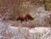
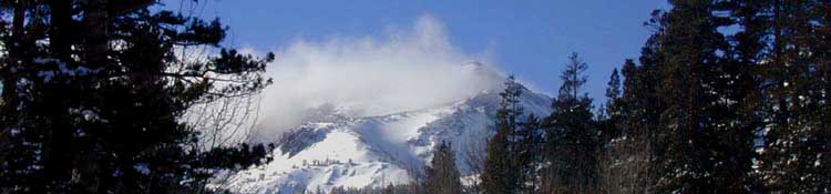
   Below: Meiss Country Winter morning                                                                                            Below:Bear at the Silver King Creek, Carson-Iceberg

Frosted Backpack

Backpacking Lake Tahoe to Mount Whitney: Your guide to the High Sierra Crest, including the Tahoe to Yosemite, Pacific Crest, and John Muir Trails

Bear at Silver King Creek, Carson-Iceberg Wilderness
©Lake Tahoe to Mount Whitney: Crown Jewel of the Pacific Crest Trail