High Sierra
Backpacking
Trail Guide
Forums
Sierra
Weather
Gear
Humboldt-Toiyabe National Forest
Hiker and Backpacker Information
PERMITS
The Pacific Crest Trail through The Eastern Sierra for long distance backpackers
Languages
Trail Skills
Mountain
Safety
Safety
Incidents
Food
Planning
40 Days to Whitney Introduction Tahoe-Yosemite
Trail Arts
More
Information
News
and
Science
Social
| permitting authorities | Lake Tahoe Basin |
El Dorado Permits |
Stanislaus Permits |
Yosemite Permits |
PCT or TYT? |
National Forest list | National Forests map | Toiyabe contacts |
| Sequoia-Kings Canyon National Park |
The
|
| Toiyabe National Forest Links & Contacts |
Page Index | NEW Hoover Wilderness NEW 2015 RESTRICTIONS |
Mountain Safety Issues
Inciweb
Humboldt Toiyabe National Forest
The Toiyabe National Forest administers almost all of the Pacific Crest Trail route hiking South through the whole of the Northern High Sierra from a bit North of Carson Pass until we cross over into Yosemite National Park through Dorothy Lake Pass.
The Toiyabe National Forest administers most of the Eastern flank of the Sierra from the Eastern flank of the Carson Range wrapping around the East shore of Lake Tahoe South to Highway 120. The Toiyabe's administration ends at the bottom of the Hoover Wilderness after wrapping around the North and Northeastern sides of Yosemite National Park in the guise of the Hoover Wilderness.
The Toiyabe National Forest is BIG. Its Western side encompasses most of the East flank of the North Sierra.
Our High Sierra Focus
We are only concerned with a small portion of this vast forest. Specifically we are concerned with the Ranger Districts that administer the portions of the Sierra Crest our Tahoe to Whitney trails cover. The Toiyabe National Forest administers the Eastern flank of the Sierra Nevada Mountains South from the Lake Tahoe Basin down through the bottom end of the Hoover Wilderness to Highway 120.
Two Ranger Districts
This would be the Carson Ranger District covering the East ends of the Mokelumne and Carson Iceberg Wilderness down the Eastern flanks of the Sierra from Highway 88 down to Highway 108, and the Bridgeport Ranger District administering the strip of National Forest on the East flank South from Highway 108 including the whole of the Hoover Wilderness down to Highway 120.
Unlike the Mokelumne and Carson Iceberg Wilderness, which are draped across the Sierra Crest into the El Dorado and Stanislaus National Forests on the Western flank, the Hoover Wilderness remains on the East flank of the Sierra and solely within the scope of the Toiyabe National Forest.
For the most part permits are easy to get in the Toiyabe National Forest. Except for the Hoover Wilderness. The Hoover Wilderness Permit Reservations may be booked up during peak Summer backpacking weekends and weeks. This is because Hoover Wilderness acts as an overflow when Yosemite is highly congested.
Hikers on the Tahoe to Yosemite Trail route will not visit the Toiyabe, as the TYT route stays on the Western flank of the High Sierra.
INDEXOn this page Toiyabe National Forest
Carson Ranger District Mokelumne Wilderness Carson-Iceberg Wilderness
Bridgeport Ranger District Hoover Wilderness Hoover Wilderness Hoover Wilderness
Toiyabe National Forest
Vast Extent of the
Resupply
Pacific Crest Trail
Many Trailheads
Big NF Map: |
Other
Lake Tahoe Basin
El Dorado NF
Stanislaus NF
Humboldt-Toiyabe NF
Yosemite National Park
|
Besides administering the East Flank of the High Sierra from the Lake Tahoe Basin South to Sonora Pass, the Toiyabe National Forest boundary continues South along the Sierra Crest when PCT and TYT routes enter Yosemite.
This means that even though PCT hikers have finally departed the Toiyabe National Forest, it is still off to our East and Northeast, administering the Hoover Wilderness wrapping around the North and Northeast perimeter of Yosemite National Park.
The Toiyabe National Forest directly administers almost all of the trail that the Pacific Crest Trail backpacker will hike across between Lake Tahoe to Yosemite. But here's the deal:
As the Toiyabe is so very large, neighboring National Forests administer the special zones and trailheads on their boundary line with the Toiyabe National Forest. The Carson Pass Management Area is one example. The Southbound PCT almost directly enters the Toiyabe NF administered Mokelumne Wilderness South of Carson Pass.
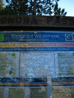
Another example is the Southbound PCT trailhead at Sonora Pass. The PCT tracks the boundary line of the Emigrant Wilderness across the Leavitt Massif, then enters the Toiyabe through Kennedy Canyon South of Leavitt. Yet the Stanislaus NF administers this trailhead.
The Toiyabe administers the whole Eastern Flank of the Northern High Sierra from North of Lake Tahoe to Highway 120 East of Tuolumne Meadows in Yosemite, but not a whole lot of its mountain pass trailheads.
Nonetheless, if we are not in the Toiyabe between Carson Pass down to Yosemite while hiking the PCT, we will be shortly, and we are always looking into the Toiyabe National Forest every time we can look East from anywhere between Carson Pass and Tuolumne Meadows in Yosemite.
The extent of the Toiyabe National Forest is indeed massive.
And they are great folks working for the Forest Service out there. Every time I've called them up, visited the Ranger District Offices, or met their Wilderness Rangers on the trail, I've found that they are the best, most helpful and knowledgeable folks.
Toiyabe National Forest |
||||||||
Main OfficeHumboldt-Toiyabe National ForestSupervisor's Physical OfficeEdward Monnig PHONE: (775) 331-6444
Wilderness
|
RANGER DISTRICTS Permits are obtained from Ranger Districts. Entering the Sierras from the East between Lake Tahoe and Highway 120 will put us into one of these two Ranger Districts, and requires we obtain a permit from either the Carson or Bridgeport Ranger Districts. |
|||||||
|
Carson Ranger District
Eastern flank of the Carson Range around Lake Tahoe then covering the Eastern flank of the Sierra South to just North of Sonora Pass, including the Eastern sections of the Mokelumne and Carson Iceberg Wilderness. Genny Wilson (775) 882-2766 Carson Ranger District Information Bridgeport Ranger District Mike Crawley (760) 932-7070 Winter: Monday through Friday 8:00 am to 4:30 pm Summer: Seven days a week 8:00 am to 4:30 pm Bridgeport Ranger District Information Excellent trailheads to the Sierra Crest Leavitt Pack Station, Highway 108, to Chain of Lakes, Dorothy Pass, or Emigrant Pass.
Carson Pass to Sonora Pass
|
||||||||
Hoover Wilderness ReservationsPermit Applications with instructions, PDF
Hoover Wilderness, Sierra Wild, General Information TOIYABE RESERVATIONS Trailhead Quotas Trailheads Under Quota Contact the Bridgeport Ranger District for more information. Roads, Borders, and Hoover Wilderness Trail MapsRoads and Borders
Virginia Canyon to Tuolumne Meadows
East Sierra Trailheads It shows how we can hike Northwest up Kennedy Canyon from the West West Walker Bridge onto the low gap on the Sierra Crestline at the top of Kennedy Canyon. From there we can hike North, South, East, or West. Or, we can hike Southwest into the Emigrant Basin upriver from the West West Walker Bridge following the West West Walker River to Emigrant Pass. We also have the option of hiking Southeast from the West West Walker Bridge on the Pacific Crest Trail into the North Yosemite Backcountry. We've got some pretty good backpacking options out of Leavitt Meadow. Bensen Lake Loop out of Twin Lakes Trailhead I'm going to fix that as this final edit of the North sections of the guide progress... so bear with me.
The best way to get to Yosemite is to hike there. I would much rather end a trip at Yosemite than begin one there. My preferences for the nearest trailheads I prefer when hiking into Yosemite are Kennedy Meadows Pack Station and Sonora Pass. I would rather walk down from Lake Tahoe, but sometimes we don't have the time or money. Because of the Hoover Wilderness' proximity to Yosemite it too may also experience competition for reservations covering the High Summer Holiday Dates, leading to a shortage of permits during the height of the Summer backpacking season. Contact the Bridgeport Ranger District for more information.
|
||||||||
Toiyabe National Forest
|
|
Federal Online Maps Bottom |
Tahoe to Whitney Topo Hiking Maps |
PDF road, river & boundary map of PDF road, river & boundary map of PDF road, river & boundary map of
Wilderness Backpacking Online PDF Federal Maps |
Mokelumne Wilderness See the Carson Pass to Ebbetts Pass Map for the Pacific Crest Trail route through the Mokelumne Wilderness in the Toiyabe National Forest. ALL Carson Iceberg Wilderness See the Ebbetts Pass to Sonora Pass Map for the Pacific Crest Trail route through the Carson Iceberg Wilderness in the Toiyabe National Forest. |
Toiyabe National Forest
|
|
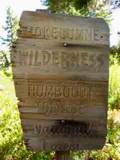
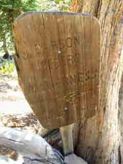
Southbound boundary markers into the Mokelumne, Carson Iceberg, and Emigrant Wilderness in the Toiyabe
Entering the Sierras from the East between Carson Pass to YosemiteThe Toiyabe National ForestThe Toiyabe National Forest is vast. The Toiyabe covers almost all of our route along the Pacific Crest Trail between the Carson Pass South to Yosemite, excepting a couple of small bits. And there is a lot more to the Toiyabe than this. The Eastern entrances to the Carson Iceberg and Emigrant Wilderness are great start points for backpacking trips North to Lake Tahoe or South to Tuolumne Meadows in Yosemite. If we want to enter the Sierras from anywhere East of the Sierra Crest for a local or long distance backpacking trip anywhere South of Lake Tahoe down to Yosemite National Park we've got to get our permits from one of the Toiyabe National Forest Ranger Districts. Below we will figure out which one and its contact information. |
The Big Picture
This Toiyabe National Forest page is mostly concerned with the Pacific Crest Trail as it travels through the Mokelumne, Carson Iceberg, and around the Emigrant Wilderness within the Toiyabe National Forest between the Carson Pass to the Northern boundary of the Yosemite National Park Backcountry at Dorothy Lake Pass. This means that the Toiyabe offers access points hiking West up the Eastern Sierra to the Pacific Crest Trail along the Sierra Crestline. Check the maps above for ideas and I've a whole series of links to the PCT sections that we can divide the trail between Lake Tahoe and Yosemite into on the home page... The Toiyabe NF is massive! If you are interested in hiking the Mokelumne, Carson Iceberg, and Emigrant Wilderness from the West side of the Sierra Crestline, check out the El Dorado and Stanislaus National Forest pages. The El Dorado manages the Western Mokelumne Wilderness while the Stanislaus National Forest administers the Western half of the Carson Iceberg and the totality of the Emigrant Wilderness |
Toiyabe National ForestAdministering the Eastern Sierras through the Carson, Ebbetts, and Sonora Passes to Yosemite |
Grand Context When we backpack South out of the Tahoe Basin on the Pacific Crest Trail through the Carson Gap our view South is of the Mokelumne Wilderness. To the Southeast we are looking into the Toiyabe National Forest administered section of the Mokelumne Wilderness. To the Southwest we are looking into the El Dorado NF administered section of the Mokelumne Wilderness. The Carson Gap is where the Pacific Crest Trail breaks off from the Tahoe to Yosemite Trail to head Southeast towards Ebbetts Pass along the Eastern flank of the Sierras within the Mokelumne administered by the Toiyabe National Forest. The Tahoe to Yosemite Trail tracks Southwest to Lake Alpine along the Western flank of the Sierras Through the Mokelumne Wilderness administered by the El Dorado National Forest. South of Ebbetts Pass Though the Mokelumne Wilderness ends just North of Ebbetts Pass the Southbound backpacker on the Pacific Crest Trail remains in the Toiyabe National Forest as we cross Highway 4 hiking into and across the Carson Iceberg Wilderness to Sonora Pass. As with the Mokelumne Wilderness North of Highway 4, the Toiyabe administers the Eastern portion of the Carson Iceberg Wilderness south of Highway 4 while the Stanislaus National Forest administers its Western half. North of Highway 4 the Toiyabe shares its administration of the Eastern flank of the Mokelumne Wilderness with the El Dorado National Forest's authority over its Western flank. South of Sonora Pass The Toiyabe National Forest wraps around the Eastern Boundary of Emigrant Wilderness South of Sonora Pass, South of Emigrant Wilderness it continues to make up the Eastern flank of the as the Hoover Wilderness. The Toiyabe extends South almost down to Highway 120, the Tioga Road. South of Sonora Pass the Toiyabe officially administers small bits the Pacific Crest Trail as the trail moves back and forth across its Easternmost Boundary as it winds through the mountaintops poking out like a pin cushion on the Leavitt Peak Massif. Though the Southbound Pacific Crest trailhead at Sonora Pass is within, and posted by, the Stanislaus National Forest, the Pacific Crest Trail route South along the Sierra Crest crossing Leavitt Peak wobbles back and forth bouncing between the edges of the Stanislaus and Toiyabe National Forests sharing the Sierra Crestline. After descending the Southern flank of Leavitt Peak the PCT turns East down Kennedy Canyon into the Toiyabe National Forest and remains within the Toiyabe South until entering Yosemite National Park through Dorothy Lake Pass. It Follows Us South... The Toiyabe administers the East flank of the Sierra South of our entrance into Yosemite as the Hoover Wilderness almost all the way down to Highway 120, the Tioga Road. Vast Extent of the Toiyabe National Forest The Toiyabe National Forest is vast. It extends all the way down the Eastern Flank of the High Sierra from the East flank of the Carson Range wrapping around the Eastern shore of Lake Tahoe South through Carson Pass, Ebbetts. and Sonora Passes, then moves a bit East to make up the Eastern boundary of both the Emigrant Wilderness and the whole North Yosemite Backcountry. Virtually all of our entrances into the Sierra from the East Flank between Tahoe and Tuolumne Meadows will require a permit from either the Carson or Bridgeport Ranger Districts of the Toiyabe National Forest. A Northbound hiker on the Pacific Crest Trail will essentially remain within the Toiyabe National Forest from their Northern exit from Yosemite through Dorothy Lake Pass until they hike North through Carson Pass to enter the Lake Tahoe Basin Management Unit. |
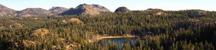
Toiyabe National Forest Resupply |
|
There are two resupply possibilities for long distance hikers on the Pacific Crest Trail within reasonable distance of the Toiyabe National Forest between Yosemite and Lake Tahoe The Southernmost is Kennedy Meadows located a mile off Highway 108 nine miles West of Sonora Pass. The middle resupply is the Lake Alpine Lodge located fifteen miles West of Ebbetts Pass on Highway 4. 15 miles North from exiting the Toiyabe at Carson Pass we resupply at Echo Chalet. To the South of the Toiyabe NF our next resupply spot is the Post Office and Store at Tuolumne Meadows in Yosemite National Park. |
Resupply Spots between Tahoe and Yosemite
|
| last page:El Dorado NF | permitting authorities index | all NF/Wilderness list | next page:Stanislaus NF |
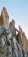
Kennedy Canyon/Big Sam Trail Junction
 |
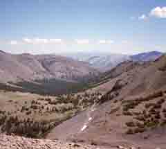 |
| the trail junction where the PCT splits East down Kennedy Canyon into the Toiyabe NF towards Dorothy Pass, and the Tahoe-Yosemite heads over Big Sam towards Bond Pass | looking back and down at Kennedy Canyon where the PCT heads East into Toiyabe NF, while hiking South up Big Sam to the Emigrant Basin. I will rejoin the PCT below Bond Pass, but I am going to enjoy the Emigrant Wilderness in the Stanislaus National Forest, first. |
Let's Take an even closer Look at this Junction!
| Viewing the Trail Junction where the PCT heads down Kennedy Canyon, and our custom route climbs over Big Sam into the High Emigrant Basin. Viewed from the South Flank of Leavitt Peak. | ||
| From here you can see trail options into the High Emigrant Basin as well as the PCT route around it. |
The Tahoe to Yosemite Trail Hiker: No Toiyabe for You!The Tahoe to Yosemite backpacker will not enter the Toiyabe National Forest at all, but pass through the Western parts of the Mokelumne and the Carson Iceberg Wildernesses South of Lake Tahoe that are administered by the El Dorado and Stanislaus National Forests, respectively. The TY Trail runs through the High Emigrant to Bond Pass, and does not dip into the Toiyabe before entering Yosemite as the Pacific Crest Trail does. |
| El Dorado NF | permitting authorities | all NF/Wilderness list | Stanislaus NF |
Jump InsEastern access to the High Sierras is spectacular and remote. The steep Eastern escarpment does not look anything like the Western Slope's forty miles of gently rolling rise from the Totally Flat Big Valley. The Western Flank rises gently upward through the rolling foothills which eventually transitions into steeply rising high ridges, finally terminating at the precipitous lava-bathed granite pinnacles of the Sierra Crest. The Eastern Escarpment of the Sierras is quite different. The Eastern escarpment of the Sierra Nevada rises almost 5000 feet vertically out of the 5000 foot elevation valley that marks the Eastern limit of the range. Yes! Brutal, but beautiful. Highway 395 traces the Eastern boundary of the High Sierras from the Kingsbury Grade, East of Lake Tahoe on the Carson Range spur of the Sierra, all the way down to, and past Lone Pine, which is the town at the base of Mount Whitney. It is an amazing road that is worth a trip to explore, if you've never driven it before. Almost all of the trails entering the Sierra from the East between Tahoe and Lee Vining are administered by the Toiyabe National Forest. My favorite places to Jump Into the Toiyabe NF for extended backpacking trips are through the Little Antelope Pack Station (n. of Walker. Trip: cross the Silver King Creek to the E Carson River up to Sonora Pass, and down the PCT to TM). Another is into the Emigrant Wilderness through Leavitt Pack Station, Highway 108, (summer) or through the Marine Base (winter). Twin Lakes to Tuolumne Meadows is also an excellent backpacking trip out of Eastern Sierras. (Bridgeport, Twin Lakes, to Kerrick Canyon & the PCT, to TM).
|
High Sierra National Forests, Parks, and Wilderness Areas
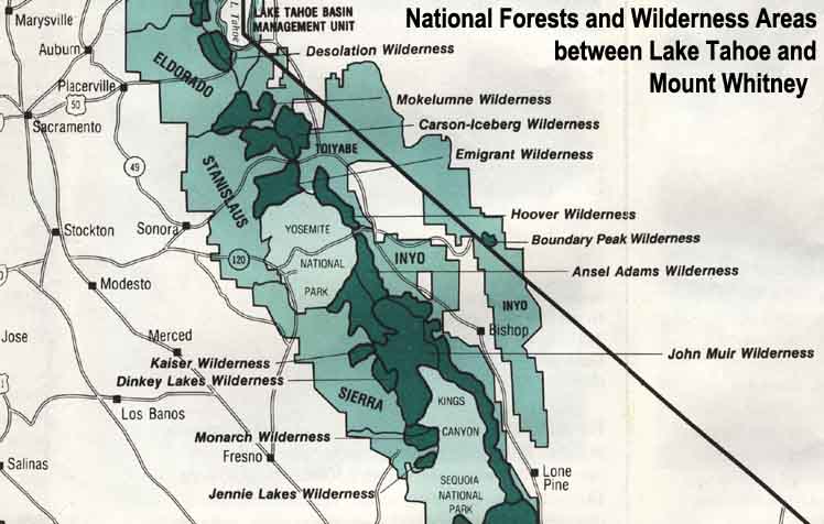 |
| Map Credit: Forest Service, Pacific Southwest Region, "A Guide to National Forest Wilderness in California." |
Large High Sierra
National Forest Map
Our guide to the Sierra Crest, including the Tahoe to Yosemite, the Pacific Crest and the John Muir Trails