

Dicks Lake
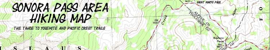
Sonora Pass Region Topo Hiking Map
Backpacking
Tahoe to Yosemite and Pacific Crest Trails
North and South
of
Highway 108
A Classic 30 minute USGS Backpacking Map
| NORTHBOUND | SOUTHBOUND | GUIDE | SUPPORT | |||||||||||||||||||||||||||
| NORTH TYT |
NORTH PCT |
SOUTH TYT |
SOUTH PCT |
|||||||||||||||||||||||||||
| Tahoe to Yosemite NORTH Carson Iceberg Wilderness |
Pacific Crest NORTH Carson Iceberg Wilderness |
Tahoe to Yosemite SOUTH Emigrant Wilderness |
Pacific Crest SOUTH Emigrant Wilderness |
TRAIL GUIDE PAGES |
Permits, Resupply, Weather, and Map Data | |||||||||||||||||||||||||
North |
North TYT SECTION MAP Lake Alpine to Saint Marys Pass |
North |
TYT Miles and Elevations Lake Alpine to Saint Marys Pass |
TYT-PCT GUIDE NORTH MASTER INDEX Highway 4 to Highway 108 |
North |
NORTH PCT SECTION MAP Ebbetts Pass to Sonora Pass |
NORTH PCT 7.5 Minute Map Boulder Lake to Sonora Pass |
PCT Miles and Elevations Ebbetts Pass to Sonora Pass |
PCT-TYT GUIDE NORTH MASTER INDEX Highway 4 to Highway 108 |
South |
30 Min Below |
SOUTH |
SOUTH |
SOUTH TYT-PCT SECTION INDEX Highway 108 to Tuolumne Meadows |
PCT 30 Min SOUTH MAP Sonora Pass to Bensen Lake |
PCT |
SOUTH MILES & ELEVATIONS Sonora Pass to Tuolumne Meadows |
PCT |
PERMITS Stanislaus National Forest |
RESUPPLY Lake Alpine |
WEATHER Sonora Pass |
|||||||||
| Toiyabe National Forest |
||||||||||||||||||||||||||||||
| NORTH TYT |
NORTH PCT |
SOUTH TYT |
SOUTH PCT |
PAGES | SUPPORT | |||||||||||||||||||||||||
| Click the BLACK DOTS for Detailed Maps |
Click the RED DOTS for Trail Guide Informatin |
| PCT topo MAP NORTH Boulder Lake to Sonora Pass |
TYT topo MAP NORTH Clarks Fork to Saint Marys Pass |
PCT to TYT Topo Map WEST to TYT Down Kennedy Creek |
PCT to TYT Topo Map SOUTH to TYT Big Sam to Emigrant Meadow |
PCT topo
MAP SOUTH Kennedy Canyon to Bond Pass |
PCT map South: Sonora Pass to Kennedy Canyon PCT map South: Sonora Pass to Bensen Lake TYT map South: Kennedy Meadows to Relief Reservoir PCT map South: Sonora Pass to Bensen Lake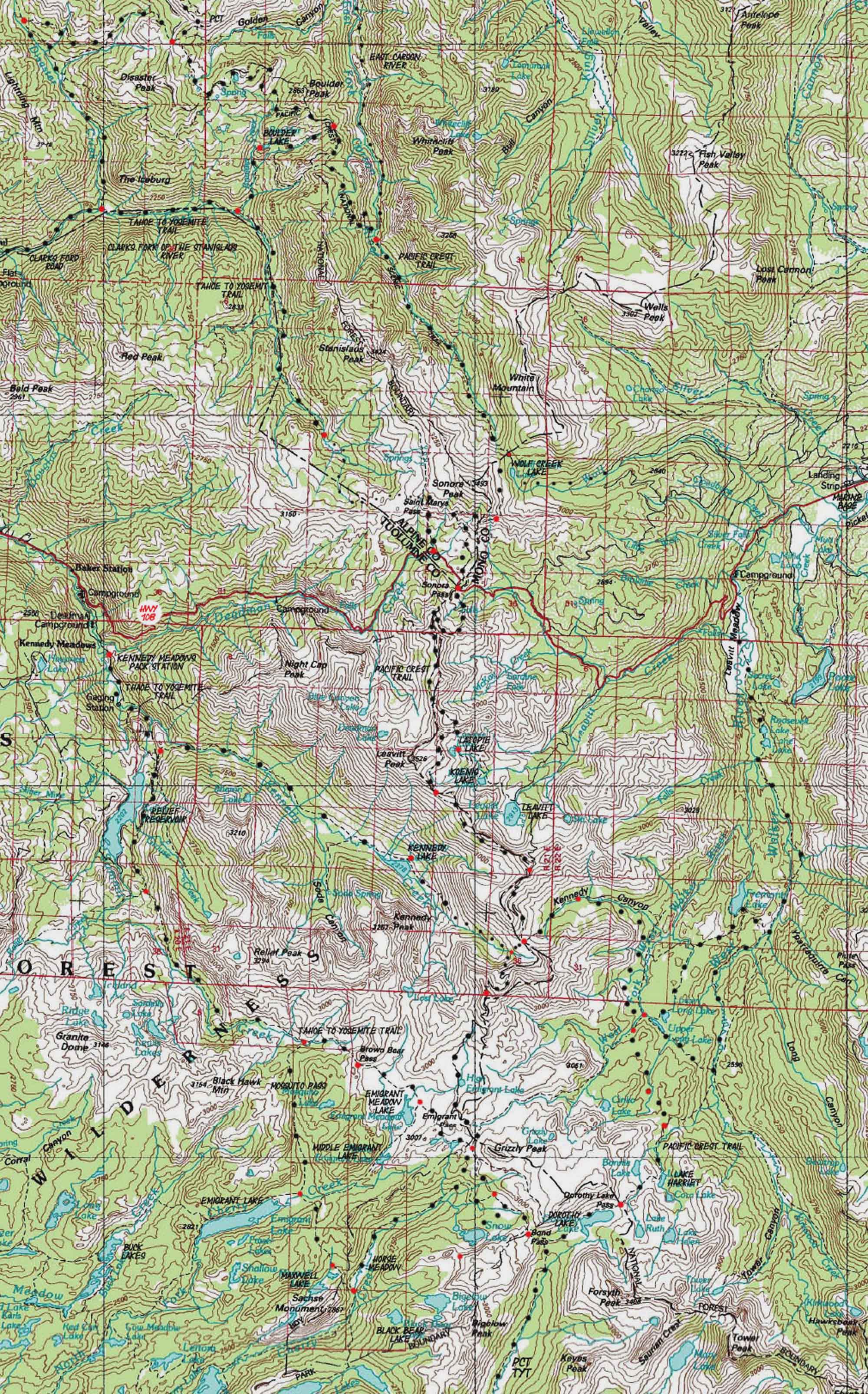
PCT map North: Boulder Lake Jnct to Sonora Pass TYT map North: Boulder Creek to Sonora Pass TYT map South: Kennedy Meadows to Sheep Camp PCT map South: Sonora Pass to Bensen Lake
Mapology |
||||
MAP NOTE What's important for our general reference purpose is that each side of a square is 1000 meters, or a Kilometer. From my point of view that is 1093.6 yards or .62 of a mile. Diagonal: 1414.22 meters, if my trig is correct. That converts the diagonal distance into 4,639.8 feet or .88 of a mile.
|
Saint Marys and Sonora Passes along the top of Highway 108 |
Main Features Local Backpacking Trips from Highway 108 This Map can withstand some magnification, so blow it up!Sonora PassSonora Pass is a significant break in the Long Trails between Lake Tahoe and Tuolumne Meadows. Southbound Sonora Pass is a crossroads of trails, with the Saint Marys Pass Northbound Trailhead of the Tahoe to Yosemite Trail situated about a mile West of Sonora Pass. Hikers South on the TYT can hike the mile East up Highway 108 to switch over to hike the Pacific Crest Trail route South into Emigrant Wilderness through Sonora Pass. Otherwise TYT hikers gotta hitch-hike down to Kennedy Meadows Pack Station to continue South on the Tahoe to Yosemite Trail. But that is a pleasure, as Kennedy Meadows is one of my favorite rest and resupply spots between Tahoe and Whitney, as well as a vital resupply spot for all long distance High Sierra Backpackers. It's value for long distance backpackers is that it accepts UPS resupply shipments for long distance backpackers. I would not walk Highway 108 down to Kennedy Meadows. This a a very narrow, very twisting road around steep and deep corners with a range of Summertime tourists that make walking down downright dangerous. I'm split on which is the "best" route South, the PCT or the TYT. Both are stunning, but in different ways and for different reasons. I suggest hiking both the Summit Creek route South from Kennedy Meadows Pack Station on the TYT and the PCT route over Leavitt Peak into both the Emigrant Basin and the West Walker River drainage. Though the PCT enters the Emigrant Wilderness South of Sonora Pass, it defines its Easternmost boundary across Leavitt Peak. As soon as we drop down off the South flank of Leavitt the PCT turns East out of Emigrant Wilderness down Kennedy Canyon into the Toiyabe National Forest to trace a route around the Sierra Crest across the High Emigrant Basin. That's a good thing; routing the PCT around the High Emigrant keeps it much quieter up there. Hikers can continue South from the top of Kennedy Canyon over Big Sam to join the Tahoe to Yosemite Trail at the trail junction under the West flank of Grizzly Peak. Independent of which route we take, they all end up joining together at the top of Jack Main Canyon in the Northwestern corner of Yosemite National Park. Each route South across (or around-in the case of the PCT) Emigrant Wilderness is stunning. Backpacking Loops and Arcs South of Sonora Pass The map above is designed to stimulate you to craft great Southbound loops from and back to one trailhead along Highway 108, or from one trailhead to another, such as hiking from Kennedy Meadows Pack Station to Sonora Pass. There are three good ways to cook that goose. This can be executed quickly, via Kennedy Lake to the PCT at the top of Kennedy Canyon, finishing the trip by hiking South over Leavitt Peak to Sonora Pass. This route can be extended via Relief Reservoir, Brown Bear Pass, and Big Sam to Leavitt Peak and out at Sonora Pass. This concept can be taken a step further, and your hiking loop extended to a greater circumference by hiking from Brown Bear Pass over to Bond Pass. From Bond Pass a mostly downhill hike Northeast brings around the West Walker River drainage where we can exit through Leavitt Meadow down on the Eastern Flank of the Sierra Nevada, or continue North along the PCT route to Sonora Pass. Backpacking trips Southbound from Highway 108 can provide years of excellent trips bouncing between and around the Kennedy Meadows, Sonora Pass, Leavitt Lake, and Leavitt Meadow Trailheads. Northbound PCT Northbound hikers on the Pacific Crest Trail almost always resupply at Kennedy Meadows. This is because Kennedy Meadows almost perfectly splits the roughly 150 mile distance between Tuolumne Meadows and Lake Tahoe. I strongly suggest resupplying at Kennedy Meadows as opposed to Bridgeport. Northbound hikers also have the option of hiking into Kennedy Meadows by following the Tahoe to Yosemite route North through Bond Pass from the top of Jack Main Canyon crossing the Emigrant Basin to Brown Bear Pass to follow Summit Creek down to Kennedy Meadows. Easy money. Once you reach Brown Bear Pass you will drop like a bomb down to KM. But then you would miss the West Walker and Leavitt Peak along the PCT route... I like to think that I never miss anything, but just find new hikes to explore tomorrow. Both the TYT and PCT routes North to Kennedy Meadows and Sonora Pass respectively, from the top of Jack Main Canyon, are awesome. Backpacking Loops North of Sonora Pass The routes of the Pacific Crest and Tahoe to Yosemite Trails North of Sonora Pass have two nice connector trails located along Disaster and Boulder Creeks. These connecting trails mean you can hike great backpacking loops tying together segments of the TYT and PCT North of Sonora Pass in the Carson Iceberg Wilderness, just as you can do in the Emigrant Wilderness to the South of Sonora Pass. We can hike North out of Sonora Pass along the Pacific Crest Trail to either the Boulder Lake or Disaster Creek connector trails to turn Southwest towards the Tahoe to Yosemite Trail. There is only one problem with this backpacking loop plan: The last 6 miles of the Tahoe to Yosemite Trail North of Saint Marys Pass Trailhead progressively deteroriate from unmaintained trail to no trail at all. There is a route through there, but you must chart it yourself. This tends to make PCT to TYT loops North of Sonora Pass difficult. Not to worry, there is a solution for this problem, if not a perfect solution. Both the Disaster Creek and Boulder Lake connector trails have trailheads on or near the old paved Clarks Fork Road off of Highway 108. The Clarks Fork Road cuts off of Highway 108 about 18 miles West of Sonora Pass. This road access gives us the option of ending backpacking trips North from Sonora Pass along the Clarks Fork Road which puts our end point within a reasonable distance of our starting point even if we can't hike a complete loop back to Sonora Pass via the Tahoe to Yosemite Trail route. Unless you are ready for the last nine miles of rough unmaintained trail and cross-country hiking. If so, you are good to go. Check out the detailed 7.5 minute topo hiking map of the last 4 miles of the Tahoe to Yosemite Trail to Saint Marys Pass. Click the red dots along the route for the images, videos, and trail guide information. More Information Underlaying the red dots along the routes depicted on the big general map above are the trail guide pages for those locations. Clicking the Black Dotted trail route brings you to the detailed hiking map for that section of trail. These maps and trail guide pages are interlinked with miles and elevations pages for each section of the trail designed to give you a big-picture view to stimulate and inform your hiking plans and decisions. Click the red dots to go to that position's trail guide page. Click the black dots for detailed maps. |
North Sierra Trailhead Roadmap
|
Tuolumne Meadows Roadmap
|
Map, Miles, Elevation |
|
Mileages TYT & PCT North All TW All TY
NORTH TYT
TY- PCT Connector MAP
|
USGS topo map information Map Name: USGS Bridgeport Calif, 1985, 30x60 minute Topographic
Compass Offset scale: 1:100 000 Contours: 50 meters Download this USGS topo hiking map for free
Permits National Forest North of Sonora Pass, PCT National Forest Contacts National Forest Website National Forest Website
PCT South of Sonora Pass, & TYT North & South National Forest Contacts National Forest Website Physical location |
PCT map North: Boulder Lake Jnct to Sonora Pass TYT map North: Boulder Creek to Sonora Pass TYT map South: Kennedy Meadows to Sheep Camp PCT map South: Sonora Pass to Bensen Lake
| Elevations North PCT | More Information | ||
E Carson Gap: 10240 feet Sonora Gap: 10536 feet Sonora Pass: 9643 feet |
Trail Guide, Section: Sonora Pass Trail Guide, : Google Map: Sonora Pass |
||
Map Credit |
U.S. Geological Survey, Department of the Interior: The USGS Move the Map to the Sierras. Select size of Maps you wish to locate. Click "Mark Point" on map to see the USGS map grid of the selected map scale. You can then download the whole USGS selection of maps and view them on the free adobe reader. USGS Topographic |