The Trails
Guide
Maps
Miles/Ele
Permits
Resupply
Forum
Current Weather Conditions
Weather Notes
Northern High Sierras
Central High Sierras
Southern High Sierras
Gear
Gear List
Gettin Started
Layering
Discussion
Testing yourself and your gear
Gear Reviews
Backpacking
Rock Lake to Jenkins Canyon
Hiking
The Tahoe to Yosemite Trail between Lake Alpine to Saint Marys Pass in the Carson Iceberg Wilderness
Languages
Languages
Trail Arts
The art of walking
Physical Preperation
Trail Skills
The trail
Off the trail
Scrambling
Maps
Navigation
Camp skills
Food
Resupply
Food
Other
Photo Catagories
Trail Stories
Trail Culture
News and Science
Links
Groups
Books
Terms and Conditions of Use
| Trail Guide Index Highway 4 to Highway 108 |
North TYT Lake Alpine to Rock Lake |
South TYT Jenkins Canyon to Boulder Creek |
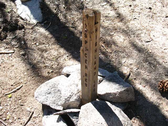
Northeast to PCT Jenkins Canyon to Highland Lakes |
TYT |
TYT-PCT Map Highland Creek to PCT |
Region Map Carson Iceberg Wilderness |
Lake Alpine to Saint Marys Pass MILES AND ELEVATIONS |
ALL TYT MAPS Lake Alpine to Saint Marys Pass |
Resupply North Lake Alpine Resupply South Kennedy Meadows |
National Forest Stanislaus NF |
all maps index |
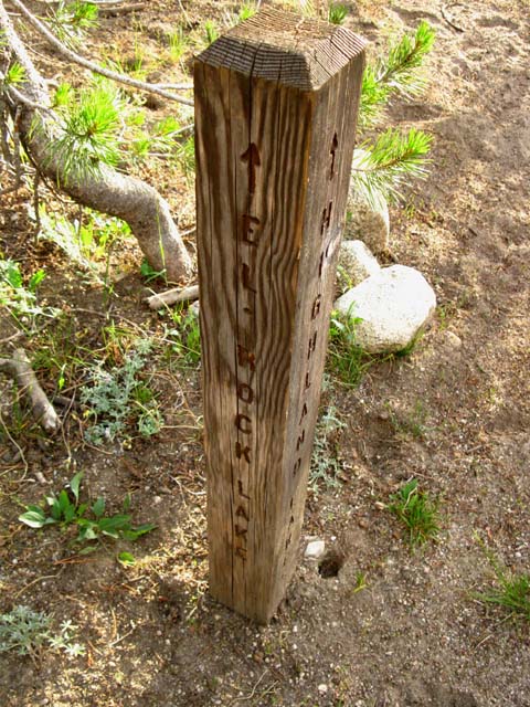
The Rock Lake Trail Junction
| Hiking South into the Rock Lake trail junction on the Tahoe to Yosemite Trail. | ||
 |
||
Left: South on the Tahoe to Yosemite Trail. Right: Southwest to Elephant Rock. Rock Lake is a few feet off to our Right. We'll cut to our Right down the Elephant Rock Trail for a few yards before we hike up the low ridge rising to our Left to find the Rock Lake campsites.
Rock Lake to Jenkins Canyon Forum |
Quick Facts 4.74 miles 5.65 miles 6.64 miles Alternative TYT to PCT route 16.64 miles 39.06 miles |
TWO WAYS IN Upcoming Route Options I'm thinking down the trail to the Jenkins Canyon trail junction. The Lay of the Land Carson Iceberg Wilderness Thinking Down the Trail Long Term Trail Planning We'll come back to the Carson Iceberg Wilderness between long distance hikes for more leisurely backpacking loops focused on exploring its nooks and crannies. We'll come back to focus on locations of intense beauty we could only scratch across the surface of while hiking under the constraints of the long trail. Food is Time is Distance Approaches to Backpacking We hope to draw on the best attributes of both. The best Ultralighters carry a very light, but still competent kit. But, many ultralight backpackers are very, very short of the gear necessary to counter the potential ranges of weather, temperature, and insects they may encounter. Yet Ultralighters, and the pursuit of lightness has driven gear technology to new levels of efficiency per ounce in every expression of gear technology. I hump it hard. My goal is to have the wisdom of an Ultralighter with the capacity of a Marine. This combination makes us capable across a wide range of applications, well geared for each, with the extra capacity necessary to make us expandable to emergency and Winter applications. On the long trails this capacity gives us extreme flexibility. We expand our basic trail and terrain knowledge on the forefront of long distance through-hiking, deepen this knowledge with a strong program of scrambling and exploration along the way, and repeatedly return to gain deeper understanding of the evolving logic of the terrain. The endless details of bottomless beauty we step over, around, and through while hiking the long trails demands we return, time and time again, to see if we can possibly put enough layers of experience onto the terrain to be able to see the bottom of the pool, if we dive deep enough, enough times. Terrain is big. We are little. Time is fleeting.
|
Backpacker's IndexRock Lake is a sweet odd-oblong shaped lake nestled beneath a fine mound of granite on its narrow Southwest shore. I guess that rock is why its called Rock Lake. Nobody knows love like a mosquito's love of our blood. I just like this place. It's nice. It's not really lush, nor barren. It's not too far from trailheads, and not too close. It's a perfect waypoint along a local loop, and a pleasing stay on the long trail. The surrounding burned forest and the dryness of the overall terrain impart a lean feeling, but this is mostly dispelled by the wet beauty of Rock Lake. Mostly. We can feel the dryness of the terrain. This is a forested desert surrounded by a burned wasteland, in some respects and aspects. It is also a sweet lake surrounded by lush meadow and encroaching forest. It is a contradiction. Pain and pleasure, hot and cold, up and down, wet and dry are the first in mind, each holding hands with us down the trail.
Rock Lake is Sweet Well, it was my fault, and I take responsibility for allowing it to happen, but I did take more than reasonable precautions..., more on this below. I take solace that my dumb-ass mistakes may prevent yours. Hell, everything is a challenge-everything is fun. Well, everything natural...
Rock Lake
Note: The Rock Lake junction is incorrectly located on the National Forest Carson-Iceberg Wilderness Map. I have corrected these omissions and errors on the Tahoe to Whitney USGS map, and added a bit of the National Forest map below that USGS map to show an official version of the current extent of Spicer Meadow Reservoir, as compared to my painted-in rendition of the reservoir.
|
||||||||||||||||||||||||||||||||||||||||||||||
The Rock Lake Trail Junction
| Looking South at the Rock Lake trail junction on the Tahoe to Yosemite Trail. | ||
 |
||
It Exists Though the Rock Lake trail junction and its accompanying trail down to Elephant Rock are not depicted on the 1979 USGS Spicer Meadow Reservoir 7.5 minute topo map, they do exist, as you can see by the trail junction pictured above. I added this junction and the trail route down to Elephant Rock on the Topo Map below, and the topo maps for this section of trail. Right Turn: The Southbound local-trip backpacker turns Right, Southwest, to hike down to Elephant Rock and Elephant Rock Lake. Hiking North from Elephant Rock Lake brings us back around to Silver Valley Trailhead through the wrecked cabin trail junction on the Southwest side of Duck Lake. Hiking South from Elephant Rock brings us to the road access at Elephant Rock Lake. Left Turn Southbound backpackers veer Left at Rock Lake, to the Southeast, in the direction of the arrow pointing towards Highland Lakes to continue South on the Tahoe to Yosemite Trail.
|
Topo Hiking Map
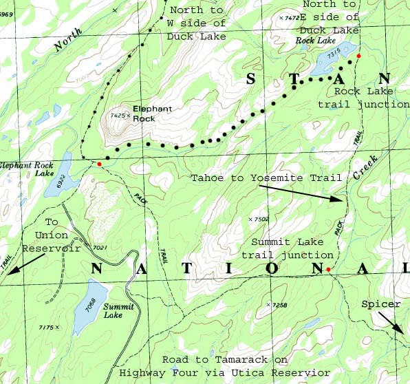
Rock Lake and Summit Lake Trail Junctions
Feeling Loopy? Duck Lake, Rock Lake, and Summit Lake each offer their own backpacking loop trips, each a bit longer than the last. The Duck Lake loop is the shortest loop, hiking around Summit Lake the longest, with the loop around Rock Lake representing a middle distance. The return route of all these short loops swings North past Elephant Rock Lake on a beautiful section of faint trail back up to Silver Valley Trailhead. These are nice little loops! Long distance backpackers hike past the Rock and Summit Lake trail junctions to remain on the main Tahoe to Yosemite Trail route. |
||
|
||
A Couple of Local Loops out of Silver Valley Trailhead Though not shown, we have the even smaller loop around Duck Lake before we expanded out to see the Rock and Summit Lake options. If you are a parent breaking in backpacking kids, or anyone who is expanding their backpacking skills by degree, these loops offer us three degrees of access to moderate-difficulty trails. The map above is a segment from the Spicer Meadow Reservoir 7.5 Topo Map available free from the USGS Map Store. I added the Rock Lake trail junction and trail to Elephant Rock that the USGS map omits. See the bigger Topo Hiking Map on this Trail Guide.
|
The Long and Short of It:
The TYT, PCT,
and their
Interlinked
Trail Options
Across
the
Carson Iceberg Wilderness
Arriving
|
| comments | Forum |
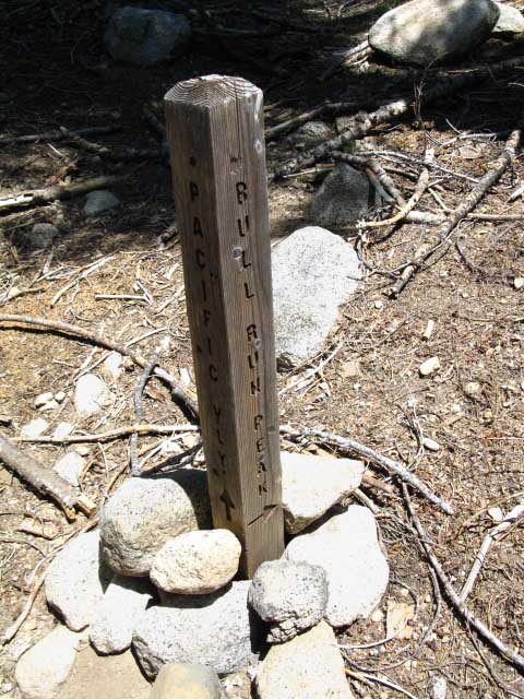
Well, now we find one trail up to Pacific Valley. The trail configuration has been changed, and the Western Bull Run trail and junction removed, leaving a single trail junction at the top of Spicer Meadow Reservoir.
This means that there is now a deteriorating unmaintained trail from Spicer Meadow Reservoir up the mountain to the Pacific Valley Trail along the old removed segment of trail.
The trail that was removed linked up with the trail from the second junction, which was, and still is the direct trail from Spicer Meadow Reservoir up to Pacific Valley on Highway 4. The trail that was removed was a secondary, subordinate route.
The remaining trail still allows us to craft nice medium distance hikes from the Silver Valley Trailhead to the Pacific Valley Trailhead past the top of Spicer Meadow Reservoir.
Continuing South on the TYT...
Our Tahoe to Yosemite Trail route bends Southeast around the top of Spicer Meadow Reservoir, bringing us alongside Highland Creek. Approaching Highland Creek we find the source of the roar of water during Spring, and the tinkling river-song we hear through the hushed forests of Summer.
Highland Creek is delightful. It tickles the senses. The eye with its ice-carved granite subsequently washed into unique forms by the erosive force of liquid water, the ear by our emergence from hushed forest into symphonic creek sounds, our logical mind by the complexity of the terrain that brings all this together.
Terrain reflects what our human assets were originally evolved to reflect and deal with. Terrain makes us feel its power, when we put ourselves into its clutches, rather than creating our own. Terrain is the crucible that humans were forged within, and we are a reflection of its glory, not our own.
Well, this is obvious, as everything we are and do are reflections of nature. Except as we separate ourselves from it.
Call that ability Will.
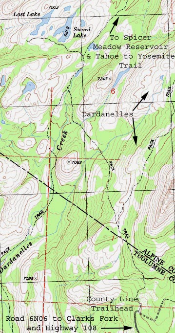
We will ourselves to follow Highland Creek Southwest upstream for a half mile before both begin bending Northeast, around to our Left, into the mouth of Highland Creek's upper canyon. Here we found the trail junction Southwest down to Sword and Lost Lakes just a few feet past the top of Spicer Meadow Reservoir.
From Sword and Lost Lakes we can exit the wilderness to the Highway 108 side of the Carson Iceberg through trailhead access at County Line trailhead accessible off of the Clarks Fork Road.
The trail beyond Sword and Lost Lakes takes us around the Southwest shoulder of The Dardanelles as the Tahoe to Yosemite Trail route will take us around its Northeast shoulder, and both routes ultimately access the Clarks Fork Road off of Highway 108.
The difference is that the TYT is a through trail.
We can find the County Line trailhead as a red dot located on the Carson Iceberg Wilderness topo map just South of the upper reaches of Spicer Meadow Reservoir. Zoom in on the map and we can see the route of the dirt road up from the Clarks Fork Road off of Highway 108.
Carson Iceberg Wilderness
30 minute USGS topo map
A mile and a quarter South of Spicer Meadow Reservoir up Highland Canyon past the Sword and Lost Lakes trail junction we encounter the Jenkins Canyon trail junction. Our Tahoe to Yosemite Trail route turns up Jenkins Canyon.
Jenkins Canyon Trail Junction Options
Here we will either turn Southeast, Right, out of Highland Canyon to hike through Jenkins Canyon over the Northeast shoulder of The Dardanelles Southbound on the Tahoe to Yosemite Trail or we will continue up Highland Canyon to access the PCT, or to end our trip at the road access from Highway 4 at the PG & E campgrounds at Highland Lakes.
| Spicer Reservoir to Highland Lakes 15 minute backpacking map |
Arnot and Disaster Creek Trails 15 minute backpacking map |
Highland Lakes is served by a great quality dirt road breaking off from Highway 4 just West of Ebbetts Pass.
Rather than ending our trip at Highland Lakes, we can easily hike over to the Pacific Crest Trail at Wolf Creek Pass through the beauties of Gardner Meadow. From Wolf Creek Pass we can hike North to Ebbetts Pass, or follow my plan to continue our long Southbound hike between Tahoe and Whitney along the Pacific Crest Trail South through the East Carson River Headwaters over to Highway 108 at Sonora Pass.
Wolf Creek Pass to East Carson River
15 minute backpacking map
If we are hiking the long trails South from Lake Tahoe to Mount Whitney there is no reason to limit ourselves to a single particular route. Unless we want to. We can weave together sections of the Pacific Crest Trail with sections of the Tahoe to Yosemite Trail to suite our tastes up here in the North Sierra.
Carson Iceberg Wilderness Trail Junctions:
We have interesting options...
As we can see, Jenkins Canyon is an important junction from our perspective. Here my particular preferences drive me off of the Tahoe to Yosemite Trail to follow Highland Creek through the remote desolation of Highland Canyon.
At the head of Highland Canyon we encounter the PG & E campgrounds between the back to back Highland Lakes. Just Northeast of Upper Highland Lake we hike through the Gardner Meadow Trailhead across Lower Gardner Meadow to join the Pacific Crest Trail at Wolf Creek Pass.
Our other alternative, hiking through Jenkins Canyon to the Clarks Fork along the Tahoe to Yosemite Trail, brings us into a large community of Summertime Car-Campers at the BIG car campgrounds along Clarks Fork Road. Although we also encounter road access at Highland Lakes, the tiny car campground at Highland Lakes is much quieter than the mini-cities that sprout up each Summer along the historic Clarks Fork Road.
All sorts of car campers know about the excellent deep Sierra access offered by the Clarks Road. Much fewer car folks know about or use Highland Lakes car campground.
This connector trail up Highland Creek to the Pacific Crest Trail at Wolf Creek Pass via Gardner Meadow is also our Northern access point to the Northern ends of the trails coming up Arnot and Disaster Creeks from their Tahoe to Yosemite Trailheads along the Clarks Fork Road. The map below Left shows the relationship between the Arnot and Disaster Creek Trailheads along the Clarks Fork Road with Highland Lakes off Highway 4, and the PCT at Wolf Creek Pass.
The map below Right puts all these trails into context.
| Arnot and Disaster Creek Trails 15 minute backpacking map |
Carson Iceberg Wilderness 30 minute USGS topo map |
These three trails, the Highland, Arnot, and Disaster Creek trails are lined up parallel to each other connecting the Tahoe to Yosemite and Pacific Crest Trails. These three rings of connecting trails invites us to hike many rewarding loops around them through here, as well as providing a set of very interesting options for through-hikers.
The map on the Left below shows the Highland Creek Trail, the map on the Right the Arnot and Disaster Creek trails, all connecting the Tahoe to Yosemite to the Pacific Crest Trail, each trail offering a great leg for the loop trip you are going to put together around the heart of the Carson Iceberg Wilderness, if you are so inclined.
| Spicer Reservoir to Highland Lakes 15 minute backpacking map |
Arnot and Disaster Creek Trails 15 minute backpacking map |
This Trail Guide Covers Both Options
Thus the trail guide splits here at Jenkins Canyon, with one branch following Highland Creek up to the Pacific Crest Trail, and the other following the Tahoe to Yosemite Trail up Jenkins Canyon over to the Southern end of Arnot Creek and out of the Arnot Creek Trailhead to road access onto the paved Clarks Fork Road. We'll hike up along the Clarks Fork of the Stanislaus River to the end of the road.
The Clarks Fork Road breaks off of Highway 108 about 8 miles West of the Kennedy Meadows Pack Station turnoff. We can see where the Tahoe to Yosemite Trail emerges from the Wilderness onto the Clarks Fork Road, and where the Clarks Fork Road connects with Highway 108 on the lower-Left side of the map below, and below the trail map we have road maps of both the Highway 108 and 4 corridors...
Carson Iceberg Wilderness Backpacking Map
USGS 30 minute hiking map
The Tahoe to Yosemite Trail route continues South up the paved Clarks Fork Road from where it emerges out of the Arnot Creek Trailhead, bringing us up past the Southern Trailhead of Disaster Creek, which is situated almost at the end of this old paved pioneer wagon road along the Clarks Fork of the Stanislaus River.
Just a few feet South of the Disaster Creek Trailhead we finally exit the top end of the Clarks Fork Road through the Clarks Fork Trailhead. This route was the second pioneer road over this section of the Sierra Crest, passing over both Saint Marys and Sonora Passes in the 1850s. This route over the Sierra was abandoned in favor of the third and final route, the much easier to maintain current route of Highway 108 up Deadman Creek.
The Boulder Creek and Lake trail up to the Pacific Crest Trail.
Hiking 2.56 miles of Intermediate 1 difficulty trail South of the Clarks Fork Trailhead at the end of the Clarks Road we encounter the Boulder Lake trail junction alongside Boulder Creek.
The 2.74 mile length of the Boulder Creek trail up to the PCT is the Southernmost of the four trails linking the TYT and PCT routes across the Carson Iceberg Wilderness between Lake Alpine and Saint Marys Pass, and its is also the shortest.
The trails connecting the TYT and the PCT through the Carson-Iceberg Wilderness are the Highland, Arnot, Disaster, and Boulder Creek Trails, from North to South.
Why?
Because I prefer crafting my own unique long distance hiking routes through any particular area after exploring the basic PCT and TYT long distance routes, if possible. After hiking both the Tahoe to Yosemite and Pacific Crest Trail routes from Highway 4 to Highway 108 many times it was logical to begin exploring other route options across the length of the Carson Iceberg Wilderness.
What I'd seen on the TYT and PCT encouraged me to explore the trails tying them together.
One year I headed up Highland Creek to join the PCT route. The next over the classic TYT. The third time through I headed up to the PCT through Boulder Creek. After doing both the conventional PCT and TYT routes through the Carson Iceberg, I found that my favorite route through the Carson Iceberg Wilderness incorporates sections of both the TYT and PCT.
My favorite route is hiking South on the TYT out of Lake Alpine, then crossing over to the Pacific Crest Trail through Highland Canyon, and then back to the TYT through Boulder Creek to finally exit the Carson-Iceberg Wilderness through the Saint Marys Pass Trailhead.
This is the longest and toughest way to cross the Carson Iceberg Wilderness on the long trail South to Mount Whitney.
Why South from Lake Alpine?
Because of my preference for the hiking the TYT South from Carson Pass. Our previous decision to hike the unmaintained segment of trail through the Summit City and N Mokelumne canyons to Lake Alpine on the TYT sets us up to continue hiking South on the TYT from Lake Alpine. That does not mean we have to continue South on the TYT.
TYT South into Lake Alpine
The Tahoe to Yosemite Trail's unmaintained route through granite and volcanic canyons across the Mokelumne Wilderness to our North easily overmatches the Pacific Crest Trail's route across the barren East Sierra.
The difficulties of hiking the unmaintained segment of the TYT through the Mokelumne Wilderness may drive other backpackers East onto the PCT as these same qualities draw cross country backpackers to the TYT. Thus I almost always hike into Lake Alpine on Highway 4 out of the TYT route through the North Mokelumne River.
Many backpackers are deterred by the unmaintained trail and rough terrain on the TYT route across the Mokelumne Wilderness, making the TYT section to our North a very quiet section of trail. I've only encountered a handful of hikers on this section of trail during the past two and a half decades.
My preference for hiking the TYT section through the Mokelumne Wilderness means that I'm hitting Highway 4 at Lake Alpine, and will likely continue South along the TYT out of Lake Alpine, unless I make the unlikely decision to hitch-hike 15 miles East up to Ebbetts Pass to continue South on the Pacific Crest Trail.
PCT South into Ebbetts Pass
The Pacific Crest Trail route between Carson Pass and Ebbetts Pass crosses volcanic terrain into and out of numerous sections of the Toiyabe National Forest and across Forest Service roads cut deep into the convoluted "boundary" of the Eastern Mokelumne Wilderness. The Eastern edge of the Mokelumne Wilderness is tattered like an old flag between Carson and Ebbetts Pass along the PCT.
I counted eight times passing into and out of the Mokelumne Wilderness hiking through this 28 mile section of trail.
Hey, I like four-wheelers, and I generally don't mind running into their roads, or the four-wheeler drivers themselves when they happen to cross my trail. But if you are looking for more isolation and less road access, the TYT route between Carson Pass and Lake Alpine is far preferable to the heavily-roaded PCT between Carson and Ebbetts Passes.
We continue South on the PCT across starkly beautiful barren volcanic terrain South across Ebbetts Pass. The volcanic terrain continues South until we cross over Tyron Peak. From there we begin to draw closer to the East Fork of the Carson River in its grand granite gorge topped with volcanic mountaintops.
It's at that point where the PCT approaches the middle of the Carson Iceberg Wilderness, where the Southbound TYT moves towards the busy campgrounds along the Clarks Fork Road that I switch trails from the TYT by hiking up Highland Canyon to the PCT.
I'll come back down to the TYT through Boulder Creek, once I hike far enough South on the PCT to put myself past the end of Clarks Fork Road and all of its people, if I come back down at all...
The Southern Carson Iceberg Wilderness
Both of our potential PCT and TYT routes cross exceptional terrain as they draw closer together approaching Highway 108 at the Southern end of the Carson Iceberg. Neither route is better than the other through here. Each has its own unique character, beauty, and challenges. Both are special places.
I really enjoy the fantastic granite formations and sheer walls of the upper sections of the East fork of the Carson River's canyon hiking the well-maintained PCT below the East flank of Stanislaus Peak.
On the West side of Stanislaus Peak the TYT is climbing a very rough unmaintained trail route into the narrowing isolation we find in the upper canyon of the Clarks Fork of the Stanislaus hiking towards Saint Marys Pass.
| TYT and PCT to Highway 108 USGS 15 minute map |
Sonora Pass Trailheads USGS 30 minute map |
Whichever route we choose this time through, we can do the other next time. These route manipulations are basically designed to put us on the most isolated trails, to avoid the road and car campers along along Clarks Fork Road, and give us a quick look at the beautiful terrain along the East fork of the Carson River before we cut back over to the TYT via Boulder Lake for the challenging hike over Saint Marys Pass.
And the Winner is...
You decide. Hike both routes then pick your favorite connector trails to put your favorite parts of each together. Make a fantastic backpacking route that explores your curiosities and capacities across the Carson Iceberg Wilderness.
Tune yourself up hiking the Carson Iceberg Wilderness.
Carson Iceberg Wilderness Backpacking Map
USGS 30 minute hiking map
Resupply
Following the TYT South from Carson Pass walks us into the Lake Alpine Lodge on the North end of the Carson Iceberg, where we can pick up the resupply bucket we sent our self through their free resupply service, rather than hitting Highway 4 at Ebbetts Pass, where the PCT's location crossing Highway 4 requires we hitch-hike fifteen miles West to pick up our resupply bucket at Lake Alpine.
Besides the free backpacker resupply service, the Lake Alpine Lodge has great food, showers, and laundry.
Kennedy Meadows Pack Station is our resupply spot on the South side of Carson Iceberg Wilderness, located nine miles West down Highway 108 from Sonora Pass. This is my favorite resupply spot. It has a package service for backpackers, great food, real nice people, along with a good backpacker store, and top quality showers and laundry.
Crossing Over
The reason I cross over to the Pacific Crest Trail South of Lake Alpine off the Tahoe to Yosemite Trail is that many of my favorite places in the Carson Iceberg Wilderness are located within its 10 mile section along the East Fork of the Carson River between Murray Canyon and Sonora Pass.
One of my first trips in the early 1990s was up the East Fork of the Carson River out of the Corral Valley Trailhead, which is off Highway 395 in Antelope Valley. It was a fairly remote starting point then, and still is today.
Though the Pacific Crest Trail brings a lot of hikers through this upper section of the East Carson River early every Summer, this area also has a lot to offer short and medium distance backpackers too, through local trailheads, such as the remote Corral Valley Trailhead off of Highway 395, the Sonora Pass Trailhead at the top of Highway 108, and the Arnot and Disaster Creek Trailheads on the old wagon road along the Clarks Fork of the Stanislaus.
In Conclusion
Short
We have many short and medium distance backpacking trips we can explore hiking South out of the Silver Valley Trailhead along the Tahoe to Yosemite Trail. Hiking loops South around Duck Lake, Rock Lake, Summit Lake, and Elephant Rock Lake are all good options for short backpacking loops out of the Silver Valley Trailhead.
Medium
Medium distance loops and point to point hiking trips can be constructed by hiking Northwest up over Bull Run Peak from Spicer Meadow Reservoir to Highway 4 at the Pacific Grade Summit (Pacific Valley), by following Highland Creek North up to road access at Highland Lakes, or by hiking out to Highway 108 through County Line Trailhead via Lost and Sword Lakes.
What a great set of trips!
Long
Extending the length of our Tahoe to Yosemite Trail hike across the length of the Carson Iceberg Wilderness can be achieved by starting South out of Silver Valley on the TYT and joining up with the PCT at Wolf Creek Pass via Highland Creek and Lakes. From Wolf Creek Pass we can continue our Southbound hike on the PCT down to Sonora Pass via the East Carson River.
Arriving at Sonora Pass along the Pacific Crest Trail we have much the same options we had hiking South into Saint Marys Pass: hitch-hiking down to Kennedy Meadows to resupply and continue South to Yosemite along the Tahoe to Yosemite Trail, or cross the road and continue South on the Pacific Crest Trail.
Well, that's not practical. We must rest and resupply before tackling the 73.71 miles of the PCT from Sonora Pass to Tuolumne Meadows. Well, you don't have to stop and resupply. In late September of 2009 I hiked the whole TYT from Meeks to Tuolumne Meadows carrying all the food I needed.
It's probably unnecessary to state that my pack was obnoxiously heavy for the first half of the trip.
That's why we lift weights...
Big Loops
The longest hikes in the Carson Iceberg involve hiking one route South through the Carson Iceberg, then switching over to the other route for our return journey. For example, hike South down to Saint Marys Pass from Lake Alpine on the TYT, then hike the mile East up to the Northbound PCT trailhead at Sonora Pass. From Sonora Pass hike North back to Lake Alpine along the PCT route. We will have to use one of our four connector trails to cross back over to the TYT approaching Lake Alpine. This trip runs a tad under 80 miles.
Whichever route we decide on for our hike South to Highway 108 from Highway 4, either the challenging unmaintained segment of the TYT over Saint Marys Pass to Highway 108, or to the Sonora Pass trailhead along the PCT via the East Carson River, we can easily switch over to the other trail route for the return loop of our hike back to Highway 4, or we can continue continue South across the Emigrant Wilderness to Yosemite.
Which Way South?
Bits of Both!
The Southbound Tahoe to Yosemite trailhead is offset 9 miles West from Saint Marys Pass Trailhead down Highway 108 at Kennedy Meadows, while the Southbound PCT route is across Highway 108.
The question for me is not "Am I going to hike the PCT or the TYT from Lake Tahoe to Yosemite?", but "Which sections of the PCT and TYT am I going to hike on my way down to Yosemite?"
Honestly, the answer to that question depends on how I feel, and how many bucks I have in my pocket, and at this point of building the trail guide, which parts of the trails I'm lacking video and images of, or have some perplexing question about.
Then there's the "must do" list..., and the list of dreams.
So many trails, So little time.
| Spicer Meadow Reservoir to PCT via Highland Creek USGS 15 minute topo hiking map |
Lake Alpine to Saint Marys Pass Backpacking Miles and Elevations |
Jenkins Canyon trail junction
6.64 miles
South of Rock Lake.
5.83 miles
North of the Arnot Creek Trailhead, just above Clarks Fork Road.
23.26 miles
North of Saint Marys Pass along the TYT.
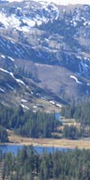
Rock Lake, Carson-Iceberg Wilderness
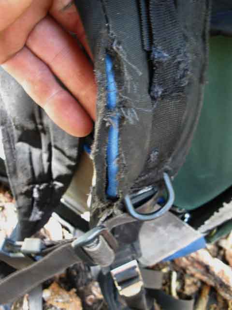
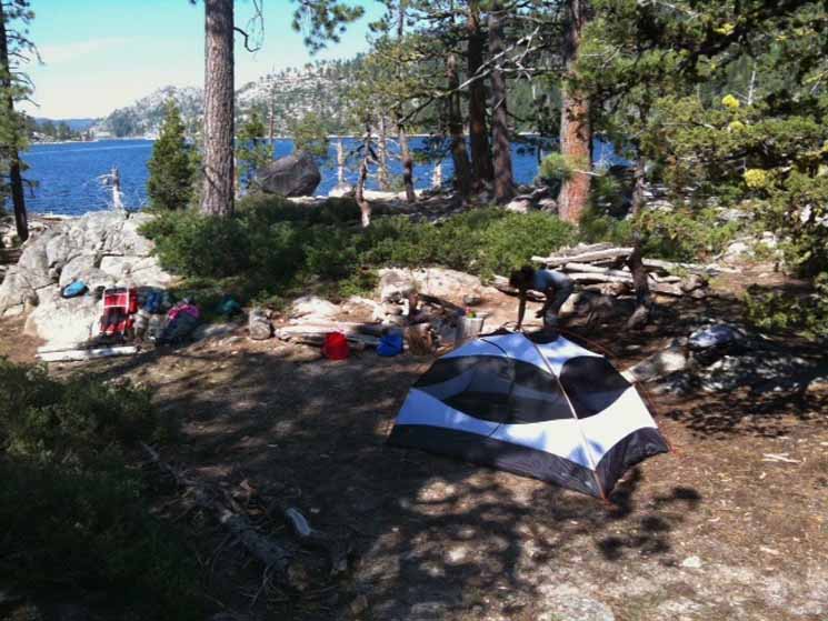
Rock Lake CampsitesRock Lake Junction The Rock Lake campsites are located atop the low knoll that rises on the South side of the lake. We access them by hiking Right through the trail junction for about a hundred feet, then cutting Left up onto the hill along the South shore of Rock Lake. Along the flat top of the knoll are a series of fine campsites set among low granite boulders within thin forest. On the high central point of the knoll a large campsite with a huge fire ring suitable for large hiking parties, Boy Scouts, or horse packers. Smaller sites are scattered up and down along the top of the knoll. It is my long term practice to secure my pack every night against local threats. During Winter I bungee cord it to a tree, in case of heavy snow and wind. If your gear is spread out on the ground during a snowstorm you will likely not find most of it, and have a hard time finding any of it. During Summer the main threats are rain, wind, and animals. Having your pack fill up with rainwater is not as bad as having a bear slash it open to remove your suntan lotion. Neither is a desirable outcome. I employ a camp procedure the involves removing all food and animal edibles from my pack, then making sure it's sealed up against rain and secured against wind. Before sleep I secure all food and potential bear edibles. My standard practice is to secure all zippers, pockets, and flaps before laying the pack flat on the ground, shoulder straps and hip belt inside the edges of my external frame pack tubes. Then I put a good sized rock on top. This is to dissuade salt-seeking critters from flipping my pack and chewing the shit out of my hip belt and backpacking straps. You'd think that would be enough... Sometime very early in the morning of Thursday July 23rd I woke up to a scratching sound. looking towards my pack while still reclined I saw a gopher stick his head out of a new hole about half way between me and my pack. "Cool," I thought, as the twitchy gopher returned my gaze, while fidgeting about. It dropped out of sight back down its hole, and I dropped back off to sleep. After breakfast, morning activities turned towards getting ready for the trail. I walked over to my pack, removed the great rock securing it, and almost shit myself when I saw the tattered remnants of my shoulder straps hanging from the frame. The hip belt was not as bad, more slashed up than completely eaten up, as were the shoulder straps. That darn gopher had eaten out the seams! I had taken all reasonable precautions, but I was amazed to see that the darn gopher had actually pushed a hole up under my pack to get at my strappage. I had likely caught it while on its way to my pack, then went back to sleep, like a fool.
Good thing I always carry a couple of webbing loops... My webbing loops were soon deployed to reinforce the weakened shoulder straps. Lake Alpine to Saint Marys Pass 4.74 miles South to the Rock Lake junction from Silver Valley Trailhead. 5.5 miles South from the Rock Lake junction to the Northeast end of Spicer Meadow Reservoir, where there are nice spots to take a break, water-up, or camp. |
Rock Lake Video Tour:
Campsites on the knoll South of Rock Lake
| Video Fine Campsites located on the rise on the South side of Rock Lake. |
||
Duration: 3:08.
|
Rock Lake Campsites
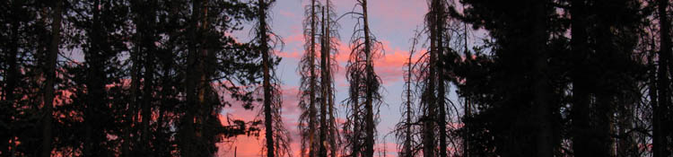
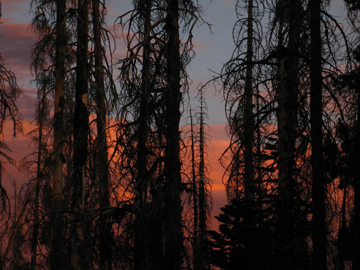
| Sunset from Rock Lake Campsite. | ||
 |
||
FIRE CLOUDS Signs notifying hikers of trail closures around the WILDCAT fire zone were posted at major trail junctions further South, as I entered Yosemite. The effects of these fires were more than stunning sunsets. Hazy daytime skies affected photography, and the smell of fire filled the air, provoking thoughts of escape routes. The Arnold Fire kept me observing the Western flank of the Sierra for signs the fire was racing up mountain on the wind. Our nose and eyes will inform us of fire long before your fellow man. When I smell smoke and see haze I think of possible points of protection and escape routes if fire approaches.
|
Rock Lake Campsites
| Fine granite table at Rock Lake campsite. |
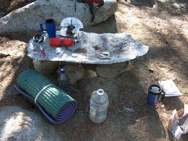 |
One of the many little luxury campsites on the low ridge at Rock Lake. Very comfortable-Very relaxing. |
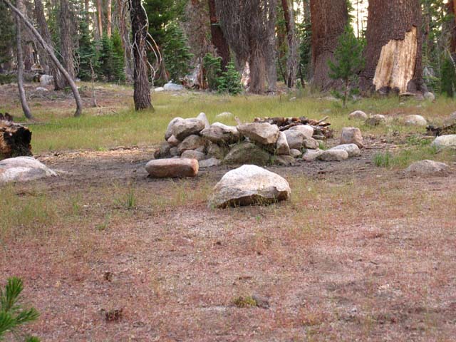
Rock Lake Campsites
| Big fire ring and big campsite centrally located among many little campsites on the low rise above the South shore of Rock Lake. | ||
 |
||
This campsite is at the top center position on the knoll rising off the South shore of Rock Lake.
|
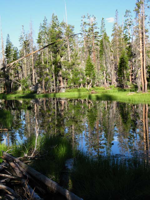
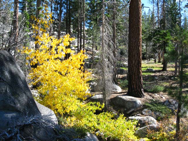
Rock LakeRock Lake is a diminishing lake set within a mostly unburned section of forest and meadow. I say a diminishing lake because lodgepole pines have already penetrated the meadows surrounding Rock Lake while a process of sedimentation and tree growth are simultaneously working to fill the lake. As sedimentation fills the lake into meadow the lodgepoles continue advancing, turning meadow into forest floor. Fir trees follow the lodgepoles, displacing them as the lodgepoles displaced the meadow, all working to eventually displace Rock Lake, as the combined forces of geology, meteorology, and biology slowly turn this place into a white pine and fir forest. Coming Back from the Future we find this delightful lake slowly losing the fight of its life. |
| Rock Lake. |
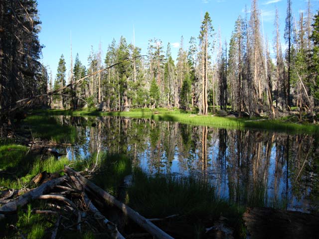 |
Note the lodgepoles marching across the meadows up to the North shore of Rock Lake. This is very unlike the scene we saw at Duck Lake. |
Rock Lake
| Rock Lake in the Stanislaus National Forest. | ||
 |
||
These lodgepoles and firs are sealing up the lake side meadows, as we can see, as silent sediment deposition fills the lake. As one force of nature slowly fills the lake with sediments, another force of nature, the pines, are moving at the proper pace required to eventually capitalize on this process. The verdant green grasses around Rock Lake are beauty with a bite, as they hold significant populations of mosquitoes.
|
Rock Lake Rock
| The Rock on the Southwest shore of Rock Lake. |
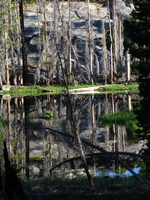 |
Though fire swept through Rock Lake, more of the forest survived than burned. |
Rock Lake to Spicer Meadow Reservoir
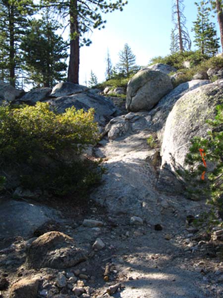
South from Rock Lake on the Tahoe to Yosemite TrailSouthbound Left through Rock Lake Junction
Carson Iceberg Wilderness 30 minute USGS topo map The Southbound Tahoe to Yosemite Trail climbs gently but steadily over a series of low granite ridges descending from Bull Run Peak to our Northeast. 1.19 miles South of Rock Lake we come to the Summit Lake trail junction. Staying on the Tahoe to Yosemite Trail our route begins bending Southeast from the Summit Lake trail junction for another gently but steadily rising 1.96 miles until we come to the top of the overlook above the Northern side of the narrow granite river valley that once held stunning sections of Highland Creek, but now contains Spicer Meadow Reservoir. This can be a hot section of difficult trail for those of us starting trips out of Lake Alpine who are not yet adjusted to altitude (7000 feet is at the lower end of altitude effects), the pack weight, and the rigors of the trail. The steady climb of this Intermediate-1 (most difficult level of middle-difficulty trails) will not present much of a problem for those of us who have hiked down from Meeks Bay, and somewhat adjusted to altitude, pack weight, and trail conditions. From this high overlook above Spicer Meadow Reservoir the Tahoe to Yosemite Trail parallels, and gradually traverses 2.2 miles Northeast along the shoreline down to lake level at the far Eastern end of the reservoir. This section of the trail between Rock Lake and the Northeast end, the top of Spicer Meadow Reservoir, is 5.35 miles. Lake Alpine to Saint Marys Pass 1.19 miles 5.5 miles 10.24 miles |
Let's take a look at the Trail and the Terrain
| Rock Lake to Spicer Meadow Reservoir THE VIDEO! |
||
Duration: 9:28.
|
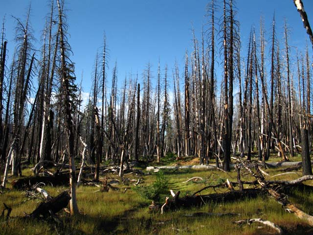
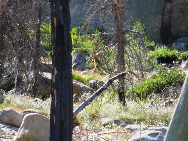
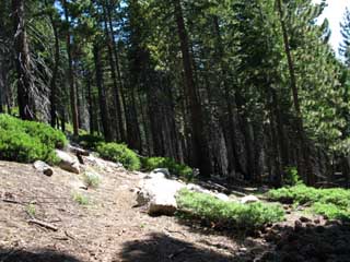
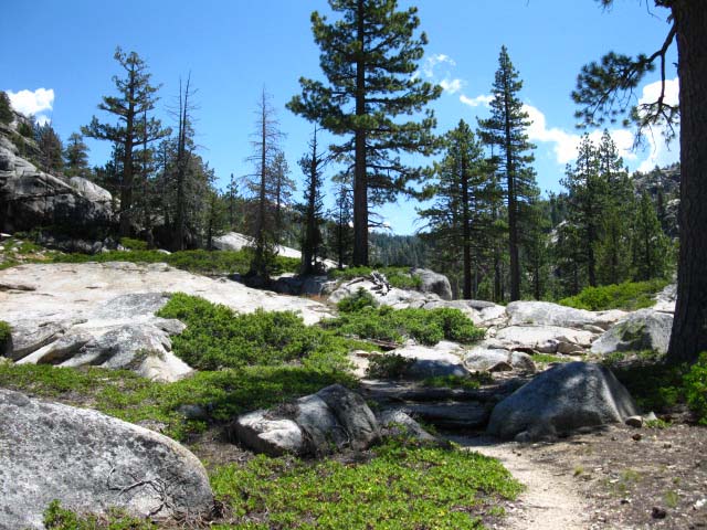
South of Rock Lake we gently climb through a series of rising undulations. We're hiking across rolling terrain containing alternating segments of burned and whole forest that's gaining a bit of elevation. |
| Starkness of the burned forest South of Rock Lake on the Tahoe to Yosemite Trail. | ||
 |
||
Burned sections are soon relieved by sections of live forest. This forest has not regrown during the 25 years I've hiked across it. I'd say that the weather will not support restoration of the lodgepole-fir-white pine forest here, having shifted to a drier and hotter environment than the firs and lodgepoles can tolerate. I would not be surprised to find the drier species of pine, such as the Jefferies and Yellow/Ponderosa Pines ultimately filling this niche in a long term transition towards very high elevation Pinion Pines. We may have already driven the future of the Sierra to a fate much like that of the dry mountains to the East of the Sierra Nevada, where dry pines grow to the crest. It is more likely that burned forest will regrow drier tree species than those that burned.
|
Carson Iceberg Wilderness Forests
| Healthy forest and burned sections intermingle. | ||
 |
||
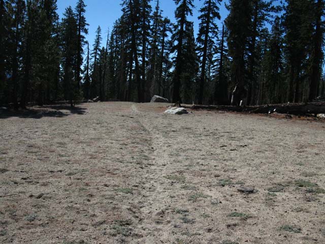
Sandy Terrain The result is that the light backpacker traffic of 2011 has allowed the trail to "grow in" and heal up. Trail conditions can tell us much about what the area is experiencing. Hell, everything we can see tells us about everything we can't, if we look closely enough. Hint Think of the known as the "metadata" of the unknown... haha...
|
Summit Lake Trail Junction 1.19 miles South of Rock Lake we encounter the Summit Lake Trail Junction branching off to the Southwest, the Southbound hiker's Right. |
| Junction to trail leading off to the Southbound hiker's Right, off the Tahoe to Yosemite Trail down to Summit Lake. | ||||
 |
||||
The Summit Trail points Southwest towards Summit Lake, and runs into the same dirt road running out to Elephant Rock Lake before we reach Summit Lake. The end of the dirt road at Elephant Rock Lake is also accessible via our last trail junction at Rock Lake. The Rock and Summit Lake trail junctions allow us to craft loops out of and back to the Silver Valley Trailhead of two different diameters. Have you done this loop?
Local Backpacking Trip
George and Sue are showing us how to open up the possibilities of exploring the granite and forest beyond the confines of the trail revealing great treasures hidden in the terrain. Warning |
South on the Tahoe to Yosemite Trail from the Summit Lake Trail Junction
| Granite, Aspen, and Pine Forest in a park-like setting. |
 |
When you see Aspen, look for water. Aspen marks the location of creeks. We're about to cross a burbling brook at our feet. |
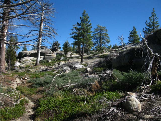
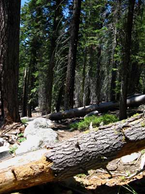
Climbing Series of Ridges
| Tahoe to Yosemite Trail winding its way through granite boulder strewn terrain between Summit Lake junction and Spicer Meadow Reservoir. |
 |
Very relaxing sections of trail and terrain. Note the construction tape on the far-Right edge, middle of the image. I was disappointed to see this tape, but I only saw the tape after finding the trail. |
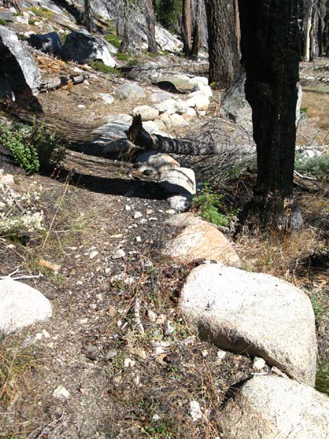
Bits of Faint Trail
| The trail disappears into the moving soils of an unstable wet meadow. | ||
 |
||
Observing carefully we find a bit of construction tape marking where the trail continues South. What if the tape is gone, and the trail is missing? I use the "last know position" method of route finding when trail goes faint, or away. You too should be ready to use whatever route finding technique suites you, when the trail fades or disappears. I understand those of us who get irritated when the trail goes away, or exasperated when every ridgetop we climb to leads to yet another, higher ridge, beyond. I was once like that, but no longer. Now I always note, and can find my way back to my last known point of trail. When trail disappears I observe the situation, and hike in the direction I believe most likely to find trail continuing on. If I'm wrong I return to that Last Know Point along the trail, then try my luck again at the next-most likely location I hope to find the trail. Well, that approach works on regular trails that are only broken for short lengths. For longer stretches of route finding we've got to have a deeper understanding of the overall context of the terrain and where we want to be in it in relation to a known destination. In other words, we must be able to identify and navigate to a known point in the upcoming terrain, such as a canyon mouth or the correct gap in the crestline. We must be able to follow the logic of the terrain while submerged under dense forest cover and while within complex rocky terrain. We will likely only be infrequently emerging into broad views of the surrounding terrain. Every time we do get a view of our surrounding terrain and our destination we must study it to reveal and hopefully come to some understanding of the logic of the terrain, which shows us the potential routes to our destination. To deal with route finding and navigation we must be able to maintain our line, and our understanding of our position in the terrain, when we are submerged under dense forest and in complex rock between overviews while finding our way to our destination. We must obtain and maintain near and far contextual understanding even when we cannot see far. Hell, it's especially important to maintain contextual understanding when we can't see far! How I'll do this is take a compass bearing on my destination from an overview position, then note how far I'm off-setting from that line as I find my way through dense forests or complex rocky terrain. I'll have to make up that offset to arrive at my selected destination. I'll seek out overview points to correct my line as possible along the way. If my projected route does not work, I'll go back to my last known position better informed to make my next route selection decision. We may have to backtrack and try again a few times as we establish a route through difficult terrain segment by segment. This is grand fun that can make the hair on the back of our neck stand up. Physically grappling with getting across unknown spaces and terrain triggers otherwise unknown spaces in our head that are only triggered when we cross the divide between the known and unknown. Route finding is a form of controlled chaos, of being lost in a known manner. Known in that we are only lost in front of us. We've already discovered a set of "Known Points," scattered behind us that we can follow back to trail. Thus I've pretty much stopped "getting lost." Nowadays I'm "Exploring Unknown Territory." This, my friends, is what nature designed us to do: It created us to find or make route across all types of terrain while carrying a heavy load through all weather conditions while chasing or being chased. That's us at our finest, the tip of Nature's Living Spear.
Endless Ridges? I always expect there to be a higher ridge beyond the next. Controlling our expectations controls our emotions. A bad attitude or mismatched expectations makes our pack unbearably heavy. Don't put "mental" rocks into your own pack! Let's build our skills and fitness gradually, making each step down the trail our logical next step, so we don't over stress mind or body. I'm speaking as much to those of us who are doing rehab from injury, or are trying to restore fitness after too long of a break, as to new backpackers first evolving backcountry skills and fitness. These challenges can make us or break us. Likely both, if we stay at it long enough. Thus we exercise caution in selecting the route best suited for our fitness and skills, and exercise when not backpacking. Expect success - Be ready for failure - Train for Both |
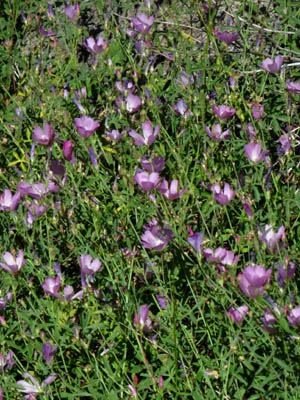
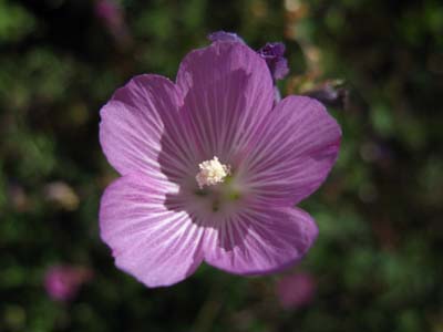
| The Beauty Continues Delicate purple flowers were growing profusely throughout the meadows. |
| Meadow full of purple delights. | How delightful. | |||
 |
 |
|||
Flower Forum: The above links to the flowers section of the living things forum.
|
||||
| top of page |
Trail Marker
| On the far side of the meadow a bit of construction tape marks the resumption of the trail. |
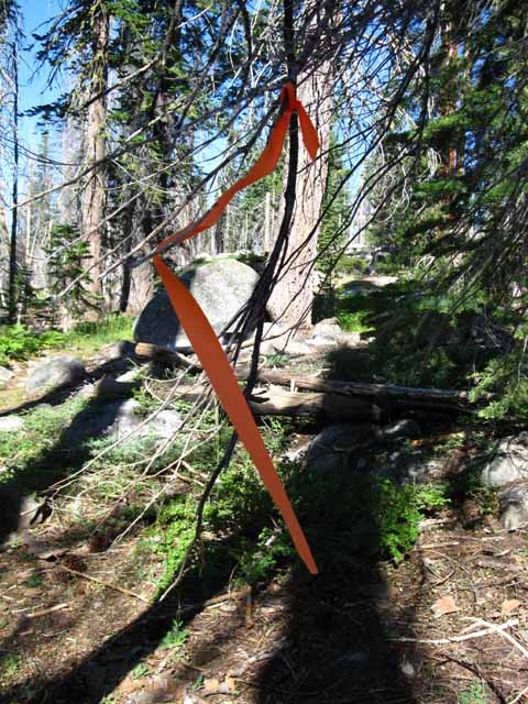 |
Very Temporary Trail Marker I was thinking the tape was put up to guide trail crew, but subsequent hikers in 2013 and 2014 have noted difficulty keeping on the trail through this burned section. Note how the examples of construction tape are tied to dead branches. This assures that they will break off at some not-so-distant point in time, when the dead branch breaks off. Thus this tape is marking trail only for a limited time. Be a good bloke and carry it out when you find it along the trail. |
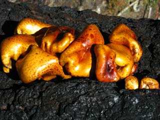
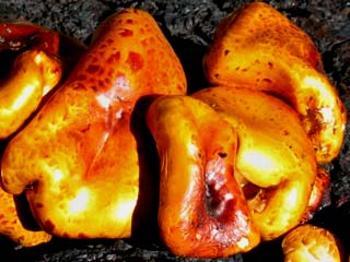
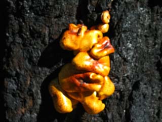
Fungus Amongus
| Fungus growing on old burned fallen snag. | Detail. | |||||
 |
 |
|||||
 |
 |
|||||
Fungus grows on snags, downed, and burned trees. Check out the Fungus Forum in the Living Things section of the Tahoe to Whitney Backpacker's Forum. Guide |
||||||
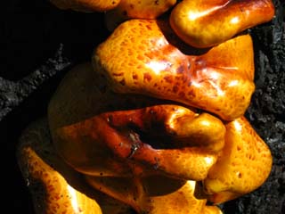
| Shrooming | ||||||
| The surface of the sun and the surface of the fungus have some small resemblance. | ||
 |
||
Note the difference in color from the fungus encountered up in the Mokelumne Wilderness. I'm thinking that downed trees provide different nutrients to the fungi than burned trees, resulting in different colored fungi. Guide
|
Old Trail of Character and Quality
| TYT winding along narrow forested cut around the nose of one of the ridges descending off of Bull Run Peak. | ||
 |
||
Old trail work intact many years after construction. Big rocks laid along the edge of this descending segment of meadow, off to our Right, have preserved trail through this "soft" meadow-terrain that would have melted away the trail away years ago without such well thought out and executed trail work.
|
Shooting for the Gap
| Crossing Last ridge. | ||
 |
||
The trail from Rock Lake to Spicer Meadow Reservoir describes a big semi-circle-segment South bending Southeast, and then East over and around the lower ends of granite ridges descending from Bull Run Peak. This last one is a long steady climb.
Lake Alpine to Saint Marys Pass |
Fingers of Fire
| Crossing another burned section. |
 |
The burned sections impart a unique feeling of desolation and isolation. We can see that we're coming around to the high point of the ridge above Spicer Meadow Reservoir, channeling up to a granite gap through which we will stand above the fantastic granite gorge that once held Highland Creek, but is now filled by Spicer Meadow Reservoir. Looking across Spicer Meadow Reservoir we see the ancient hulking volcanic mass of The Dardanelles. Views of the Dardanelles have been blocked by the rolling terrain, but we are coming closer and closer to this magnificent feature as we hike South to Spicer Meadow Reservoir. |
The Dardanelles
| The Dardanelles come clearly into view. | ||
 |
||
We've viewed glimpses of the Dardanelles since crossing over Mount Reba, now it is the dominant feature. Highway 108 and the Clarks Fork Road alongside its namesake river all sit on the other side, the South side of the Dardanelles. These remote mountain highways up 108 and 4 push close together here, as the bird flies and the backpacker hikes, but are quite distant if one drives from Lake Alpine on Highway 4 to the Clarks Fork Road off Highway 108. The Dardanelles rises above amazing granite terrain, telling us we are approaching another granite-volcanic interface.
|
The Dardanelles
| The Dardanelles, Carson Iceberg Wilderness, Tahoe to Yosemite Trail view. |
 |
This is the iconic "pincer" feature distinguishing the top of The Dardanelles. The feature on the Left is noted as "The Dardanelles Cone." |
Solid Trail
| Nice rock trail work climbing up towards Spicer Meadow Reservoir. |
 |
Note the stability of the main rocks even though the gravel fill between the rocks, known as riprap by trail crew, have been slowly swept away by runoff over many many years. This feature would be good as new with a little addition of riprap. Trail Tech |
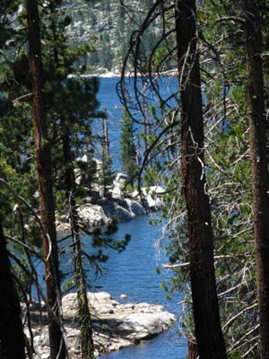
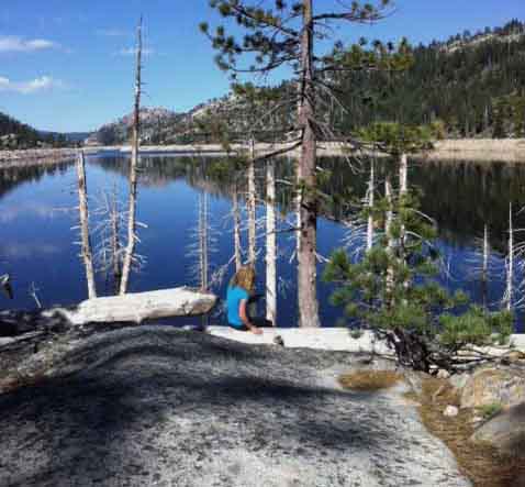
First View of Spicer Meadow Reservoir
| First view of Spicer Meadow Reservoir, looking Southwest. | ||
 |
||
This first view we get down into the valley at the reservoir's waters is just a bit North of the second point we see the water, coming through the gap, which is where we are actually overlooking the whole length of reservoir and at the point where we begin the long traverse Northeast along the reservoir's North shore down to lake level. Here we are looking Southwest down towards the dam. From this first viewpoint we still have a short hike to actually overlook the whole reservoir and begin the long traverse Northeast down to lake level. At the end of the traverse we arrive at lake level on the far Northeastern end of the reservoir where the trail junction up to Pacific Valley and nice lakeside campsites are located.
|
Dropping down to Lakeside, Looking Southeast
October 2011: Low Water
Images Below: Looking North of East at the top of Spicer Meadow Reservoir and into the bottom of Highland Canyon on the upper Right of the image. Highland Creek flows through Highland Canyon into the reservoir to the right of the barren ridge (peak 7635) located just behind the reservoir.
The Southbound Tahoe to Yosemite Trail bends around the Northeast end, the top end of Spicer Meadow Reservoir seen in the images below, between the water and the barren ridge. On the Right side of the reservoir the TYT turns East to pass by the Right side of the barren ridge entering Highland Creek's canyon. Tahoe to Yosemite Trail hikers enter the Highland Creek canyon for a short hike before encountering the Jenkins Canyon trail junction and turning Right. Jenkins Canyon is the first canyon visible beyond and to the Right of the lower Right end of the barren ridge. From this location we can see that the Tahoe to Yosemite Trail makes a rough "S" turn through the terrain around the head of Spicer Meadow Reservoir. The bottom part of the "S" passes between Peak 7635 and the reservoir, the middle part of the "S" bends up Highland Creek, then the top of the "S" turns out through Jenkins Canyon. On the compass the TYT first runs South passing by the top of the Reservoir, then turns East around the Right side of the barren ridge up Highland Creek, and then shortly turns Right, or South up Jenkins Canyon. That's a big "S," or more precisely, a backwards "Z" shaped route. Jenkins Canyon Jenkins Canyon can be located in the first image below on the Right side of the image by using the "V" created by the two trees on the upper Right side of the image as a gunsight. The "V" created by these two trees lines up exactly with Jenkins Canyon. Additionally, the pointy mountain peak on the right side of the Sierra Crestline, which is visible in the far distance, is Stanislaus Peak. We can't see it from here, but the Pacific Crest Trail route runs North and South on the other side, the East flank of the crestline holding Stanislaus Peak. We are looking at, and gradually approaching the West Flank of the Sierra Crestline under Stanislaus Peak in the far distance. |
||
 |
||
We now begin a long traverse down to water level paralleling the shoreline of the reservoir to our left. We will finally drop down to lake level on the far Northeast end of the reservoir. Then we will bend our "S" turn around the top of the Reservoir. The position above and below is from a vantage point where we can make out the upcoming route.
|
July 2009: High Water
| Looking up Highland Creek Canyon | ||
 |
||
Blue waters of upper Spicer Meadow Reservoir. Note the almost exact same spot images taken two years apart... The bottom of the "gunsight V" of the trees in this image is pointing a bit low, at the canyon preceding Jenkins Canyon. You can differentiate these canyons by their differing shades of green in the image above. You should have no trouble navigating this segment of trail. All trail junctions and the trail are well marked and clear. There are a couple of segments of faint trail along the route up Highland Canyon beyond the TYT turnoff up Jenkins Canyon.
|
Down to the North Shore of Spicer Meadow Reservoir
| Along and down the North Shore of Spicer Meadow Reservoir to the campsites along the far Northeast end of the reservoir. |
| Looking back, North, up the Tahoe to Yosemite Trail at a section of thick manzanita on the trail down to the shore of Spicer Meadow Reservoir. | Before us to the South on our way down to Spicer we again enter dense, cooler forest. | |||||
 |
 |
|||||
| top of page | From pushing through fully exposed terrain lined with thick manzanita-hedged trails it is nice to pass back under shaded forest. |
Downs go Up You think you are going "down-mountain?" Ha! Nothing is what it seems. As we hike down towards Lake level we will have to follow the trail as it climbs up and around steep and impassable areas down to the reservoir and along its shoreline. Nice Campsites along North side of Reservoir As the trail brings us down approaching water level towards the head of the reservoir, but before the trail turns Southwest around the top of the reservoir, we notice fine flats off to our Right under rich forest cover in near proximity to the reservoir, while we are still hiking along the North Shore. As the trail is still situated high up above the reservoir up on the side of the canyon even as we approach the top end of the reservoir, these flats are a couple of hundred yards to the Right of the Southbound backpacker, South below the trail. Just saying... |
Video Down to the Northeast side of Spicer Meadow Reservoir. |
||||
Duration: 11:26.
|
Hiking South down to Lake Level
| The obstacles that have decorated the Tahoe to Yosemite Trail since heading South of Highway 88 continue along Spicer Meadow Reservoir. | We get glimpses of the reservoir a we descend towards the reservoir through the dense forest cover. This is where the nice sites along the North Shore that I mention above are located. | |||||
 |
 |
|||||
Two downed snags across the trail. This is why we do sit-ups. Controlling the pack is vital when climbing over obstacles. |
We are getting much closer to the Water.
|
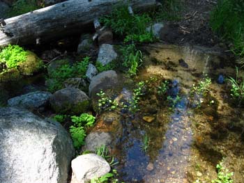
Two almost year-round creeks on the North side of Spicer Meadow Reservoir
| The first of the two creeks near the Northeast side of Spicer Meadow Reservoir. | The Second Creek. | |||||
 |
 |
|||||
| Look around as you approach the Northeast end of Spicer. You will note the shattered remnants of huge trees swept down and smashed by old catastrophic Spring Thaws. | Gentle Summer flow.
|
Trail Junction Anomaly
The Bull Creek Trail Junction is GONE!
| MISSING IN ACTION BULL RUN TRAIL JUNCTION. |
||
 |
||
A trail route modification was also executed along the Tahoe to Yosemite Trail route between the location of the old Bull Run trail junction (above) and the new Pacific Valley trail junction (below). If you have not hiked through here for a while you will find a significant change in the trail junction configuration. The trail junction above, and the trail to it, were both removed as of September 2009. |
A significant change
of
Two Trail Junction's configurations and locations
along this section
of the
Tahoe to Yosemite Trail.
I was a bit perplexed when I failed to encounter the Bull Run Creek trail junction.
The Old Trail Junction Configuration Location: Southbound Tahoe to Yosemite Trail approaching and around the Northeast shore of Spicer Meadow Reservoir Previous experience and the USGS and Forest Service topo maps both depict two trails accessing the far Northeast shore of Spicer Meadow Reservoir near the location where our Southbound traverse down to the water level reaches its closest point to the reservoir. I have seen these two trail junctions on many trips and photographed them on a couple of occasions. (Note that the USGS maps do not depict the upper section of Spicer Meadow Reservoir itself. I have added a rough approximation of the current outline of the reservoir on our customized Tahoe to Whitney Hiking Maps, and also included a segment of the Forest Service map of the Carson Iceberg Wilderness that does depict Spicer below the first map linked to above. Scroll down below the top USGS map to see the Forest Service topo map depicting Spicer Meadow Reservoir with cartographic accuracy. Thus I always expect to pass by two trail junctions before reaching the far end of Spicer Meadow Reservoir. Not anymore. Now there is one trail junction at the far end of Spicer, the Pacific Valley trail junction. The first trail junction was traditionally encountered while hiking Southbound along the far end of the North shore of Spicer Meadow Reservoir as the trail traverses down close towards water level. This was the junction marked Bull Run Creek. There was no trace remaining of the first trail junction, the Bull Run Creek junction along the TYT (pictured below as it was on July 23rd of 2009), at its former location as marked on all the maps when I hiked through on October 23rd of 2011. I was perplexed when I did not encounter the junction where I expected it to be, and even more so when I reached the Northeast end of Spicer Meadow Reservoir without passing the second of the trail junctions, the Pacific Valley Trail junction, as I was accustomed.
Above: The missing Bull Run Creek trail junction.
Second Trail Junction Though both trails ended up at the same place, Pacific Valley Road off of Highway 4, the second trail junction, the Pacific Valley Trail took an easier, but longer way up the Southeast flank of Bull Run Peak to meet with the first trail, the Bull Run Creek Trail, just under the Southwest flank of Bull Run Peak's summit.
Local Loopage Note on the map above Right the trail down Arnot Creek. Following the trail from Highland Lakes down the faintly trailed Highland Creek to Spicer Meadow Reservoir can be looped back up to Highland Lake via Arnot Creek. The campsites along the end of Spicer Meadow Reservoir are a nice place to kick back and/or camp while hiking the long trails South, or as a destination for a local backpacking loop on its own merits. Trail Note The Bull Run trail junction at the end of Spicer Meadow Reservoir sits at the base of the Southern Flank of Bull Run Peak. Bull Run Peak has been the dominant feature of our hike South from Rock Lake to the Northeast end of Spicer Meadow Reservoir. Since hiking South from Rock Lake our route has been designed to define the easiest and most stable path over and around the ridge-arms and rock formations descending from Bull Run Peak's 9594 foot summit on our hike to Spicer Meadow Reservoir, which drains the South flanks of Bull Run Peak. We find Bull Run Peak located the Northeast corner of our Spicer Meadow Reservoir USGS Topo Hiking Map. Note how the Southeastern arc of the Tahoe to Yosemite Trail bends its route to find the easiest way through and around the ridges running off Bull Run Peak.
The North End of the Bull Run Creek & Pacific Valley Trails At the point just under the Southeast flank of Bull Run Peak the Bull Run Creek and Pacific Valley trail routes once intersected coming up from the TYT. Has anyone been through here to update this end of the new trail configuration? I'm betting they removed the trail junction up there too, and now one route now continues Northwest through the high gap between Bull Run and Henry Peaks, dropping down into the headwaters bowl of Pacific Valley Creek at the head of Pacific Valley on the North side of the gap.
From this gap between mountain peaks the trail descends in a Northwest direction following Pacific Valley Creek to Pacific Valley Road. Pacific Valley Road is situated just a bit East of Pacific Grade Summit on Highway 4. Pacific Grade Summit is a few very twisty miles West of Ebbetts Pass on Highway 4. Check the location of the Bull Run Peak/Pacific Valley trailhead on Pacific Valley Road as well as the other Northern access points off of Highway 4 to the Tahoe to Yosemite and Pacific Crest Trails, and the other Carson Iceberg Wilderness trailheads accessible from Highway 4 on our The New Trail Junction Configuration During my last trip South past Spicer Meadow Reservoir on the Tahoe to Yosemite route in late October of 2011 this old two-trail junction configuration with the Bull Creek and the Pacific Valley trails was significantly changed. The Bull Run Creek Trail junction has been removed. The second junction, the Pacific Valley Trail junction has be slightly relocated. My observations indicate that these two trail junctions along the Tahoe to Yosemite Trail were consolidated into one trail junction, and this one junction was moved about a hundred yards South down the trail from the previous location of the Pacific Valley Trail junction to a more stable location at the very top of Spicer Meadow Reservoir, not far at all from where Highland Creek feeds the lake. The Bull Run trail came down the steep slope above the North shore to intersect with the Tahoe to Yosemite Trail while still hiking along the North shore of Spicer Meadow Reservoir, while the Pacific Valley trail junction was a bit further down the trail above the top of the reservoir. Rather than maintaining these two parallel routes up this unstable slope I suspect that the Stanislaus Trail Crew erased the Bull Run Creek Trail, pulled its junction off the TYT, and at the same time relocated the first part of the Pacific Valley Trail into a more stable position climbing out of the top of the reservoir. In addition, it appears that the last bit of the Tahoe to Yosemite route on the North side of the new Pacific Valley trail junction location has also been rerouted. Below: The new Pacific Valley Trail junction on the far Northeast shore, the very top of Spicer Meadow Reservoir.
Above: The lone remaining trail junction the the head of Spicer Meadow Reservoir. The only other option is that the Bull Run Creek Trail is still maintained, and linked to the Pacific Valley Trail where their routes draw closest together higher up the mountain.
The upshot of all this for Southbound backpackers on the Tahoe to Yosemite Trail is that we will not encounter two trail junctions when or where we expect to, and as defined by the current USGS and the Forest Service topo maps. It's all good. As you can see by my video of hiking into this new junction configuration, I was a bit perplexed. And, when I hiked up to the new sign, it informed me that I did not walk in on the Tahoe to Yosemite Trail South from Lake Alpine, but that I had walked in on the trail from Pacific Valley. Hummm. I am sure I started South out of Lake Alpine, NOT Pacific Valley... That's how I figured out that the Tahoe to Yosemite Trail route just North of the new Pacific Valley Junction had been modified: I had apparently stayed on the old TYT route, which walked me into the top of Spicer along a short bit of the new Pacific Valley route... That got me chuckling. The last time I hiked through here (Oct 23, 2011) I was perplexed. No Bull Creek Trail junction, then no second trail junction, then a lone new trail junction at the top of Spicer Meadow Reservoir. Before I knew it I was walking into the new trail junction at the top of Spicer Meadow Reservoir. And to top it all off, I walked into this new junction along a section of old TYT trail route that is no longer used. The whole configuration of trails at the top of Spicer Meadow Reservoir was modified, but I could still pick up and follow the old route. When I walked up to the sign post it pointed the way back to Lake Alpine on a different route than I had walked in from Lake Alpine. Not possible. Apparently trail crew did not only consolidate the two Bull Run/Pacific Valley trail junctions into one trail junction here at the top of Spicer Meadow Reservoir, but they also rerouted a small section of the Southbound Tahoe to Yosemite Trail route just North of this new Pacific Valley trail junction. Walking up to the new trail junction I noted the directions on the post, and that the Tahoe to Yosemite Trail heading North, back towards Lake Alpine along the Tahoe to Yosemite Trail was not the way I had hiked in. Meaning that I had stayed on the old route, and plain missed the small bit of new trail that has been laid in at the head of Spicer Meadow Reservoir. Whoops. This should not present us Southbound TYT hikers with any route finding problems as long as we don't start hiking up the mountain towards Bull Run Peak... just keep heading towards the top of the reservoir and we will arrive at the new Pacific Valley trail junction and the campsites at the top of the reservoir. In Conclusion-&-More Information Coming I will call the Trails people at the Stanislaus National Forest and see if I can get the official word on these changes. The new Pacific Valley trail junction is plainly marked with a new trail post and will present no problems to finding our route from the top of Spicer Meadow Reservoir to Highway 4 at Pacific Grade Summit or continuing South on the Tahoe to Yosemite Trail. The only problem I had with this new configuration was that it was not what I had expected to encounter based on my previous experiences hiking through here, nor do the USGS or National Forest Service maps reflect this new configuration. Nor will they, for quite some time, if the past is any indication of the future. Update |
Campsites The Northeast end of Spicer Meadow Reservoir and South up Highland Creek The far Northeast end of Spicer Meadow Reservoir has lots of fine campsites on a big flat between the TYT and the reservoir. When we arrive at the new Pacific Valley trail junction, look Right, towards Spicer Meadow Reservoir. We'll see many faint trails made by generations of backpackers heading towards their well established campsites along the reservoir. We also have a couple of sites a few steps to our East near Highland Creek. Highland Creek runs into the reservoir here.
We will likely hear Highland Creek before we see it. There are also some awesome campsites just a short way up Highland Canyon South of the Reservoir along the Tahoe to Yosemite Trail. These Highland Creek campsites are excellent because they are situated within and along the supreme sculptural beauty that Highland Creek has carved into the granite it flows through. The real tragedy of filling up the granite canyon of Highland Creek with Spicer Meadow Reservoir is the loss of such pristine granite terrain in the shadow of the volcanic monolith of The Dardanelles. Such dramatic contrasts compose exceptional locations. |
 |
Campsite along the South shore of Spicer Meadow Reservoir near the top of the reservoir. There are a set of well-used campsites at the top of Spicer Meadow Reservoir near where our Tahoe to Yosemite Trail turns around the top end of the reservoir. There are less used and more isolated sites down the South shore away from the top of the reservoir. Thanks to Sue and George for the two images above. |
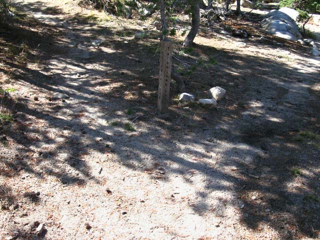
Trail Sign
at the
Top of Spicer Meadow Reservoir
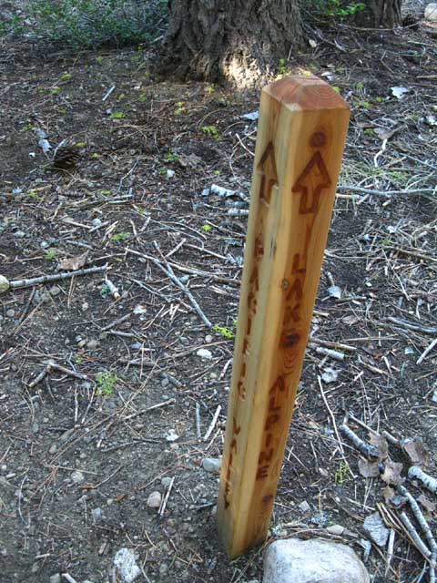
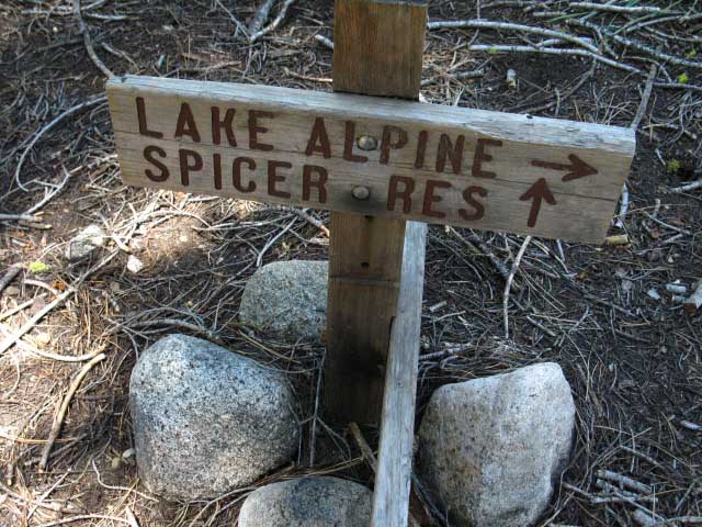
A short ways South of the Pacific Valley Trail junction above we encounter a trail sign post without a trail junction. This sign post is situated just before our entry into Highland Canyon, and is located here mostly to inform Northbound backpackers coming out of Highland Canyon. This post holds two signs, one pointing the way North towards the location of Spicer Meadow Reservoir itself, and around the North side of the reservoir North to Lake Alpine. The sign pointing South (second picture below) directs us South towards Highland Lakes via Highland Canyon past the Sword and Lost Lakes junction located just a bit further South on the Tahoe to Yosemite Trail up Highland Creek. Heading South up Highland Canyon offers us interesting hiking options. Below: Northbound hikers reach Spicer Meadow and look North to Lake Alpine. |
||
 |
||
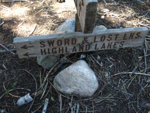
Camping at Sword and Lost Lakes The bottom sign on this post (below the map below) is pointing the way South down the Tahoe to Yosemite trail towards the upcoming Sword and Lost Lakes trail junction. The Sword and Lost Lakes trail runs Southwest off of our Tahoe to Yosemite Trail route to roughly parallel the South shore of Spicer Meadow Reservoir to Sword and Lost Lakes. Turning Right at the Sword and Lost Lakes junction would circle us around to the South shore of the Reservoir, where we can continue South past this pair of lakes around the Southwest shoulder of The Dardanelles to the rather remote dirt road access up to the County Line Trailhead, coming up from Highway 108 via Clarks Fork Road. The Quickest Way In to Sword and Lost Lakes: From the South Take the Clarks Fork Road off of Highway 108 to quickly turn Left towards the French Creek Campground, but continue past the campground along Road 6N06 to the parking and trailhead at County Line Trailhead. A 2.27 mile trail around the Western edge of the great Dardanelles volcanic formation links the trailhead at County Line with Sword and Lost Lakes. From Sword and Lost Lakes you can easily hike Northwest up to the Tahoe to Yosemite Trail at the top of Spicer Meadow Reservoir. Click the Map for Full Sized Topo Hiking Map Above: Heading North up to Sword and Lost Lakes from trailhead off of Highway 108. Full Credit to The USGS for their fine Topo Maps, in this case the Spicer Meadow Reservoir map. See the full sized Sword and Lost Lakes topo map, and the large scale Carson Iceberg Wilderness Topo Map to put this map section into context, and the google road map on the Kennedy Meadows Pack Station page shows us how to find Forest Road 6N06 from the Clarks Fork Road off of Highway 108. Scroll the Road Map a bit West to find the Clarks Fork Road. I found the NGS Data Sheet Dardanelle Cone, which gives a 1956 description of the route up to the top of Dardanelles Cone from Highway 108. Note the later descriptions basically say, "Fly a helicopter in." The old pre-helicoptor USGS dudes must have been hardcore!
Continuing South We continue our hike South up Highland Creek past the Sword and Lost Lakes sign towards the Jenkins Canyon trail junction where the TYT turns South out of Highland Creek. There we have a decision. At Jenkins Canyon we have the option of continuing up Highland Creek to Highland Lakes and road access there, and continuing past Highland Lakes through the Gardner Meadow Trailhead to meet up with the Pacific Crest Trail at Wolf Creek Pass. Or we turn South following the TYT up Jenkins Canyon. |
||
 |
||
Approaching the South Side of the Carson Iceberg Wilderness on the Tahoe to Yosemite Trail: Highway 108 Note that the Sword and Lost Lakes trail down the South shore of Spicer Meadow Reservoir continues South past the Sword and Lost Lakes and on through the remote County Line Trailhead onto dirt road access down to Clarks Fork Road off of Highway 108. Our hike South along the Tahoe to Yosemite Trail route has now brought us to close road access through trailheads off of Highway 108, the Sonora Pass Road, than our Highway 4 trailhead to our North. We'll get closer yet. Crossing over Jenkins Canyon into Woods Gulch will quickly bring us down to Arnot Creek and downstream through its trailhead onto the old paved Clarks Fork Road off of Highway 108. We won't just have road access, our TYT route follows the road itself. The Clarks Fork Paved Road and its campgrounds and various facilities are very busy during Summertime. This means that we should be able to get a ride out of here if we have to bail out... and the Clarks Fork Road connects with Highway 108 just a few miles West of Kennedy Meadows Pack Station. It may take a while. The folks camping up here are Valley Folk. They would not give us a ride across the Valley getting out here, and they won't give us a ride out of here either. I've hitched in California for the past 42 years, and nationally for 40. Hitching in California in 2014 is the same as hitching across Utah in 1974. That, my friends, is a sad statement. Our Southbound direction along the Tahoe to Yosemite Trail requires we follow the arrow to Highland Lakes on the trail sign above, and continue South, ignoring the Sword and Lost Lake trail junction. Pointing us to Highland Lakes continues us up Highland Creek, which brings us to our TYT Jenkins Canyon trail junction. At the Jenkins Canyon junction we have a choice. We will either follow the Highland Creek Trail up to Highland Lakes and the PCT beyond, or we will follow the Tahoe to Yosemite Trail South through Jenkins Canyon.
|
The Actual Sword and Lost Lake Trail Junction
Sword and Lost Lakes Trail Junction Following the Tahoe to Yosemite Trail a short ways South up Highland Creek past the irrelevant signpost (above) at Spicer Meadow Reservoir quickly brings us up to the actual Sword and Lost Lakes trail junction, pictured below. |
| The trail to Sword and Lost Lakes heads Southwest off the Tahoe to Yosemite Trail just a short ways South of the top, the Northeast side of Spicer Meadow Reservoir. | ||
 |
||
The top sign on this post is facing South, directing Northbound backpackers on their way to Sword and Lost Lakes to hike to their Left, to the Southwest. The top sign also points the way North towards Spicer Meadow Reservoir and on to Lake Alpine. Northbound Loops Note the possibilities for Northbound loops out of the Arnot Creek Trailhead from Clarks Fork Road to Spicer Meadow Reservoir via Jenkins Canyon. From Spicer we can head South to visit Sword and Lost Lakes on our way to end an "almost" loop route at County Line Trailhead, also off of the Clarks Ford Road... Sword and Lost Lakes Topo Map The lower sign on this post faces North, directing Southbound backpackers to continue our Southbound hike up Highland Canyon towards the Jenkins Canyon trail junction where the Tahoe to Yosemite Trail turns South up Jenkins Canyon. The Highland Creek Trail continues Northeast past the Jenkins Canyon trail junction up to Highland Lakes where we find the Gardner Meadow Trailhead just beyond the lakes, and the PCT a couple of miles further down the trail through the Gardner Meadow trailhead: Spicer Meadow Res to Highland Lakes and PCT But, we of the TYT are continuing South on the Tahoe to Yosemite Trail into Highland Canyon to turn Southeast up Jenkins Canyon.
|
Hiking around the exposed Peak 7635 into Highland Creek
Turning around to look Northwest, down-mountain towards Spicer, as we hike into Highland Creek Canyon. Not too bad of a climb up, out of Spicer. |
 |
Looking back the way we've hiked up from Spicer Meadow Reservoir. Let's turn around and take a look at the mouth of the upper canyon. |
Peak 7635
| Looking Northeast, to our Left, at the exposed rock of Peak 7635 behind Spicer Meadow Reservoir as our trail bends around it to hike up into Highland Creek's Canyon. We were looking at this terrain when we crested the ridge above Spicer Meadow Reservoir. |
||
 |
||
Peak 7635 is the exposed peak we identified rising behind the end of Spicer Meadow Reservoir from the high point of the trail where we first got an overlook of Spicer Meadow Reservoir. Now we are hiking into Highland Creek Canyon around its Right (South) flank from our perspective hiking South into Highland Canyon.
|
Peak 7635
| Hiking around the exposed rock of Peak 7635 behind Spicer Meadow Reservoir. |
 |
To the Left of our Southbound Tahoe to Yosemite Trail route is this exposed peak, Peak 7635, and to our Right is Highland Creek. We make our way through the narrowing gap between them up towards the Jenkins Canyon trail junction. The trail bumps up here, leaving Highland Creek in a narrow channel to our South, for the hike into the mouth of the canyon. The trail and Highland Creek draw closer together after we cross the high point of the trail passing around Peak 7635. Spicer Meadow Reservoir to Clarks Fork Road |
Highland Creek South
to
Jenkins Canyon Trail Junction
| VIDEO A very pretty part of our hike. |
||
Duration: 3:39. Spicer Meadow Reservoir to Highland Lakes
|
East-Northeast up Highland Creek's Canyon
| Eastbound View: Over the rise, then down to the Jenkins Canyon trail junction. The Jenkins Canyon junction is just over and beyond this rise, located where the forested ridge descending from the Right-Center of the image comes down to Highland Creek... Not Far... |
 |
Highland Creek is to our Right, running parallel to our trail, the barren peak sits to our Left. |
Back Down to Highland Creek
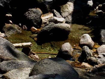
| Placid waters of Highland Creek during July. | ||
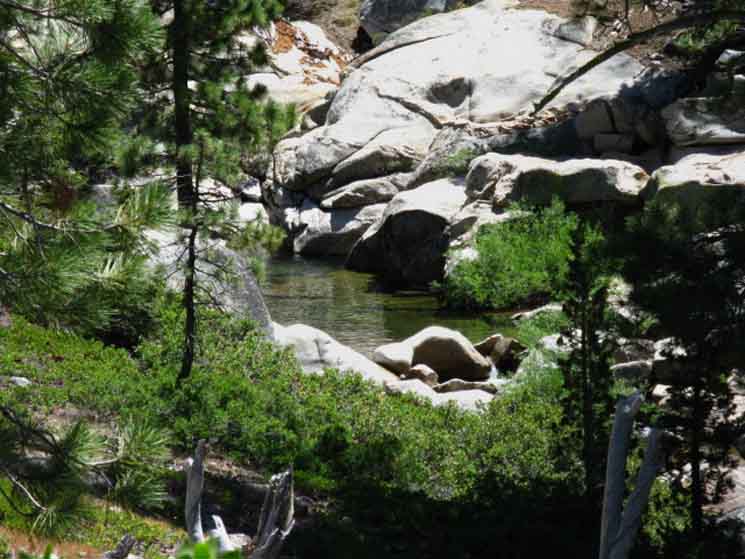 |
||
Sweet Highland Creek There's a stretch of Highland Creek that runs through a deeply shaded narrow channel from where we return to the creek up to and past the Jenkins Canyon trail junction. This channel is lined with strikingly water-sculpted granite, which attests to the force of water running through here for thousands of Spring Thaws after the glacier that cut the original line of the canyon withdrew. Thousands of years of erosion has "finish carved" the already beautiful glacial-cut granites in here. Call it a section of master works of hydraulic sculpture. The result is a series of pools set within great blocks of beautiful granite, well shaded, peaceful and calm. Well, at least after the main force of the Spring Thaw has passed down the mountain. One cannot ignore the message of violent power the sculpted granite imparts: Spring flows through here are powerful enough to carve rock into the gravestones of any folly encountered. Don't be foolish here when the powers of nature are surging!
|
Everything about the trails is in motion...
| Dead blaze heading up Highland Creek. |
 |
This old blaze echoes the ambient feeling of impending isolation-deepening isolation- one experiences entering Highland Creek's Canyon. The signal given by the dead blaze above is that man's footprints on the terrain are fading into oblivion, which is true in one way, and false in others. True, in that trails here are maintained at the fringe of viability. We've noted the moderate challenges of following the faded route of the TYT South across the burned area from the North fork of the Stanislaus River to our overlook of Spicer Meadow Reservoir. The "new" work and configuration of the trail and junctions at the top of Spicer Meadow Reservoir reassures that the Stanislaus National Forest is keeping up the trails, which is true in a way. Most of the trails across the Stanislaus National Forest are what the Forest Service calls "infrequently maintained trails." I'd go as far as saying that we should assume that all of the trails across the Carson Iceberg, in both the Stanislaus and Toiyabe administered areas, are "infrequently maintained." For instance, although the trail up Highland Creek above the Jenkins Canyon trail junction to Highland Lakes is marked as "maintained trail" on the 2009 Forest Service Map, I've found it to be a faint track that fades into the terrain for short lengths once we get above Hiram Meadow. 2009 National Forest Map pdf After speaking to many hikers and doing many backpacking trips across remote areas of the Carson Iceberg Wilderness I've come to the conclusion that all hikers off of the PCT ("the superhighway of trails"), and away from the main Carson Iceberg Wilderness trailheads should expect to encounter faint trail conditions, especially along the route of the TYT. This is not the fault of the Stanislaus National Forest. Their trail crews do a great job with the sparse resources they have to cover a vast area of responsibility. Keep your Eyes Open!! |
| Preceding the Jenkins Canyon Trail Junction we enter a section of Highland Creek's water-sculpted granite. |
Highland Creek Granite
| The trail runs down close to the sculpted granite in Highland Creek. |
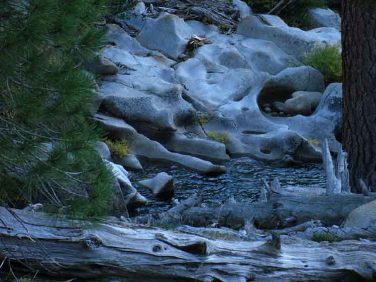 |
Waves of granite first cut by glacial ice, the subsequently ground and polished by the hydraulic power of sandy soil-rich waters surging down the canyon during the Spring Thaw. |
Highland Creek Granite Detail
| The sensual and strange shapes of Highland Creek Granite. The granite has been both formed into waves and arches, and then polished by the sand-rich runoff to a smooth finish. | ||
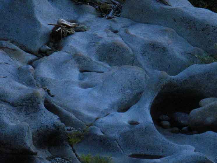 |
||
There's a couple of nice campsites along this stretch of trail alongside great swimming holes.
|
Highland Creek Granite Arch
| Great granite arch along Highland Creek. | ||
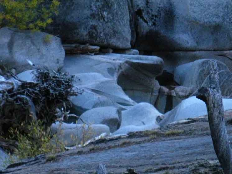 |
||
This section of Highland Creek, where it's squeezed through this narrow granite channel, has a special beauty. Alright, this generation of "digital backpackers" must have better pictures of these stunning granite formations than I. Post up some killer images of this amazing segment of Highland Creek, or email me the images, and I'll post them.
|
Jenkins Canyon Trail Junction
| This is the the new trail junction post (2011) where we Southbound hikers on Tahoe to Yosemite Trail turn South, Right, up Jenkins Canyon. |
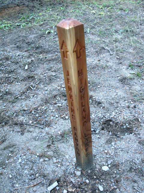 |
Unless we are breaking off an alternative route, or even swinging a big loop around the Carson Iceberg. Then we hike up Highland Canyon. Southbound hikers on the Tahoe to Yosemite Trail make a Right here, to depart Highland Canyon up Jenkins Canyon, on our way over to Clarks Fork Road off of Highway 108.. |
Trail History
The Old Jenkins Canyon Trail Junction
(The Sinage before the post above was installed)
| The old Jenkins Canyon Trail junction. | Upper sign on the old Jenkins Canyon trail junction. | |||||
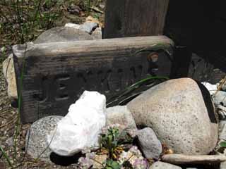 |
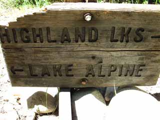 |
|||||
The new post above replaced this post with its signs. |
We have seen that the Stanislaus NF has worked over their trail junctions signage around the upper end of Spicer Meadow Reservoir. |
North TYT: Lake Alpine to Rock Lake. NE to PCT via Highland Creek and Lakes. South TYT: Jenkins Canyon to Boulder Creek.
Tahoe to Yosemite Trail |
||
Lake Alpine to Saint Marys Pass Notes on the Trail Junctions at the top of Spicer Meadow Reservoir We can consider the trail junctions on the North side of Spicer as the center of a hub of trails radiating out across the Northwest Carson Iceberg Wilderness to all compass points. This is the key trail junction for a whole series of loops out of the Silver Valley, Highland Creek, and Clarks Fork Trailheads, backpacking loops that take us on around the Northwest Carson Iceberg Wilderness. Spicer Meadow Reservoir can be the destination of short in and out backpacking trips from any of the above-mentioned trailheads, the turning point of longer looping backpacking loops, or a quick stop for the through-hiker on a long distance trip down the Tahoe to Yosemite Trail. The sweet campsites make it a nice overnight spot, if it fits our hiking plan. This is because the junctions at the top of Spicer Meadow Reservoir act as the hub for the trailheads circling its location. To our Northwest is the Silver Valley Trailhead at Lake Alpine, to our North is the Pacific Valley Trailhead near Pacific Grade Summit on Highway 4, to our Northeast sits the Highland Lakes Trailhead, to our East the Arnot Creek Trailhead sits along the Clarks Fork Road off of Highway 108, and to our South we have the remote County Line Trailhead via Sword and Lost Lakes, also off of Highway 108. Our loops here overlap with the next series of loops we can hike out of the South-central trailheads along Clarks Fork Road, and make a gradual transition to South Carson Iceberg backpacking loops, which get harder, and possibly longer, as we hike South. We are circled by trails leading in all directions from the top of Spicer Meadow Reservoir, from which we can craft a bunch of short and medium distance backpacking trips across this "hub" junctions at the top of Spicer Meadow Reservoir. We can pick our trailhead in--We can pick our trailhead out, and will hike through the top of Spicer Meadow Reservoir as the mid-point between the beginning and end of our trip, if its looping around or trailhead to trailhead.
Topo Maps 7.5 Minute Topo Hiking Map 30 min Topo Hiking Map |
Backpacking Trail Guide North |
|
Northeast Jenkins Canyon |
Backpacking Trail Guide South |
Backpacker ForumsHave a great Sierra Nevada trip or story to relate? A fine piece of gear? Or gear that failed?Post it on
|
North TYT: Lake Alpine to Rock Lake South TYT: Jenkins Canyon to Boulder Creek
Trailhead
Contact
Alex Wierbinski

Backpacking Lake Tahoe to Mount Whitney
Your Guide to the High Sierra Crest, including the Tahoe to Yosemite, Pacific Crest, and John Muir Trails
