


Hiking
Kennedy Meadows Pack Station
to
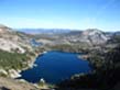
Relief Reservoir
and into
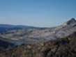
Emigrant Wilderness
BACKPACKING MAP
The
Tahoe to Yosemite Trail backpacking across Emigrant Wilderness
Six 7.5 minute USGS Topographic Backpacking Maps
Maps |
TYT |
TYT |
Miles |
Trail Guide |
Trail Guide |
BIG |
SIERRA CREST |
Click RED DOTS for Trail Guide Pages |
Trail Guide INDEX |
all maps |
Weather |
Resupply |
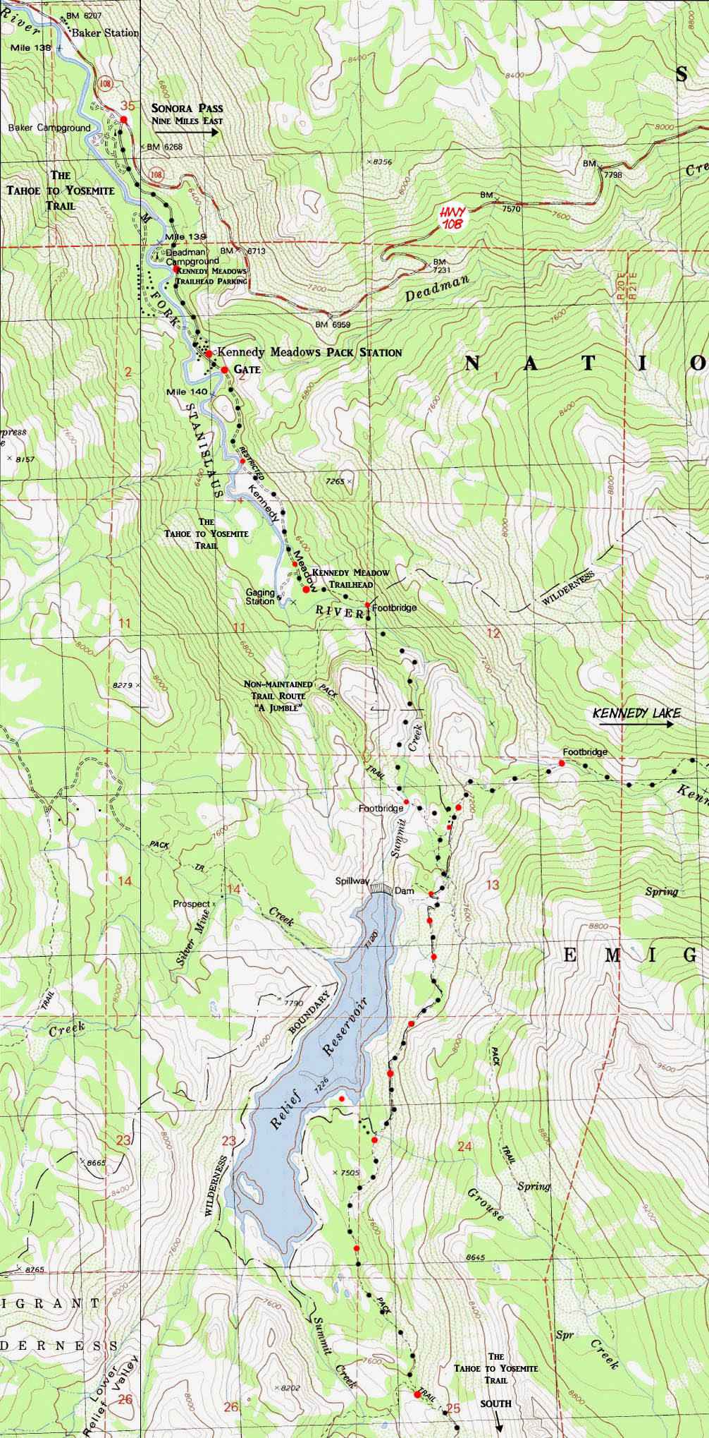
Kennedy Meadows to Relief Reservoir
Backpacking Topo Map
| 4.03 miles |
7.06 miles | |
| Kennedy Meadows Pack Station South Gate to Relief Reservoir Campsites |
Kennedy Meadows Pack Station South Gate to Kennedy Lake Campsites |
| 10.92 miles |
| Kennedy Meadows Pack Station South Gate to Brown Bear Pass |
Click
Map Labels Pointing to Adjacent Topo Maps
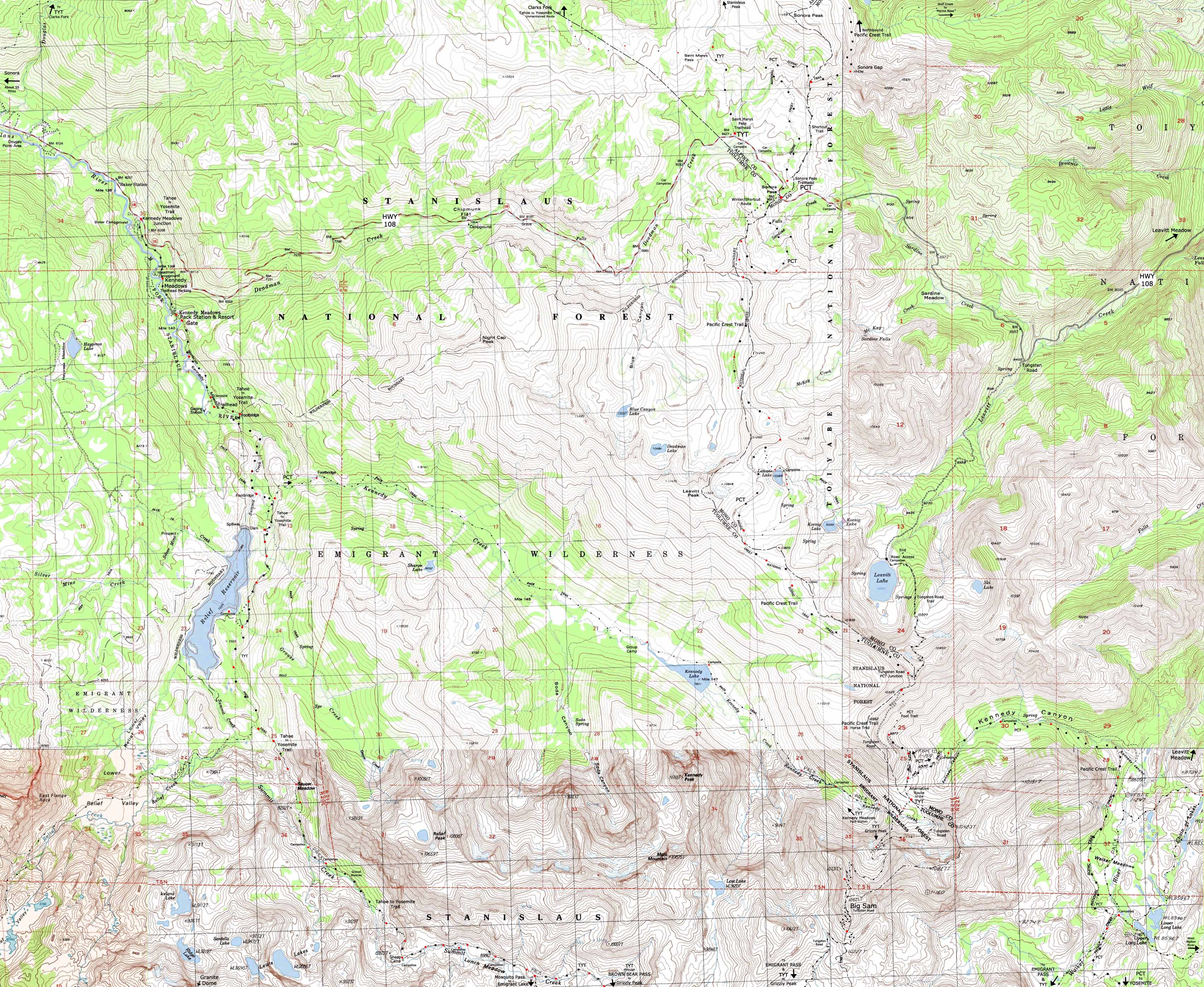
| Map NORTH Sonora Pass Area Trails |
Map Click Red Dots
|
Map EAST to PCT Kennedy Lake to Kennedy Canyon |
Relief Reservoir,
The Tahoe to Yosemite Trail,
and
Highway 108
|
| Map NORTH Sonora Pass Area Trails |
ABOVE Map |
Map EAST Kennedy Lake to Kennedy Canyon |
| The Trails Come Together at, and diverge from, Sonora Pass: 30 minute Carson Iceberg & Emigrant Wilderness High Altitude Trail Map |
| Map NORTH Sonora Pass Area Trails |
Map Click Red Dots |
Map EAST Kennedy Lake to Kennedy Canyon |
The PCT,
&
The Tahoe to Yosemite Trail,
ALL pointing to Convergence in
The Northwestern Corner
of
Yosemite National Park
|
| Map NORTH Sonora Pass Area Trails |
MAGNIFY THIS MAP! Map |
Map EAST Kennedy Lake to Kennedy Canyon |
30 minute Carson Iceberg & Emigrant Wilderness High Altitude Trail Map
Map and Location NOTES & INFORMATION |
||||||
Main Features The map features the Highway 108 corridor trailheads. Local Destinations Off the TYT South on the TYT Another 1.34 miles past Relief Reservoir brings us a total of 5.37 miles South of the Kennedy Meadows gate to the trail junction above the Southeast shore of Relief Reservoir. Here the trail splits, with the trail Southwest leading up to Lower Relief Valley on the way over to Relief Valley. Beyond the Loco Once we get up to the Sierra Crest we have to decide where to go next. North towards Sonora Pass? Hikers into the Emigrant Basin through Brown Bear Pass can hike North over Big Sam to return to Kennedy Meadows via Kennedy Lake. We can see many fine "lollypops," trailhead to trailhead, and grand backpacking loop possibilities in the web of interconnected trails stretched across the Emigrant Wilderness. Map Updates and Information The first is between the lower and upper footbridges just South of the Kennedy Meadow Trailhead. Marty is one of Matt Bloom's professional backcountry horsepackers and an all-around knowledgeable hand on High Sierra travel, trails, and terrain.
Marty: "It's a Jumble."
Map Correction #2 Above and South of the upper footbridge the trail splits between two short route options which rejoin on the flat above the upper footbridge. This short trail split is fairly inconsequential, but from the flat where the two trails rejoin above the bridge the trail South is different from the USGS map's depiction. The trail South first encounters the Kennedy Lake trail junction, then the now-empty site where PG & E's Relief Cabin once sat. I have depicted the current route as of July 2012 as best I can on the map above. Map Problems Solved above TYT Trail South from lower to upper footbridges along Summit Creek. TYT Trail route to above upper footbridge to the Kennedy Lake trail junction.
Mapology What's important for our general reference purpose is that each side of a square is 1000 meters, or a Kilometer. From my point of view that is 1093.6 yards or .62 of a mile. Diagonal: 1414.22 meters, if my trig is correct. That converts the diagonal distance into 4,639.8 feet or .88 of a mile.
top of page |
North Sierra Road Map
Mapping, Mileage, and National Forest Information |
|||
Miles Kennedy Meadows Gate to Kennedy Lake trail junction 2.67 miles Kennedy Meadows Gate to Kennedy Lake trail junction 2.67 miles Kennedy Meadows Gate to trail junction on Southeast side of Relief Reservoir 5.37 miles
Miles and Elevations |
USGS Topo Hiking Maps Northwest Map North-Middle Map Northeast Map
Southwest Map South-Middle Map Southeast Map Central Point
Backpacking permitting authorityStanislaus National Forest Wilderness Contacts National Forest Wilderness Area information: Emigrant WildernessRanger District Under the Dardanelles Cone Geological feature between Highways 4 and 108 on the Western Flank of the Sierras. |
||
TYT Topo Map NORTH Sonora Pass Trailheads TYT Topo Map SOUTH Relief Reservoir to Brown Bear Pass
| Elevations | More Information | ||
Kennedy Meadows Pack Station Relief Reservoir Brown Bear Pass |
Trail Guide, Section: Highway 108 to 120 Trail Guide, Trailheads: Sonora Pass Trailheads into Carson Iceberg and Emigrant Wilderness |
||
Map Credit |
||
U.S. Geological Survey, Department of the Interior I love the USGS, as you can see from the Tahoe to Whitney Maps. I also dig the NWS, as you can see from our Weather Page. We gotta know the terrain under our feet, and the weather in the sky. These are the basics. In that spirit, let's set you up with the USGS maps sufficient to plan and execute your High Sierra Backpacking Trip with a set of custom backpacking maps. In fact, we can use the USGS to set us up to plan and hike anywhere in the US of A. Move the Map to the Sierras. Or your favorite backpacking spot in the US of A. Navigate the map to the area you wish to locate maps. Click "Mark Point" in the options to see the USGS map grid of the various scaled maps. Select the maps that will help you plan and execute your backpacking trip, set up a directory on your computer named for the trip or location of the maps, and begin downloading those suckers. Open your USGS maps with Adobe Reader. But first, we have to "unzip" the maps. I use 7zip. Custom Maps Printing At least one reader of Tahoe to Whitney has copied and printed out Tahoe to Whitney Maps with success.
That is totally cool for personal and non-profit uses. |