The Trails
Guide
Maps
Miles/Ele
Permits
Resupply
Forum
Current Weather Conditions
Weather Notes
Northern High Sierras
Central High Sierras
Southern High Sierras
Gear
Gear List
Gettin Started
Layering
Discussion
Testing yourself and your gear
Gear Reviews
Tuolumne Meadows to Reds Meadow
On The
John Muir Trail
Miles and Elevations
Backpacking
South Yosemite
into the
Northern
Ansel Adams Wilderness
Backpacking
Miles and Elevations
on the
John Muir Trail
to our
Reds Meadow and Mammoth Lakes
Rest & Resupply Points
Languages
Translate
Trail Arts
The art of walking
Physical Preperation
Trail Skills
The trail
Off the trail
Scrambling
Maps
Navigation
Camp skills
Food
Resupply
Food
Other
Photo Catagories
Trail Stories
Trail Culture
News and Science
Links
Groups
Books
MILES TYT-PCT |
MILES JMT |
MILES JMT-PCT |
MILES ALT-ROUTE |
MILES ALT-ROUTE |
MILES JMT-PCT |
REGIONAL JMT-PCT |
|
Local |
ALL
TRAIL |
|
Yosemite and Ansel Adams
Wilderness
Miles & Elevations
Unified Trail
3 Routes
Two Other Routes
PCT: 1000 Island Lake to Agnew Meadows
River Trail: 1000 Island Lake to Agnew Meadows
Below
JMT |
| Location | Elevation | Mileage | |
| Tuolumne Meadows Ground Zero Store, Grill, & P.O. |
8591 | 0 | |
| +29 | .51 | ||
| End of Campground Road Trail to Southbound JMT |
8620 | .51 | |
| +20 | .10 | ||
| John Muir Trail JMT bypass around Tuolumne Meadows Mileage Sign Posts North & South JMT |
8640 | .61 | |
| +30 | .82 | ||
| John Muir Trail to Toulumne Lodge Footbridge to Tuolumne Meadows High Sierra Camp, Tuolumne Lodge. |
8670 | 1.43 | |
| +10 | .64 | ||
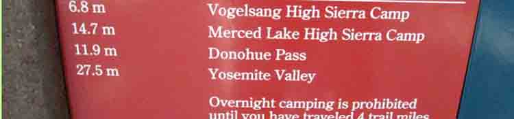
| Rafferty Creek Junction Tuolumne Pass: Quick way to Vogelsang HSC |
8680 | 2.07 | |
| +221 | 4.17 | ||
| Vogelsang HSC-Ireland Lake Junction Another route to Yosemite Valley |
8901 | 6.24 | |
| +99 | 2.88 | ||
| End of Lyell Canyon, Lyell Creek Now we Climb |
9000 | 9.12 | |
| +640 | 1.06 | ||
| Footbridge | 9640 | 10.18 | |
| +160 | .30 | ||
| 9800 | 10.48 | ||
| +400 | .6 | ||
| Sites at first ford-Lower Basin, & Sites along Lyell Creek (mile 169 Mark) |
10200 | 11.08 | |
| +280 | .66 | ||
| Over & Down to Second Ford Upper Basin & Sites along Lyell Creek |
10480 | 11.74 | |
| +240 | .45 | ||
| Climb to bend in Trail to see Third Sites above Upper Basin, Conness to the North, Lyell Canyon laid out Below | 10720 | 12.19 | |
| +320 | .5 | ||
| Blue Drop Lake on Top of Donohue Pass, PARK BOUNDARY Exiting Yosemite, entering Ansel Adams Wilderness |
11040 | 12.69 | |
| +0 | .01 | ||
| Sloppy little Pond on Donohue Pass |
11040 | 12.70 | |
| -560 | .83 | ||
| Arrive Top of Rush Creek Enter A Quite Enchanting Zone of fine sites |
10480 | 13.53 | |
| -408 | 1.68 | ||
| Marie Lakes Junction Sign Post |
10072 | 15.21 | |
| -459 | .73 | ||
| Rush Creek Trail to Waugh, Gem, and Silver Lakes Sign Post |
9613 | 15.94 | |
| +85 | .43 | ||
| Davis Lakes Junction Sign Post |
9698 | 16.37 | |
| +505 | .99 | ||
| Island Pass |
10203 | 17.36 | |
| -360 | 1.72 | ||
NE Shore of 1000 Island Lake Southbound The PCT runs NE off the line of JMT, first accessing top of the River Trail. RT runs down along the Middle fork of the San Joaquin (a shaded, soft trail down to Agnew Meadows). Pacific Crest Trail Route Miles PCT stays high to bend Southeast onto the barren, exposed volcanic East Wall of the canyon, before descending to Agnew Meadows. The JMT moves South in the complex granite and forest terrain cut into the West Wall of the Middle San Joaquin Canyon before descending down to Devils Postpile, then Reds Meadow. Those are our three trail options down to or up from Reds Meadow from here. SOUTH JMT |
9843
|
19.08
|
|
| +66 | .52 | ||
| SE corner Emerald Lake | 9909 | 19.60 | |
| +xx | .35 | ||
| Ruby Lake outlet creek |
9911 | 19.95 | |
| -233 | 1.22 | ||
| Garnet Lake Footbridge-Junction Campsites Trail 1.16 miles East down to River Trail along Middle Fork San Joaquin River |
9678 | 21.17 | |
| +427 | .63 | ||
| Top of Ridge Dividing Garnet Lake from Shadow Creek |
10105 | 21.80 | |
| -1115 | 1.70 | ||
| Ediza-Shadow Lakes Split JMT & Shadow Lake Left, East & down. Ediza Lake Right, up to the West. |
8990 | 23.5 | |
| -253 | .67 | ||
| Shadow Lake Split JMT Right, South River Trail 1.61 miles East Ranger White Boards Mileage Sign Post |
8737 | 24.17 | |
| +646 | 1.29 | ||
| Rosalie Lake Outlet | 9383 | 25.46 | |
| +131 | .71 | ||
| South Shore Gladys Lake | 9514 | 26.17 | |
| -196 | 1.86 | ||
| Castle Lake Junction | 9318 | 28.03 | |
| -1182 | 2.77 | ||
| Johnston Meadow Junction | 8136 | 30.8 | |
| -656 | .67 | ||
| PCT-JMT Junction Mileage |
7677 | 31.47 | |
| -131 | 1.39 | ||
| Footbridge Devils Postpile | 7546 | 32.86 | |
| +174 | 1.39 | ||
| End of Minaret Road, Reds Meadow Mileage |
7720 | 34.25 |
TYT-PCT
|
|
| JMT NORTH Tuolumne Medows to Yosemite Valley Miles and Elevations |
JMT SOUTH Reds Meadow to Vermilion Valley Miles and Elevations |
Miles
|
| top of page |
Miles North: Sonora Pass to Tuolumne Meadows Miles South: Reds Meadow to Vermilion Valley Resort
Notes Setting up the outlines of the South Sierra section of Stay tuned for construction progress. |
Miles and Elevations |
ahoe on H |
Backpacker ForumsHave a great Sierra Nevada trip or story to relate? A fine piece of gear? Or gear that failed? Post it on Above we come to the Front Page of the High Backpacking Trails and Topics Forums. Below we break the forums down into categories:
The Trails Forum acts as your place to put up input, comments, relate your experiences, or ask questions about each segment and spot along the length of our combined TYT-PCT-JMT trails. The Forum is your place to supplement the trail guide. Anyone can post text comments in the existing forums, but only members can post up new topics, along with images, maps, and formatting. If you have experiences, comments, questions, or pictures and videos of the John Muir and Pacific Crest Trails Vermilion Valley to Muir Ranch, post up here as an unknown hiker or as a member: UNDER CONSTRUCTION Forum Section
|
Miles North: Sonora Pass to Tuolumne Meadows Miles South: Reds Meadow to Vermilion Valley Resort