High Sierra
Backpacking
Trail Guide
Forums
Sierra
Weather
WeatherNotes Northern
Sierra Weather
Gear
The Tahoe to Yosemite Trail
Meeks Bay Trailhead
Local
Backpacker Resources
The Second Page of the Tahoe to Whitney Trail Guide
Hiking Desolation Wilderness
Languages
Trail Skills
Mountain
Safety
Food
Planning
Trail Arts
More
Information
Social
| Trail Guide INDEX Section Index |
|
PREVIOUS |
NEXT |
Topo Backpacking MAP Meeks Bay to Dicks Pass |
Miles & Elevations Meeks Bay to Echo Lake |
All SIERRA MILES INDEX |
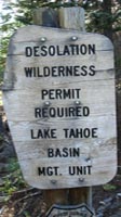
PERMITS Lake Tahoe Basin Management Unit PERMITS |
All |
Meeks Bay Trailhead
|
|||||||||||||||||||||||||
| Meeks Bay to Dicks Pass 15 minute Backpacking Map |
Desolation Wilderness 30 minute Backpacking Map |
Meeks Bay to Echo Summit
Backpacking Miles and Elevations
Meeks Bay Trailhead
INDEX
Backpacker Resources
and
Hiker Information
| This page considers the sparse resources near the Meeks Bay Trailhead. Arrive there with what you need. |
| On this page | |||||||||||||||||
Meeks Bay
Tahoma
Meeks Bay
South Lake Tahoe
Google Road Map
Trail Guide
Meeks Bay Resources Discussion |
Weather, Road and Fire Information Below find the closest Ground Stations, Point and Regional Forecasts along the West shore of Lake Tahoe. Satellite and Radar Imagery provides Long Range and Regional overviews.
All Weather and Fire Information |
||||||||||||||||
| >Backpacker's Forum < | |||||||||||||||||
The Tahoe to Yosemite Trail
FORUM
All backpackers can post text comments, questions, and are invited to share their experiences in this Meeks Bay to Echo Lake section of trail, or post up here about your knowledge of local backpacker resources through the comments links on this page.
Post what you know about Sierra Trails on the
Tahoe to Yosemite Trail backpackers Forum.
Registered Members can post up text, images, maps and videos in the Trails Forum that supplements and updates the trail guide's coverage of the trails all the way down to the Whitney Portal.
Share the important and interesting things you experience.
Check out the Tahoe to Whitney .org Backpacking Trails and Topics forums to review the upcoming trails, and what we will need to hike them.
| Tahoma Store and Deli |
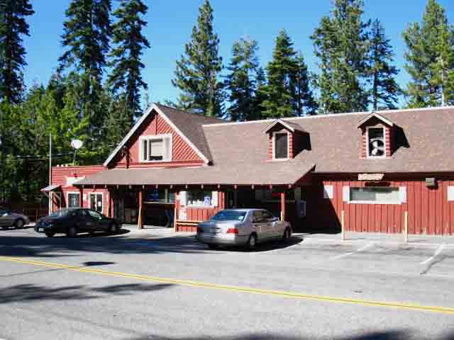 |
PDQ STORE in TAHOMA The folks in here were Eastern Euros recently transplanted to the West Shore of Lake Tahoe in '09. They were nice folks. The Deli Sandwiches were great in 2009. How are they Now?
|
The Tahoma Store and DeliTahoma is a small town located about 4 miles North of the Meeks Bay trail head. It is the nearest place for resources of any substance whatsoever. The Tahoma Store's deli makes huge sandwiches on fine bread, and has most of what you will need for a picnic lunch. They have a small grocery store as well. A bit South of the Tahoma Store there is a tiny shopping center on the West side of the road that has a pizza parlor. It is behind us from the perspective above. I had a few pieces in 2009. It was pretty good. That's about it for Tahoma! Additions? |
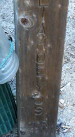
Tahoe to Yosemite trail post just South of the Meeks Bay Trailhead. This is one of two signs that mention the TYT down the whole TYT trail. |
Details-DetailsIf you are driving in, you can easily access the food resources at Tahoma. If you are hitching, it may be hit or miss. I always like to feed-up before hitting the trail, so this is important to me. It stretches out my food supply! If you forgot anything, broke anything, or need any gear or food, your last chance to get it will be in Tahoe City or South Lake Tahoe. The semi-isolated location of Meeks Bay means I'm likely going to arrive late in the day at the trail head, the way I travel. Anticipating delays of our arrival time at the trailhead in our plans is wise. This will affect how far we can get the first day, which will inject some uncertainty into our trip plan for this first section of trail. |
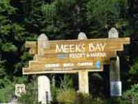
Near the Meeks Bay Trail HeadLANDMARKThe Meeks Bay Resort and Marina
The Meeks Bay Resort and Marina sits 100 yards North of the Meeks Bay Trail Head on the lake side of Highway 89. No trail or hot food, a small convenience store |
South Lake TahoeResources Central In my opinion the center of local resources is 16.2 miles South in South Lake Tahoe. Which location you seek resources from, South Lake Tahoe to the South or Tahoe City to the North, depends on which way you are approaching Meeks Bay. You will get what you need along your approach route to the Meeks Bay trail head, independent of which way you come in. Both Tahoe City and South Lake Tahoe have large grocery stores, If you find yourself stuck at Meeks Bay seeking full resources, I'd head South to South Lake Tahoe. The reasons are many. South Lake Tahoe is located on Highway 50, which is easy hitching East into the Carson Valley or West down to the San Joaquin Valley. Highway 80 sucks. South Lake Tahoe has Amtrack Bus connections both to Reno I find it easier to access Meeks Bay from the South, but the best way for you will depend on the direction you approach the Tahoe Basin. You will find no lack of resources approaching Meeks Bay from the North or South. |
Again, let's look at the google map to Locate
Tahoe City and South Lake Tahoe
|
|
||||||
Now let's check the Topo Maps for a detailed look at the relationship of the Meeks Bay Trailhead to the Highways around the Southwest end of the Tahoe Basin.
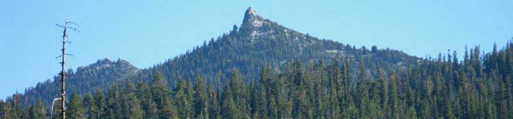
We have the option of using a series of trailheads wedged in along the steep interface between the shining High Sierra rock, the dense dark forests, and sweet blue lake that Highway 89 traces out its route along the Southwestern Shore of Lake Tahoe. The Eagle Falls, Bayview, Mount Tallac, and Fallen Leaf Lake Trailheads South of our Meeks Bay Trailhead provide a series access points to the PCT & TYT route where it crosses the Northern, Central, and Southern parts of the Desolation Wilderness.
The Series Our next trailhead South of Bayview Camp is the Mount Tallac Trailhead overlooking the access points around Fallen Leaf Lake to our South. Access into Desolation Wilderness over Mount Tallac is the highest and steepest way to get into Desolation Wilderness from the North. From Lilly Lake above the Southwestern end of Fallen Leaf Lake we can climb the Glen Alpine trail Northwest into Central Desolation, or we can venture into the Southern end of Desolation Wilderness by hiking South from Lilly Lake up the very steep trail to cross the Desolation boundary in the high mountain gap under Agora and Echo Peaks. The four maps linked to above depict all these trailhead and trail options, even Each of these trails out of the trailheads along Highway 89 South of Meeks Bay begin with a fairly significant Hard 2 degree of difficulty climbing steeply up a total elevation gain of between 1700 to 2000 feet, over very short distances. I rate Glen Alpine as a Hard 3. All of these trails climb to the Tahoe to Yosemite and Pacific Crest Trails, The TYT trail climbing from Meeks Bay to our first potential campsite Our Meeks Bay Trailhead into the North end of the Desolation Wilderness appears to me to be the most gradual access point into the North end of this granite wonderland wrapping around the West Shore of Lake Tahoe called Desolation Wilderness. Gradual also means longer, and ultimately higher. Crossing 8800 feet of elevation over Phipps Pass brings our TYT route higher than any of the other trails out of Highway 89 Trailheads, other than the Tallac Trail reaching 9440 feet climbing over Mount Tallac, and that's not including the spur up to Tallac's 9735 foot peak. Our TYT route crosses 11.5 miles to intersect with the route of the PCT from Meeks Bay. The trails out of the other Highway 89 Desolation Wilderness Trailheads measure between 4 to 7 miles to reach the PCT-TYT running across the center of Desolation Wilderness. But they cover their shorter distance climbing more steeply, while our longer route along the TYT has the luxury of a gentle climb to start with, and a valley filled with lakes, before climbing higher than the other routes from the Highway 89 Trailheads, except the Tallac Trail, to finally reach its junction with the Pacific Crest Trail. Hiking
Click the red dots on the trail maps linked to above that mark the trail junctions along our TYT route leading to the West Shore Trailheads. |
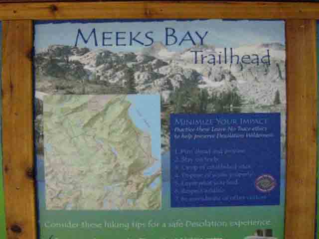
Information Board
at the
Meeks bay Trailhead
This Trailhead Sign Board marks the beginning of our Tahoe to Yosemite
backpacking trip into the Desolation Wilderness
 |
Desolation Wilderness Permits The whole Southwestern Tahoe Basin is very busy during Summertime, not just Desolation Wilderness. The Desolation Wilderness imposes permit restrictions and a zone quota system to determine the number of permits they split 50-50 between advance reservations made up to six months in advance against those held for daily trailhead availability. Thus permits for June can be reserved in January, permits for July in February, and so on. We have our annual backpacking calendar to keep track of these things. One of the benefits of Membership is that I offer the print versions (If I make any) to the members at cost. They are cool and very informative calendars online or on you wall. The link below leads us to the links to the range of LTBMU Desolation Wilderness information, the Sierra Wild information about Desolation, and the Desolation Wilderness permit reservation system through Recreation.gov: I suggest reviewing the LTBMU info first, then the Sierra Wild info before hitting the reservation website. Desolation Wilderness has lots of rules. We can also obtain permits from local Lake Tahoe Basin Management Unit Ranger Stations during the non-reservation times of year. Or if we are gambling that we can get a permit at the trailhead during Summertime. In that case I would call the LTBMU to determine my odds of success. There are also Summertime-only Ranger Stations at Meeks Bay and the To verify the Summer Stations opening dates, hours of operation, and the permit restrictions and limitations at the Desolation Wilderness, check out this collection of Desolation Wilderness and contact information: I suggest contacting the South Lake Tahoe Rangers to arrange a custom permit for our Tahoe to Yosemite or Tahoe to Whitney backpacking trips. For local backpacking permits remaining within the Tahoe Basin we go through the reservation system. Don't try to get a TYT permit to scam the Desolation limits. |
Last Page: Finding Meeks Bay top of page South TYT: The Desolation Trail
Navigating
this
Trail Guide
Indexes Every part of the guide links to every other part. Every Map is an Index Each map is festooned with links to the maps Every Miles Page is an Index Interlinked Information from Tahoe to Whitney Happy Trails! |
Meeks Bay Trail head
Discussion
continued (back)
Meeks Bay Trailhead location,
|
Backpacker Forums Post it on Above we come to the Front Page of the High Backpacking Trails and Topics Forums. Below we break the forums down into categories:
Anyone can post text comments in the existing forums, but only members can post up new topics, along with images, maps, and formatting. If you have experiences, comments, questions, trip reports, trail conditions updates or pictures and videos of the Tahoe to Yosemite/Pacific Crest Trail from Meeks Bay to Echo Summit, post up here as an unknown hiker or as a member: Section
|
Last Page: Finding Meeks Bay South on the The Desolation Trail
Trailhead
Contact
Alex Wierbinski

Backpacking Lake Tahoe to Mount Whitney
Your guide to the High Sierra Crest, including the Tahoe to Yosemite, Pacific Crest, and John Muir Trails
