High Sierra
Backpacking
Trail Guide
Forums
Sierra
Weather
WeatherNotes Northern
Sierra Weather
Gear
Backpacking
Middle Velma Lake
Hiking the Pacific Crest,
TYT, & TRT
Backpacking Desolation Wilderness
Lunchtime!
Languages
Trail Skills
Mountain
Safety
Food
Planning
Trail Arts
More
Information
Social
| Trail Guide Section INDEX |
North |
South TYT-PCT South of Middle Velma Lake |
Trail Miles & Elevations |
Miles & Elevations INDEX |
Lake Tahoe Basin Management Unit PERMITS |
All forest wilderness PERMITS |
Trail Work
on
PCT-TYT-TRT
North of Middle Velma Lake
Down Elevation We have a small drop in elevation, a loss of 160 feet over the .82 miles hiking South from the Tahoe to Yosemite trail junction with the Pacific Crest Trail to Middle Velma Lake. These are our last feet descending from Phipps Pass 8800 high point between Stony Ridge Lake's 7800 feet and Middle Velma Lake's 7920 feet of elevation. A thousand up and almost a thousand down over the 5.7 miles between the two lakes.
Meeks Bay to Middle Velma Lake: 16.83 miles Middle Velma Lake to Echo Lake Trailhead: 16.39 miles Almost exactly halfway.
Meeks Bay to Echo Summit
Our Next Climb At Middle Velma Lake we are at the low point of our upcoming Southbound climb of 1470 feet over the 4.51 miles up to Dicks Pass' 9630 feet of elevation. Dicks pass will be our second pass out of Meeks Bay. But first we are going to have a nice long relaxing break and enjoy the beauty on display along and around the shores and across the waters of Middle Velma Lake.
|
| Middle Velma Lake Trail Information |
||
Desolation WildernessMeeks Bay Elevation
Mileage We are between climbs.
Mileage Our next climb over Dicks Pass is our Last Substantial Climb before (small climb) and an extended descent to Echo Lakes. Add Your Perspective
|
Backpacking
to
Middle Velma Lake
 |
|
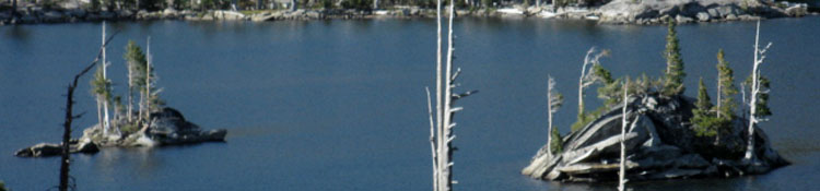
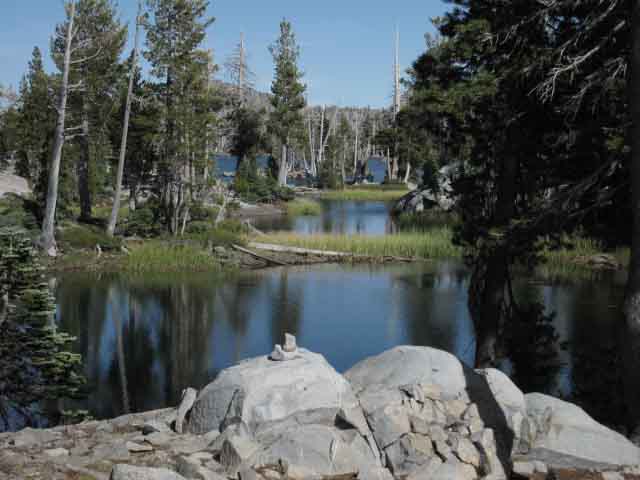
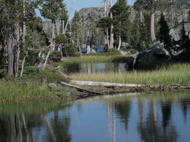
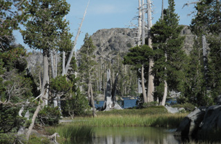
Looking across the seasonal pools emerging from the main body of Middle Velma Lake as water levels drop in Fall. |
|
 |
|
Late season low water forms beautiful pools along perimeter of Middle Velma Lake. Though grassy and moist, there were few mosquitoes during late September. This place is a mosquito production zone during the Spring Thaw. |
|
Some of the crystal blue lakes sitting in Desolation's granite basins divide into scatterings of beautiful blue pools as water levels recede through late Summer into Fall and drop into patterns carved into the underlying granite by various forces of Nature. Lake Aloha is the prime example of this seasonal transition. |
|
Gear Notes |
|
 |
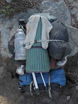 |
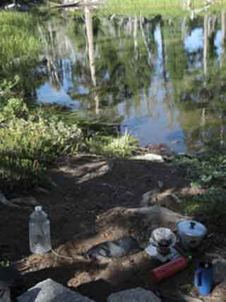
| Time for a hot lunch | My "HOPP," or the Harness Of Pain and Pleasure. Notes on the Rig This is my mobile Joad Wagon. You know, from the Grapes of Wrath. Note the socks drying, shoes hanging off, big second food bag strapped on, the tripod, and the snack bag with today's hiking lunches. It may not be pretty, but it works! Regular Sock changes keep your feet, and your socks, fresh and dry. One pair is always bleaching in the Sun. The trip above carried food for 11 days, and the tripod along with a bunch of trail guide writer gear to make this website, making the pack inhumanly heavy. The two huge external food bag are each holding five days of food, and a Garcia food canister is stashed in the bottom of the pack above the sleeping bag holding another 5 days of food. This rig is tight and does not bounce about on the trail. This rig is secure, and does not fall apart when I wreck on the trail. My sleeping pad is ready to be a seat pad, and the tripod is ready for deployment. |
 |
|
View from my lunch spot.
|
|
Time A few paces off the trail where the trail comes closest to Middle Velma Lake there is a fine lunch/camping site that you will see sitting alongside one of Velma's beautiful pools. These pools were created by the decline in lake level late in the season. Early in the thaw these pools will be submerged, then later they will be bays, and at the end of the Summer they become pools isolated from the main body of Middle Velma Lake by the receding water. The shaded seating around these pools is very relaxing place to have a long break, cook up some food and coffee, rest and re hydrate. My Daily Hiking Plan calls for two lunches. The first is big snacks, consisting of cheese & crackers and dried fruits and nuts. The second lunch is the great feast. I pull out the stove and cook up a real meal to restore all the calories I've burned, and chill out the body for at least an hour. I re hydrate and pump up the water to cover the miles to my next watering hole. |
Gear Notes I've got to pull out the necessary gear and food for lunch. My sleeping pad is first placed by a fine natural rock backrest, to make a very comfortable field chair with a commanding view of the scenery. This will be the center of my gear and food layout: everything will be within reach of this seat. I fill up my water jug, and pull my external food bag off the pack, pictured above. This contains all the snacks and food I will consume on the trail that day, as well as holding a few day's food supply. I carried an 11 day food supply on this trip. I pour enough water into my pan to heat for coffee and soup, then set up the water filter in the jug, also within reach, to pump fresh water as necessary. Notice that I do not filter water at the lake, but use the light plastic jug to bring a load of unfiltered water to my site. I don't filter water that I am going to boil in camp, which is at least half the water I use. It's a complete waste of time and energy to filter all the water we bring to camp. The stove comes out, the water goes on, and I sit down with everything I need within reach for a relaxing lunch. |
North: Pacific Crest Trail /Tahoe Yosemite trail jnct South: South of Middle Velma
The Tahoe to Yosemite Trail |
||
The Pacific Crest Trail backpacker passes directly by a series of pools off of Middle Velma Lake formed by the low level of the Velmas late in the season. The Middle Velma Lake offers a nice place to drink a whole bunch of water, refill the water bottle, make a pack of Ramen Noodles, and have a nice cup of hot chocolate and coffee before continuing down the trail towards Fontanillis Lake, where I was thinking about spending my second night.
Next page South |
Backpacking Trail Guide |
 |
Backpacking Trail Guide |
Backpacker ForumsGeneral Postings Backpacking Topics
Middle Velma LakeAdd your, comments, trips, and pictures about Middle Velma Lake, and your hiking experiences in this area to expand our knowledge of this beautiful location.Do some scrambling about? Exploring? What's up with that? Section
|
North: Pacific Crest Trail /Tahoe Yosemite trail jnct South: South of Middle Velma
Trailhead
Contact
Alex Wierbinski

Backpacking Lake Tahoe to Mount Whitney
Your guide to the High Sierra Crest, including the Tahoe to Yosemite, Pacific Crest, and John Muir Trails
