The Trails
Guide
Maps
Miles/Ele
Permits
Resupply
Forum
Current Weather Conditions
Weather Notes
Northern High Sierras
Central High Sierras
Southern High Sierras
Gear
Gear List
Gettin Started
Layering
Discussion
Testing yourself and your gear
Gear Reviews
Locate
the
South Upper Truckee Trailhead
in
Meyers
Backpacking out of the South Upper Truckee Trailhead in Meyers into the Meiss Country Roadless Area on your way South to Mount Whitney, or just into Meiss Meadow...
Languages
Languages
Trail Arts
The art of walking
Physical Preperation
Trail Skills
The trail
Off the trail
Scrambling
Maps
Navigation
Camp skills
Food
Resupply
Food
Other
Photo Catagories
Trail Stories
Trail Culture
News and Science
Links
Groups
Books
Terms and Conditions of Use
Meyers
South Upper Truckee
Trailhead
 |
||
| The Grand Overview View Southeast from the East side of Echo Summit on Highway 50. That's where we're going.
Let's take a look at our position up here on the East side of Echo Summit from Christmas Valley. |
| On this Page |
||||||||||||||||||
| Trails | ||||||||||||||||||
South Upper Truckee Trailhead
Context
Find the Trailhead
Find the Trailhead
Year Round Trailhead
Local hiking miles Long distance backpacking
New
Trail Culture Local Color
OFF THE PAGE USGS Topo Hiking Map Local |
Lake Tahoe-Meyers
Local Resources
|
|
||||||||||||||||
All Weather |
||||||||||||||||||
| > Forum < | ||||||||||||||||||
Add to the Guide Check out all the Tahoe to Whitney .org Tell us what you see. |
||||||||||||||||||
First,
We've gotta Find
the
South Upper Truckee Trailhead
in
Meyers
Trailhead Location
Google Map |
||||
This road map guides our drive/walk/hitch out to the South Upper Truckee Trail Head. Web Cam Trailhead Directions
|
Let's
|
| 15 min Hiking Map Meiss Country Roadless Area |
30 min Hiking Map Echo Summit to Round Top Lake |
The two mileage pages that lay out the framework of the main TYT-TRT-PCT trails across Meiss Country Roadless Area are
| Meyers to Carson Pass Miles and Elevations |
Echo Summit to Carson Pass Miles and Elevations |
We can calculate the main lengths of various routes with the tables above, then click to the trail junctions on the maps for the distances to each of the trailheads encircling Meiss Country Roadless Area.
From our current position at the South Upper Truckee Trailhead we can actually see the next trailhead, the Echo Summit Trail head, located on Highway 50 a thousand feet above and just a bit to the North-Northwest of our position. Well, we can see where Highway 50 comes through Echo Summit into the Tahoe Basin. The trailhead is just a bit West of what we can see.
Echo Summit Trailhead's position on Highway 50 may make it the most accessible trailhead into the Meiss Country, as well as access onto the main TYT-TRT-PCT routes for some backpackers.
Highway 88 is visible on the far South end of the road map just outside of the Tahoe Basin. We will cross Highway 88 to get to Carson Pass on our way to points further South along the Pacific Crest Trail route.
We might cross Highway 88 a bit to the West of Carson Pass if we decide to hike either the Lost Cabin Mine Trail or the Woods to Winnemucca Lakes routes up to Round Top on our way South on the Tahoe to Yosemite Trail. Those are my preferred routes during all seasons.
South of Meyers, if we continue South along Highway 89 past the Portal Drive turnoff to the South Upper Truckee Road we will find the Big Meadow Trailhead.
Big Meadow Trailhead is located
between where the highway really begins to climb the mountain South of Meyers, but well before we approach Highway 89's high point across Luther Pass. We will find the Big Meadow Trailhead nestled into a cut in the mountain to our Left, the Northeast by the compass about five miles South of Highway 89s junction with 50. The mountain Highway 89 climbs over to get to Luther Pass is Waterhouse Peak.
Echo Summit, Carson Pass and Big Meadow are the main trailheads backpackers use to enter the Meiss Country Roadless Area from different compass points. When you throw in our South Upper Truckee Trailhead, we really have the compass covered. And I have not even mentioned the Sayles or Schiender's trails into Meiss Country. All are depicted on the 30 minute map.
Local Resources
South Lake Tahoe Backpacker Resources
Long Distance
For long distance backpacking there are two other nearby trailheads situated around Lake Tahoe that we should be aware of that I like to use as the "Lake Tahoe" trailheads for "Lake Tahoe to..." backpacking trips South to Tuolumne Meadows (Tahoe to Yosemite) and sometimes for backpacking trips on down to Mount Whitney (My favorite trip, the Tahoe to Whitney backpacking trip).
Let's take this "thought" a step further with technology. Let's get a bigger view of the situation here at the Southern End of the Lake Tahoe Basin. Zoom the Google Map above out four clicks.
Now we can see our long distance trailhead option starting out of the classic Tahoe to Yosemite Trail's Meeks Bay Trailhead on the West shore of Lake Tahoe. Meeks Bay is located along Highway 89 North of DL Bliss State Park and South of Sugar Pine State Park. Move the google map up there and zoom in a bit, and all will become clear. In a broader context Meeks Bay is located North of South Lake Tahoe and South of Tahoe City along the West shore of Lake Tahoe.
The Tahoe to Yosemite Trail runs on a Southeast line starting at Meeks Bay trailhead to meet the Pacific Crest Trail and Tahoe Rim Trail routes in North Desolation Wilderness.
These unified TYT, TRT, and PCT routes run South together across Desolation Wilderness through Echo Summit to Meiss Cabin. Meiss Cabin is where the TRT peels off to the Northeast, towards our position here at the South Upper Truckee, but the TRT bends Northeast through the Big Meadow trail junction on its way through the Big Meadow Trailhead to cross Freel Peak.
For us Southbound long distance hikers the TYT and PCT will split up into distinct routes just a bit further South of Meiss Cabin, as soon as they exit the Tahoe Basin.
On the South flank of the Carson Gap we encounter in quick succession the first two of three trails where we can split off to the Southwest towards Round Top Lake and the route of the Tahoe to Yosemite Trail to Lake Alpine, off the main PCT trailbed tracking to the Southeast to Ebbetts Pass. The final junction to the TYT is about a mile South of Carson Pass.
Our backpacking trip's starting position, here at the South Upper Truckee Trailhead in Meyers, is a bit offset from the main route of the TYT and PCT, and even that of the TRT, though we will first intersect with the Tahoe Rim Trail when we reach the Big Meadow trail junction 2.81 miles South of our South Upper Truckee trailhead. The Big Meadow trail junction is located a bit to the North of Round Lake.
We're going to have to hike 5.51 miles South from our South Upper Truckee Trailhead to join up with the full combination of the PCT-TYT-TRT routes at Meiss Cabin.
From there we will cop a Left turn to continue South on combined the PCT-TYT routes.
Check the 15 and 30 minute backpacking maps for greater resolution or greater context, as necessary:
| 15 min Hiking Map Meiss Country Roadless Area |
30 min Hiking Map Echo Summit to Round Top Lake |
Why Not?
Meeks Bay, Echo Summit, and the South Upper Truckee are the main Lake Tahoe trailheads I use for backpacking trips South to various point between Lake Tahoe and Mount Whitney.
They are representative of a range of Lake Tahoe trailheads and terrains.
Select your own favorite trailhead to begin your journey, or use any trailhead and/or route to access the main High Sierra Crest trails. Do it your way.
You can stay in the Meiss Country for a delightful short distance backpacking trip, or hike out of it as far as you'd like, or are capable of. It's about forty miles South to Ebbetts Pass at Highway 4, about a total of 75 down to Kennedy Meadows on Highway 108, and about 150 miles down to Tuolumne Meadows.
See the miles figures below
All are fantastic backpacking trips.
Further South
The PCT and TY trails will not remain unified for far South of Meiss Cabin. The Pacific Crest and Tahoe to Yosemite trails make their first of three junctions leading to the Tahoe to Yosemite Trail's unique route South down the Western flank of the Sierra just a few yards after exiting the Tahoe Basin.
The first junction is an unmarked route on South side of the Carson Gap, our Southbound exit point out of the Lake Tahoe Basin.
The Tahoe Rim Trail tracking with us down the Sierra Crest along the West shore of Lake Tahoe breaks off from the TYT and PCT in Meiss Meadow to turn Northeast up the Carson Range.
In fact, when we look at the mountains to our Left, to the North-Northeast, we are looking at the Carson Range of the Sierra Nevada breaking off from the main line of the Sierra Crestline to our West, to wrap itself around the East shore of Lake Tahoe.
When we arrive at the Carson Gap we are arriving at the bottom of the Carson Range, where it intersects with the main body of the Sierra Crest continuing North and South from Carson Pass. The Sierra makes up the mountians bounding the Western flank of the Tahoe Basin, the Carson Range the Eastern.
From this point in the Carson Gap the Sierra Crest proceeds South and Northwest, while the Carson Range stretches out to the North-Northeast.
The TRT makes its Southernmost turn to the Northeast bending around the South end of the Lake Tahoe Basin at Meiss Cabin, independent of which way we are hiking it.
The TRT turns North from Meiss Cabin no matter which direction a hiker is hiking the TRT.
Clockwise TRT hikers turn Northwest towards Showers Lake, up the Sierra Crestline. Counter-Clockwise hikers turn turn Northeast towards the Big Meadow Trailhead on their way to Freel Peak hiking up the Carson Range.
* * *
I'm hopeful that the following information will bring you out to hike the South Upper Truckee trailhead in Meyers.
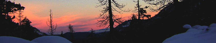
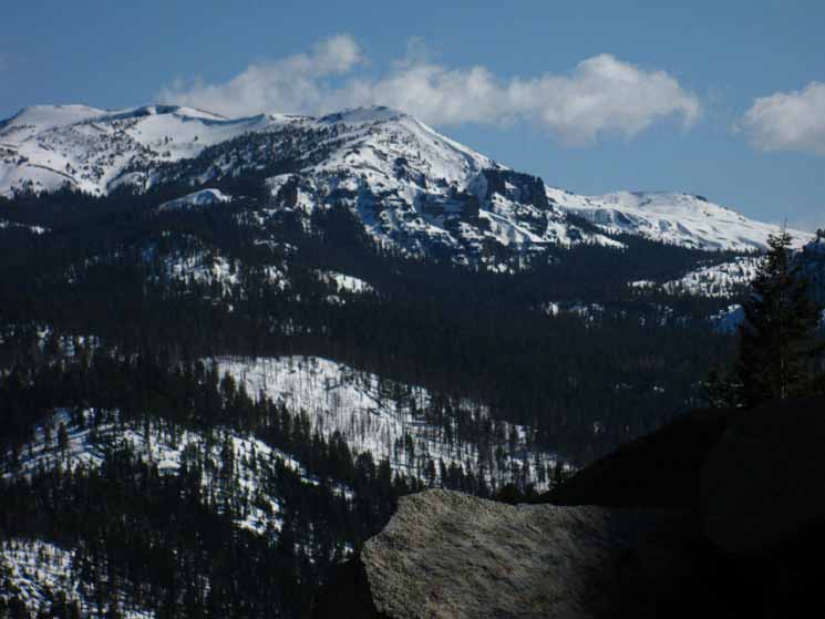
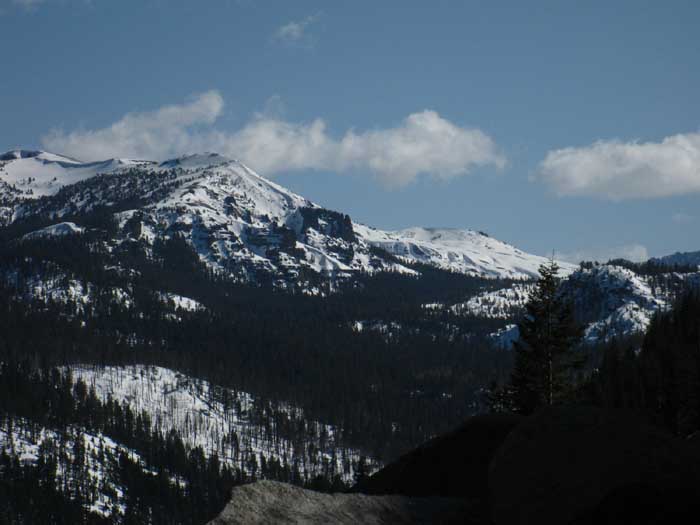
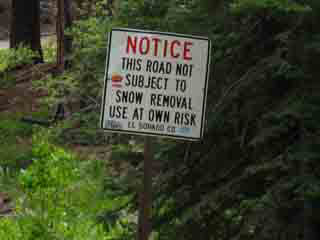
How to Get to the South Upper Truckee TrailheadFirst, The Grand Overview The South Upper Truckee Trailhead sits 857 feet almost directly below, but offset a just bit to the Southeast of the Echo Summit Trailhead. The South Upper Truckee Trailhead sits at the very Southern extent of Christmas Valley's flat-meadow area, served by the paved South Upper Truckee Road in the lakeside town of Meyers. Beyond the trailhead a stiff climb brings us about four miles South to Round Lake. Neither the Google or USGS Maps above do justice to the terrain. It is breathtaking. The view below looks South down into Christmas Valley from Highway 50 just a bit East of Echo Summit, 857 feet above, and just a bit Northwest of the South Upper Truckee Trailhead. Pulling off Highway 50 to take a quick look South into the upper reaches of Christmas Valley from Echo Summit we can look at the terrain our route crosses from the South Upper Truckee trailhead Southward. From here we can even make out the top of Round Top in the far distance, our destination when hiking the Tahoe to Yosemite Trail route South out of the Lake Tahoe Basin. In the picture below our trailhead for the South Upper Truckee trail sits out of sight below us and to our Right, our view of it cut off by the sheerness of the overhanging rock at our feet. The dense forest pictured in the middle of the image, sitting nestled in below the Right (West) flank of the great mountain rising on the middle-Left of the image, is Big Meadow. The mountain rising to the Left (East) of Big Meadow is the Waterhouse Massif. Waterhouse Peak is the furthest peak topping that mass of mountains rising on the Left side, the East side of the image. Our route following the Eastern Tributary of the South Upper Truckee River up to Round Lake is in a small narrow valley just out of our view to the Right (West) of Big Meadow. We follow this hidden valley South towards the Right side of the most-distant snow covered peak in the center-right of the image. That's Red Lake Peak rising above the Southeastern edge of Meiss Meadow, it's crest representing the Southernmost point of the South Lake Tahoe Basin's drainage. Out of sight to the Left (Northeast) is Stevens Peak, which is almost the Southernmost point of the Tahoe drainage. In the furthest distant Right we can see the dark mass of our destination and turnaround point of this particular snow trip we are doing, Round Top. Round Top is outside of the Tahoe Basin, located a couple of miles to the Southwest of Carson Pass. Round Top is the dark rounded mass in the far-Right distance, mostly hidden behind the snowy ridgetop in the middle-far-Right of the image below. It is located at middle height on the far Right side of the image. The Carson Gap is at the low point of the ridgeline descending to the Right (West) off of Red Lake Peak, the most distant snow covered peak in the distant middle-Left of the image. We will exit the Lake Tahoe Basin through the Carson Gap, located at the low point of the ridge descending off the Right (West) side of Red Lake Peak. This picture below of the South Upper Truckee River drainage in the Southern end of the Lake Tahoe Basin was taken in March of 2010 on the way to begin a snow trip out of the South Upper Truckee Trailhead to Round Top and back. Note: The videos are temporarily "broken" on the Tahoe to Whitney Backpacker's Forum. Sorry. Here's the video play list to compliment the text: Spring Snow March 2010, Meiss Country Spring Snow June 2010, Meiss Country
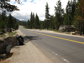
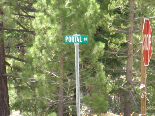
Other Views of Christmas Valley View our position here on Highway 50 at Echo Summit looking up from NOTE The South Upper Truckee Trailhead sits roughly between our position here on Highways 50 at Echo Summit and Highway 89 running under the forests below. Check out the topo and road maps of the South Upper Truckee Trailhead for the exact location of the South Upper Truckee Trailhead. Though Highway 89 climbs past Big Meadow to twist its route around the Left side of Waterhouse Peak, we cannot see it in the image above, being hidden under the dense forests. But it's there. If we are coming from either East or Westbound on Highway 50 to the South Upper Truckee trailhead, proceed on Highway 50 to the Meyers Junction of Highway 50 and 89 Southbound , and turn Southbound onto Highway 89 towards Luther Pass. Follow Highway 89 South through rural Meyers for 2.50 miles to Portal Drive , a Right turn on the West Side of Highway 89. Zoom the Google map above in a bit, and Portal Road connecting Highway 89 to the South Upper Truckee will appear. Turn West onto Portal Road off Highway 89. Follow Portal Road West to the South Upper Truckee Road. Turn Left (South) on South Upper Truckee Road and proceed to the end of the maintained road. At the end of the maintained road we find the South Upper Truckee Trailhead and a nice little parking area. An unmaintained length of the South Upper Truckee Road continues through the end of the maintained road up the steep climb connecting it to Highway 89 just a bit North of the location of the Big Meadow Trailhead on Highway 89. |
Visual
&
Road Directions
Highway 89 South to the Portal Road turnoff
2.5 miles South of the Highway 50 junction
Images
looking South down Highway 89 towards Luther Pass
We can see where the Highway begins Climbing towards Big Meadow in the far distance
Looking South across Highway 89 at the Portal Drive turnoff. |
Portal Drive on Highway 89. |
|||||
 |
 |
|||||
Highway 89 2.50 miles South on Hwy 89 from the junction of Highways 50 and 89 in Meyers. This picture is looking South across and down Hwy 89 at the Portal Drive turnoff. See my pack there? I'm hitching out after a five day snow trip, early 2009. |
The Portal Drive turnoff from Highway 89. |
Related Page: Lake Tahoe Trailheads South on the Trail: Meiss Country towards Round Lake
Portal Drive
|
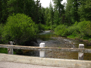
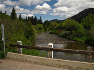
South Upper Truckee River
The Bridge Looking South |
The Bridge Looking North |
|||||
 |
 |
|||||
| Bridge over South Upper Truckee River, looking South up the Mountain. | Bridge over South Upper Truckee River, looking North towards Lake Tahoe. |
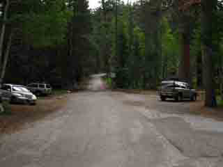
End of the Maintained Road
|
Approaching the South Upper Truckee Trailhead. |
The End of the Plowed Road. |
|||||
 |
 |
|||||
Looking East while walking South into the South Upper Truckee Trailhead parking, after crossing the bridge Southbound on the South Upper Truckee Road. The trailhead is on the Right. |
At the far end of the trailhead the Winter maintained road ends: Stop! Park! Hike! |
The South Upper Truckee Trailhead
in
Christmas Valley
via
Meyers
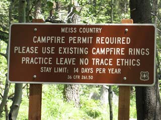
Trail Sign at South Upper Truckee Trailhead |
Information Board at the Trailhead |
|||||
 |
 |
|||||
New South Upper Truckee Trailhead Sign. No backpacking permits required, but fire permits required, and fire restrictions may be in effect. Especially during the brutal drought year of 2014. |
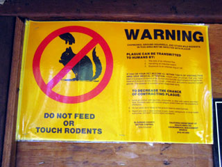
Long Story Short: Don't play with the baby squirrels or chipmunks. |
Trailhead Information
South Upper Truckee trailhead
|
The Long View South
Long Distance Backpacker mileagesSouth on the Pacific Crest Trail South Upper Truckee to: Carson Pass Ebbetts Pass Sonora Pass Tuolumne Meadows South on the Tahoe to Yosemite Trail South Upper Truckee to: Carson Gap Lake Alpine Saint Marys Pass Tuolumne Meadows The Tahoe to Yosemite and Pacific Crest Trails split at Carson Gap. |
 |
For more information see the Meyers Trailhead page on the forum. From there you can leave Comments & Questions, or Register and post up information. Know this place well? Registering allows you to share your experience and knowledge, even to put up your own pages about your tips and trips here on the Meyers to Carson Gap Forum. Pictures can be easily uploaded, videos and maps easily embedded. You can contribute words, pictures, and videos to each part of this trail through the forum attached to each trail guide page. |
A New Trailhead
to
compliment
the
New Trail Route to Round Lake
The South Upper Truckee Trailhead
|
Trailhead Culture
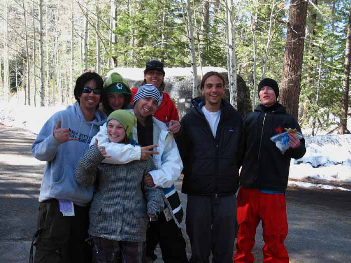
Local Color South Upper Truckee locals out for a Winter Day Hike. These were a great bunch of kids. Enjoyed their company immensely. |
||
 |
||
That's my buddy Steve Scheppers, who does music for the Tahoe to Whitney backpacking videos, the second from the Right. Steve is a great musician, you should hire him to entertain your party or wedding or soundtrack your videos or something... |
Last Moments before Heading out for Mount Whitney |
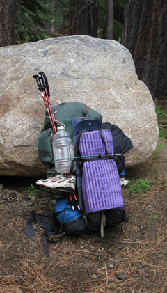
The Spring Pack at South Upper Truckee |
|||||
 |
 |
|||||
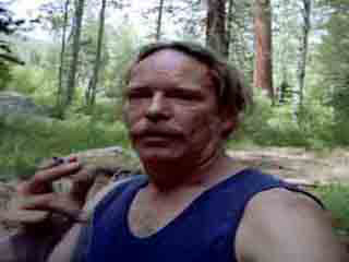
| First Smoke before... | ||||||
...saddling up the Harness of Pain and Pleasure... HOPP |
Related Page: Lake Tahoe Trailheads South: Meiss Country towards Round Lake
South Upper Truckee Road |
We're Here! The South Upper Truckee Road, which we are accessing from Portal Drive off of Highway 89, actually begins at Highway 50 by the KOA camp. This is the very long way to get to the trailhead, as it is a 25 mile per hour road from its beginning at Highway 50 all the way to the South Upper Truckee Trailhead. It is much quicker to take Highway 50 to 89 Southbound in Meyers, and follow Highway 89 to the Portal Drive turn, and from there access the South Upper Truckee Road. 7.5 Hiking Topo Map 30 min Hiking Topo Map |
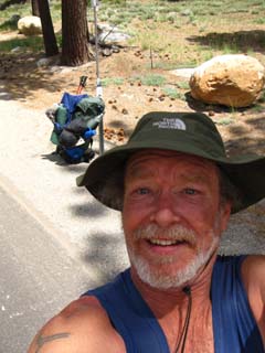
| June '09 trip to Round Top Lake and back finished, hitching to S. Lake Tahoe for Food, then off to Walker and the E. Fork of the Carson. for some more Spring Snow backpacking |
||
 |
||
| On the Road Again, after the apartment burned down. But I spent much more time on the trail than on the road. |
Backpacking Trail Guide North |
 |
Backpacking Trail Guide South |
Backpacker ForumsGeneral Sierra Nevada hiking thoughts, trails, or backpacking topics to relate? Post 'em on
On the Forum you can browse trail locations and add your experiences, comments, questions (& pictures and videos if you Register...) about hiking South out of the South Upper Truckee trailhead. General comments about the South Upper Truckee to Carson Gap section of the High Sierra trails, or this particular location: Section
|
Related Page: Lake Tahoe Trailheads South: Meiss Country towards Round Lake
Trailhead
Contact
Alex Wierbinski

Backpacking Lake Tahoe to Mount Whitney
Your guide to the High Sierra Crest, including the Tahoe to Yosemite, Pacific Crest, and John Muir Trails
