

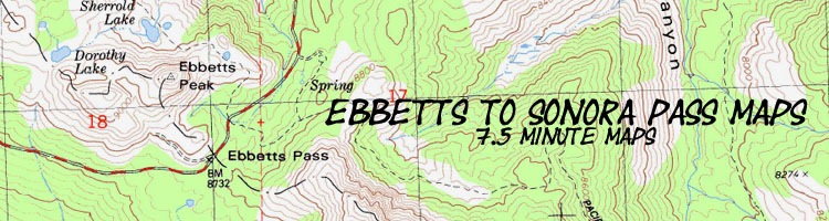
Backpacking topo Map
Swampy Lake
to
Boulder Lake Trail
Carson Iceberg Wilderness
Hiking maps for The Pacific Crest Trail between Ebbetts Pass and Sonora Pass
| North Topo Hiking map Wolf Creek to Swampy Lake |
South Topo Hiking map Boulder Lake to Sonora Pass |
Ebbetts |
Ebbetts Pass to Sonora Pass Miles and Elevations |
BIG TOPO BACKPACKING MAP Ebbetts Pass to Sonora Pass |
Click RED DOTS for links to Trail Guide Page |
Trail Guide |
all maps |
all pages |
all Miles and Elevations |
map info |
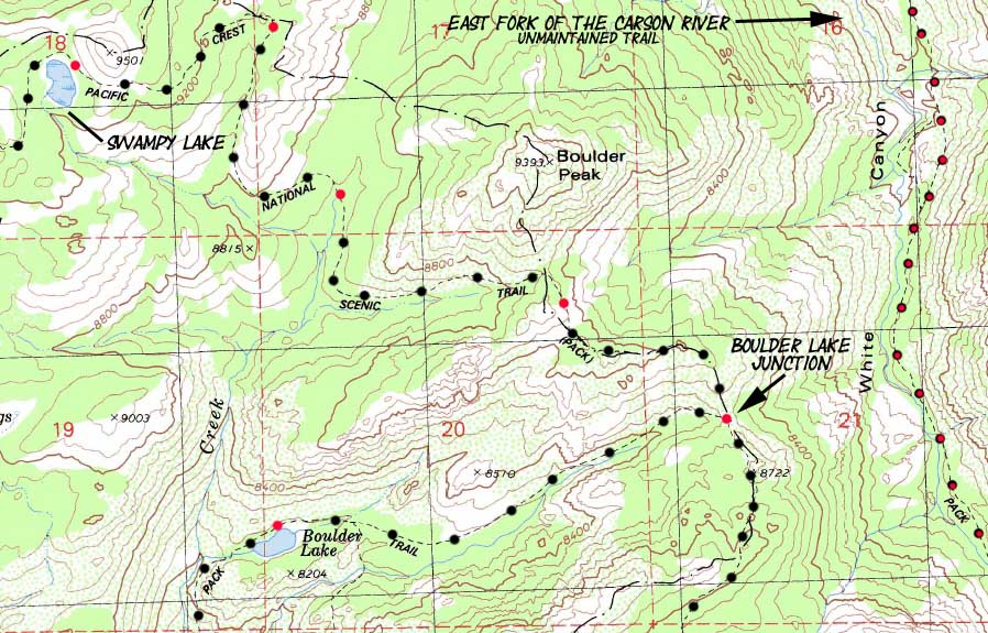
Topo Hiking Map 3.06 miles from Swampy Lake South of Golden Canyon to the Boulder Lake trail junction.
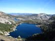
Region Map
Asa Lake to East Fork of the Carson River
| North Wolf Creek to Swampy Lake |
Click red dots | South Boulder Lake to Sonora Pass |
|
Region Map
Asa Lake to East Fork of the Carson River
| North Wolf Creek to Swampy Lake |
Click red dots | South Boulder Lake to Sonora Pass |
Mapology |
||||
MAP NOTE What's important for our general reference purpose is that each side of a square is 1000 meters, or a Kilometer. From my point of view that is 1093.6 yards or .62 of a mile. Diagonal: 1414.22 meters, if my trig is correct. That converts the diagonal distance into 4,639.8 feet or .88 of a mile.
|
| Hiking the Carson Iceberg Wilderness from Swampy Lake around Boulder Peak to Boulder Lake Trail Junction |
Main Features: The roller coaster picks up speed from the Swampy Lake South to the Boulder Lake Trail Junction. Winding Northeast from the Swampy Lake around the South side of Peak 9501 gives up some nice views of the East Carson River before we turn Southwest to begin winding our way around the Southwest side of Boulder Peak. On the West side of Boulder Creek we cross Boulder Creek high up its drainage, at the top of its year-round flow. Just South of Boulder Creek there are nice campsites on both sides of the Pacific Crest Trail. Climbing Southeast around the South side of Boulder Peak brings us through a channel of forest and rock to a fine overlook of the East Carson River in its granite gorge. Continuing South we continue to climb the last ridge arm separating us from the Boulder Lake Trail Junction. The trail from the Tahoe to Yosemite trail along Clarks Fork of the Stanislaus River through Boulder Creek is the shortest connector of the 4 that tie these two trails together as they cross the Carson Iceberg Wilderness. Below us to the East the East Fork of the Carson River sits at the bottom of its great granite-faced gorge. The unmaintained trail route along the East Carson River will join with the Pacific Crest Trail in a few miles. We will take a break at this junction after we hike down the switchbacks off the crestline to river level. This sloppy article describes entering the East Carson River and its unmaintained trail from the East. This map depicts the Pacific Crest Trail from the Swampy Lake around Boulder Peak and Creek to the Boulder Lake Trail Junction. |
Map Miles, Elevations Information |
|
Miles and Elevations Marsh Lake 9200 14.65 Al Camp at Boulder Creek 8640 16.71 East Carson River Overlook ---- 17.1 Boulder Lake Junction 8560 17.71
Ebbetts to Sonora Pass Topo maps Index
Nearby trailheads, North to South Ebbetts Pass Trailhead Gardner Meadow Trailhead Disaster Creek & Clarks Fork Trailheads Sonora Pass Trailheads |
USGS Topo Map Information Map Name
Compass Offset scale: 1:24 000 Contours: 80 Feet Permits National Forest Contacts Backpacking permitting authority Wilderness Area |
Topo Hiking Map North: Wolf Creek to Swampy Lake Topo Hiking Map South: Boulder Lake to Sonora Pass
| Elevations | More Information | ||
Swampy Lake: 9200 feet Boulder Creek Campsites: 8640 feet Boulder Lake trail junction: 8560 feet |
Trail Guide, Section: Ebbetts Pass to Sonora Pass Trail Guide, Segment: Ebbetts Pass Trail head Google Map: Highway 4 |
||
Map Credit |
U.S. Geological Survey, Department of the Interior: The USGS Use search term "Meeks Bay," and "Address," as search type to locate this USGS map. USGS Topographic |
Ebbetts Pass
Trailhead
Gardner Meadow
Trailhead
Disaster Creek & Clarks Fork
Trailheads
Sonora Pass
Trailhead