The Trails
Guide
Maps
Miles/Ele
Permits
Resupply
Forum
Current Weather Conditions
Weather Notes
Northern High Sierras
Central High Sierras
Southern High Sierras
Gear
Gear List
Gettin Started
Layering
Discussion
Testing yourself and your gear
Gear Reviews
High Sierra Nevada History
and
Historical Monuments
Languages
Languages
Trail Arts
The art of walking
Physical Preperation
Trail Skills
The trail
Off the trail
Scrambling
Maps
Navigation
Camp skills
Food
Resupply
Food
Other
Photo Catagories
Trail Stories
Trail Culture
News and Science
Links
Groups
Books
Terms and Conditions of Use
| Traill Guide Tahoe to Whitney | Backpacker Forum | Maps | Miles and Elevations | Permits | Resupply | gear | weather | camp skills | living things |
High Sierra History
for the
Backpacker and Hiker
|
|
Sierra History General Introduction to Note that the recent names of topographic features represent the character of our interaction with the terrain. We can make out a trajectory of naming trends over our time in the Sierra. For example, Silver Creek, Silver Peak, and the Silver Trailhead in the Carson-Iceberg Wilderness all harken back to the great Silver Boom of the late 1850s that followed on the coattails of the Gold Rush. The Western foothill communities along Highway "49" make a living off of their Gold Rush history, and revel in their Gold Rush history. I think of "Hangtown," otherwise known as Placerville... These mountains were overrun first by gold prospectors during the early 1850s, and then by seekers of silver in the late 1850s through the 1860s. Prior to the frenzy of the Gold Rush and Silver Boom early explorers and settlers probed the Sierra for a path to the Pacific to access its other previously known natural resources. Many met hard ends in the attempt. The best concise history of early Western exploration I've found is the introduction to the History of the Toiyabe National Forest, (pdf). The first six or seven pages are a good read covering early American exploration. As we head South from Lake Tahoe towards Yosemite we will encounter Disaster Peak, Relief Peak, along with a series of terrain features that broke many wagons while testing the fortitude of early hikers and riders. The Sierra was the forum for demonstrating the apparent lack of common-sense of many of the people who attempted to cross with a wagon before the main roads were established. The Clamper's Historical monument at Sonora Pass attests to these attempts. As do such well know ill-fated attempts as the Donner Party.(1879 ed.) If you have hiked or driven the lengths of Highways 88, 4, and 108 across the Sierra crest and its approaches, you know what I mean. Those are a some of mean hikes into the Sierra up into the sheer Eastern Escarpment of the Sierra, and are still mean routes even with our modern roads! I have crossed significant sections of the Sierra without aid of trail or road, so I can see early Western explorers crossing the Sierra without road or trail by hiking, or with a well-equipped and well-provisioned horse and mule team. But not with a wagon. I can say one thing about the early attempts to cross the Sierra with a wagon: they did not scout the route beforehand, or they would not have attempted it with wagons. A little scouting would show even a well-provisioned mule team would have a hard time getting through, and I'd be looking for all the Indian and animal trails I could possible find along the way. History in the Sierra continued after the tidal waves of the first explorers and settlers seeking gold and silver passed. Later in time we find remnants of Civil War loyalties in Jeff Davis Peak and Border Ruffian Flat along the NE side of the Molkeulmne Wilderness. And even later, and further South, we encounter the history of the naturalists and wilderness explorers of the late 19th century who left their names and interpretations on the terrain. I'm thinking of Muir Pass and Evolution Basin. These later explorers brought legal protection with them to the mountains, and we can still see the first marks left by the men who first patrolled these mountains. In North Yosemite we still sometimes follow the "T" for Trail blazes that the US Calvary carved into trees to mark their patrol routes through the Northern Yosemite Backcountry. In the Southern Sierra we trace the footsteps of John Muir between Yosemite and Mount Whitney. I'm always looking out for people with historical knowledge about the Sierra to contribute and share their knowledge with us backpackers. I have a collection of images of historical locations that this page will document. When I finally finish building the website I will have the time to stock it up with more detailed Sierra histories to compliment the age and dignity of the range. In the meantime I hope this page stimulates you to search out the history of the areas you are hiking through. The more you know the more you see in every glance, bringing us deeper into the range. |
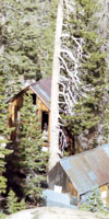
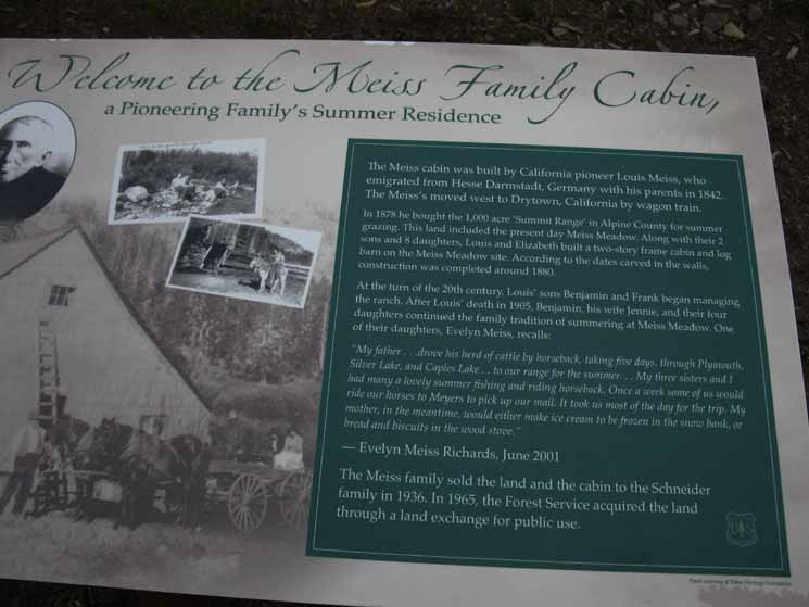
Meiss Cabin Historical Monument
 |
| Guide Meiss Meadow Map Meiss Country Roadless Area |
 |
Text |
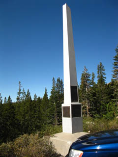
Carson Pass
| Snowshoe Thompson Monument | Kit Carson Tree Carving Monument text. | |||
 |
 |
|||
Carson Pass Monument See the Carson Pass trail guide for information about Carson Pass along the routes of the Pacific Crest and Tahoe to Yosemite Trails.
|
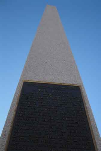
Plaque on Kit Carson Monument, Native Sons of the Golden West. This monument is located to the East of the obelisk. Text below. For more information about Carson and Fremont, along with their contemporary and earlier American High Sierra Explorers, see |
Thompson Obelist
and
Carson Tree Monuments at Carson Pass
 |
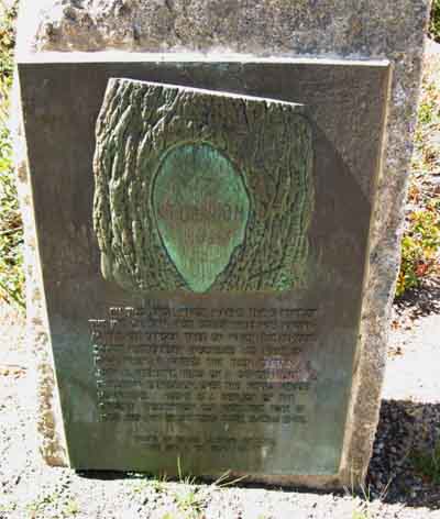 |
Snowshoe Thompson monument at Carson Pass. SNOWSHOE THOM(P)SON A TRUE PIONEER "...There ought to be a shaft raised to Snow-Shoe Thompson not of marble; not carved and not planted in the valley, but a rough shaft of basalt or of granite, massive and tall, with top ending roughly, as if broken short, to represent a life which was strong and true to the last, and this should be upreared on the summit of the mountains over which the strong man wandered so many years, as an emblem of that life which was worn out apparently without an object." |
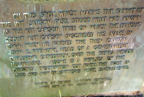
Kit Carson carved tree monument at Carson Pass.
On this spot, which marks the summit of Kit Carson Pass, stood what was known as the Kit Carson Tree on which the famous scout Kit Carson inscribed his name in 1844 when he guided the then captain John C. Freemont, head of a government exploring expediton over the Sierra Nevada Mountains. Above is a replica of the original inscription cut from the tree in 1888 and now in Sutters Fort, Sacramento.
|
Carson Pass InformationLocation Elevation National Forest ENFIA Trail Guide Information
Trail Culture |
Carson Pass Road Map
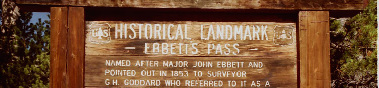
Ebbetts Pass
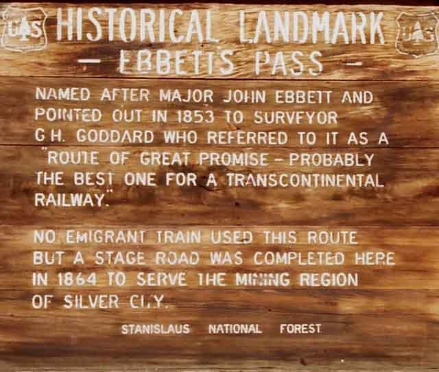 |
Ebbetts Pass InformationLocation Elevation National Forest
Trail Culture |
Ebbetts Pass Road Map
From the East: The Golden Gate Mine
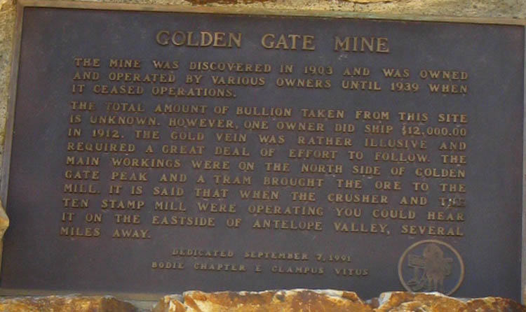
Golden Gate InformationLocation Elevation: Trail Guide Page
Backpacker's Forum Backpackpacker's History Forum Topic
USGS Backpacking Topo Maps But this map does locate parts of the route: Ebbetts Pass to PCT junction with the East Carson River. (This is where I join the PCT when entering the Sierras from the East at Little Antelope Pack Station.) |
Golden Gate Mine on a Road Map
Sonora Pass
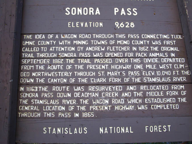
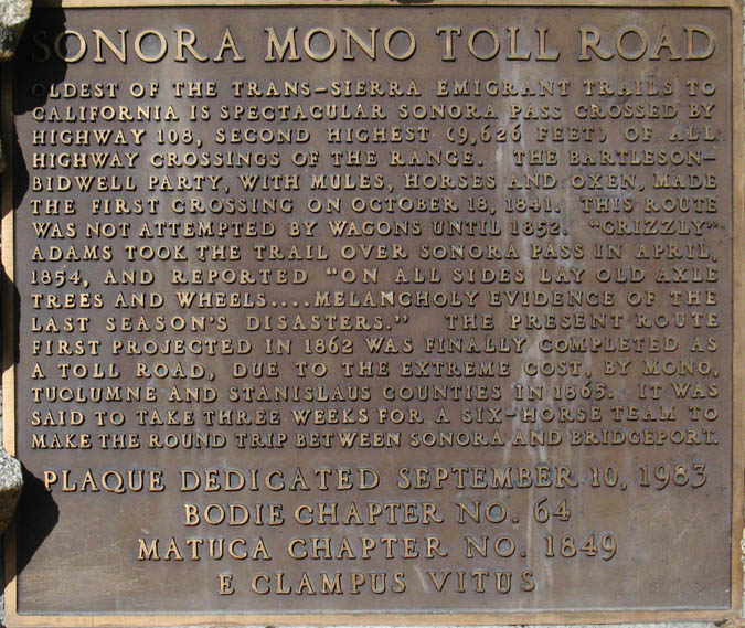
Sonora Pass InformationLocation Elevation Sonora Pass-Mono Road, Clarks Fork Roads History
Trail Culture |
Sonora Pass Road Map
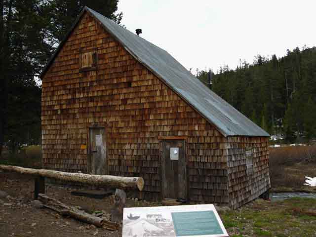
Kennedy Meadows Pack Station Historical Monuments
Clampers, Emigrants of 1852-53
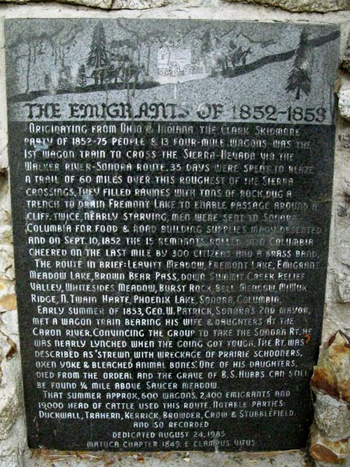
(TEXT) THE EMIGRANTS OF 1852-1853 Originating from Ohio & Indiana the Clark Skidmore Party of 1852, 75 people & 13 four-mule wagons-was the 1st wagon trail to cross the Sierra-Nevada via the Walker River-Sonora Route, 35 days were spent to blaze a trail of 60 miles over this roughest of the Sierra Crossings. They filled ravines with tons of rock, dug a trench to drain Fremont Lake to enable passage around a cliff. Twice, nearly starving, men were sent to Sonora-Columbia for food and road building supplies. Many deserted and on Sept 10, 1852 the 15 remnants rolled into Columbia cheered on the last miles by 300 citizens and a brass band. The route in brief: Leavitt Meadow, Freemont Lake, Emigrant Meadow Lake, Brown Bear Pass, down Summit Creek, Relief Valley, Whitesides Meadow, Burst Rock, Bell Meadow, Miwuk Ridge, N. Twain Harte, Phoenix Lake, Sonora, Columbia. Early Summer of 1853, Geo. W. Patrick, Sonora's 2nd Mayor, met a wagon train bearing his wife & daughters at the Carson River. Convincing the group to take the Sonora Rt. He was nearly lynched when the going got tough. The Rt. was described as "strewn with wreckage of prairie schooners, oxen yoke & bleached animal bones. One of his daughters died from the ordeal and the grave of B.S Hubbs can still be found 1/4 mile above Saucer Meadow. That Summer Approx. 600 wagons, 2400 emigrants and 19,000 head of cattle used this route. Notable parties: Duckwall, Trahern, Kerrick, Browder, Crow & Stubblefield. And so recorded |
Kennedy Meadows Pack Station InformationKennedy Meadows Pack Station Location As a As a point along the Kennedy Meadows Backpacking Map
|
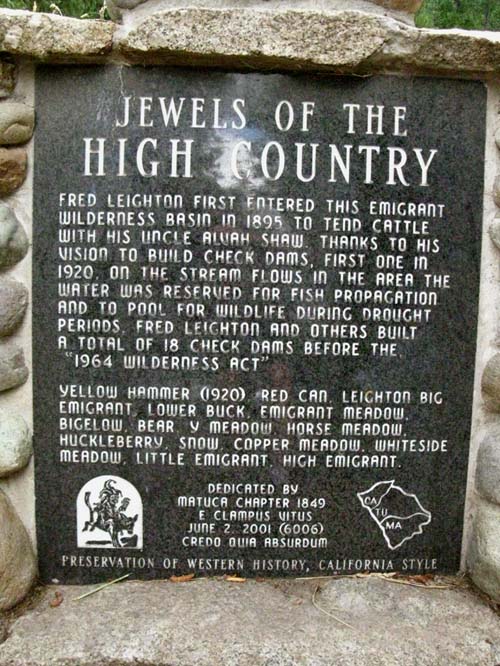
Clampers, Herder-Grazer Check Dams
Forum |
Last page: Trail Culture Next page: Backpacking Arts and Letters
High Sierra Historical Monuments |
Backpacker's Forum Topic Sierra Nevada History-Historical Monuments
New THESE PAGES ARE UNDER CONSTRUCTION: STAY TUNED FOR MUCH MORE! COME ON BACK NOW, 'YA HEAR?
|
Backpacker Forums Have a great Sierra Nevada route or trip to relate?Post it on Experiences, comments, questions, or pictures about High Sierra History?
|
Trailhead
Contact
Alex Wierbinski

Backpacking Lake Tahoe to Mount Whitney: Your guide to the High Sierra Crest, including the Tahoe to Yosemite, Pacific Crest, and John Muir Trails
