The Trails
Guide
Maps
Miles/Ele
Permits
Resupply
Forum
Current Weather Conditions
Weather Notes
Northern High Sierras
Central High Sierras
Southern High Sierras
Gear
Gear List
Gettin Started
Layering
Discussion
Testing yourself and your gear
Gear Reviews
Hiking South
Covering
Maps, Miles, Elevations,
|
|||||
below |
|||||
|
|
||||
|
Trail Section I Meeks Bay
Backpacking
TYT and PCT
Trail Guide
Echo Summit Trailhead Information
South Upper Truckee Trailhead Information
Trail Meeks Bay to Echo Summit PCT-TYT
Echo Summit to Carson Pass PCT-TYT
Trail Maps Desolation Wilderness Meiss Country Roadless Area
Lake Tahoe Trailheads Click the Red Dots on the small-scale maps,
Map Lists Desolation Wilderness
Echo Summit to Carson Pass
Permits Lake Tahoe Basin Management Unit
Backpacker Resupply Echo Lake Chalet Backpacker Resupply
South Lake Tahoe Backpacker Resources
Videos
Backpacker's Forums
Meiss Country Roadless Area
The Lake Tahoe Basin South of Desolation Wilderness our route crosses Echo Summit on Highway 50 entering Meiss Country Roadless Area. Echo
Summit is an alternative Southbound trailhead below Desolation Wilderness and shortening our Southbound hike to Tuolumne Meadows by about 30 miles. We cross the Meiss Country to climb to our exit from the Southwestern corner of the Tahoe Basin through the gap above Carson Pass I call the Carson Gap. At the central trail junction of the Meiss Roadless Area at the Meiss Cabin the Tahoe Rim Trail turns Northeast where our combined PCT-TYT routes continue South across the Southern end of Meiss Meadow, putting ourselves under the Carson Gap for the climb out of the Southernmost end of the Tahoe Basin. We'll get some great views South of the upcoming TYT route over Round Top and The Sisters, as well as a look at the PCT's path around Elephant Back as we hike through the Carson Gap exiting the Lake Tahoe Basin. Permits Though the Meiss Area requires no permits, through hikers into other areas will want to draw a permit from the LTBMU to authorize backpacking through the subsequent forests and wilderness areas we will cross after departing the Meiss Country. No problem. As the Meiss Area requires Fire Permits we'll pick up our hiking and fire permits at the same time. |
|
Highway 88
Backpacking
PCT or TYT PCT TYT
Trail Guide
3 Routes to the TYT from the Carson Gap
Round Top Lake
Trail Carson Pass to Ebbetts Pass PCT
Trail Maps Mokelumne Wilderness
Click the Red Dots on the small-scale maps,
Map Lists West Mokelumne Wilderness
East Mokelumne Wilderness
Permits
West Flank
Backpacker Resupply
Videos Carson Pass to Ebbetts Pass PCT
Backpacker's Forums
West Mokelumne Wilderness
Full TYT-PCT
The Mokelumne Wilderness These are the Tahoe to Yosemite Trail down the Western flank of the Sierra to Lake Alpine or the Pacific Crest Trail along the Sierra Crest and Eastern flank to Ebbetts Pass. Lake Alpine is located about 15 miles down the Western flank of the Sierra on Highway 4 from Ebbetts Pass. Differences between the TYT and PCT routes. Section 2 This section is very different from the PCT. It descends down the West flank to 5280 feet over a very difficult unmaintained route through a steep and deep granite gorge into a majestic West flank valley before climbing Mount Reba to access Lake Alpine. 9+ miles of this route are through complex terrain decorated with faint trails, at best. The Spring of 2017 looks like it may do some damage... Section 2a Standing at the Carson Gap puts us close to two nearby shortcut options breaking off the PCT to the TYT. Or, we can continue South along the PCT route to access the TYT by hiking South through Carson Pass along the PCT. All three of our trail options for turning Southwest onto the Tahoe to Yosemite Trail meet at the Round Lake trail junction below the peaks of Round Top and The Sisters. Each route to Round Top Lake & trail junction crosses a very different character of trail. Each explores a different aspect and different approaches. Permits The Tahoe to Yosemite Trail tracks across the El Dorado National Forest's remote Western Mokelumne Wilderness. Nonetheless, the Amador Ranger District of the El Dorado National Forest issues permits North and South out of the Carson Pass Trailheads. |
|
| See below for links to maps, miles, images, videos, and trail guide pages | ||||
Languages
Translate
Trail Arts
The art of walking
Physical Preperation
Trail Skills
The trail
Off the trail
Scrambling
Maps
Navigation
Camp skills
Food
Resupply
Food
Other
Photo Catagories
Trail Stories
Trail Culture
News and Science
Links
Groups
Books
Trail Guide Section 1 |
||||||||||||||||||||||||
Section One
|
||||||||||||||||||||||||
| Meeks Bay | Echo Summit | South Upper Truckee |
3 Lake Tahoe Basin Trailheads
on a
Road Map
Detailed Backpacking Maps
| Desolation Wilderness Backpacking Map |
Meiss Country Roadless Area Backpacking Map |
Introduction
Trailhead Options
There are many more than the three excellent trailhead options described below along the West and Southwest shores of the Lake Tahoe Basin from where we can begin our Southbound backpacking trips to Yosemite, or on down the length of the Sierra Crest Trails to Mount Whitney.
Our "Tahoe to Whitney" trip can be customized to begin from your favorite Tahoe Basin Trailhead. Refer to the maps above to find your own alternative Lake Tahoe Trailhead to begin your local or long distance backpacking trips. This guide contains information for backpacking through Desolation Wilderness and the Meiss Country Roadless Area.
Local Trip Options
We may decide to remain within Desolation Wilderness and/or Meiss Country in the Tahoe Basin for our first few High Sierra backpacking trips, if we are just getting started backpacking, or restarting after a long break.
Desolation and Meiss Country in the Tahoe Basin, and even Round Top in the Carson Pass Management Area just outside the Tahoe Basin near Carson Pass, are all excellent places for less experienced backpackers to develop fitness and skills by taking a few short preparatory backpacking trips before hiking from Tahoe to Yosemite, or all the way down to Mount Whitney.
More rookie backpackers attempting the PCT (there are many every year) would succeed if they started with a few shorter trips before jumping onto the long trails.
The Beauty and Utility of the Lake Tahoe Basin
The Tahoe Basin is a good place to work out our gear issues, finish off breaking in a set of boots, come to a gradual understanding with the nature of the workload, and get us used to life on the trail before we commit to a long backpacking trip.
This guide is tailored to provide information for experienced long distance backpackers to plan long distance backpacking trips along the Sierra Crestline. It is also designed to provide the layers of information necessary to help rookie short distance backpackers evolve as painlessly as possible into experienced long distance backpackers.
All Steps lead to the Sierra Crest
For some folks these are small steps transitioning comfortably into the rigors of long distance high altitude trails, for others it is a mighty leap requiring extensive preparation and training.
It is important for us to be aware of which scenario it is for us. It is even more important that we understand and respect our physical and psychological limits, and to stay within them as we evolve the necessary skills and fitness for long distance High Sierra backpacking.
Don't just jump off into the deep end of the pool.
Staying between the lines of our own limits will allow us to safely expand our limits until we are safely and comfortably capable of long distance High Sierra backpacking.
The Long Trails
If our backpacking trip covers any significant distance along the Sierra Crest our trail must hook up with the Tahoe to Yosemite and/or the Pacific Crest Trail routes described below. These are the backbones of the long trails South to Tuolumne Meadows, and these crestline trails will bring us across all the forests, parks, and wilderness areas that lay between Lake Tahoe and Mount Whitney.
The Classic Tahoe to Yosemite Trail route
This guide begins hiking South towards Mount Whitney out of the Classic Tahoe to Yosemite Trailhead at Meeks Bay. We intersect with the Southbound PCT and the Tahoe Rim Trail 11.5 miles Southwest of the Meeks Bay Trailhead on the North end of Desolation Wilderness just a bit North of Middle Velma Lake where we are hiking off the South flank of Phipps Peak.
The Tahoe Rim Trail Too..
From this trail junction in the North Desolation Wilderness these three trails run South together across the length of the Desolation Wilderness. We cross Highway 50 at Echo Summit where they begin bending with the Southeastern arc of the Tahoe Basin to Meiss Cabin.
The Tahoe Rim Trail breaks off Northeastward to remain within the Lake Tahoe Basin from the Meiss Cabin junction. Our still unified TYT and PCT routes continue Southeast together across the remaining bit of Meiss Country to exit the the Tahoe Basin through the Carson Gap.
Three Lake Tahoe Trailheads
The three Lake Tahoe trailheads described below open up a wide range of local hikes, in-and-out backpacking trips, and trailhead to trailhead hiking trips through the Desolation Wilderness and Meiss Country that never have to exit the Lake Tahoe Basin for endless backpacking joy.
Me? I say go big.
Let's walk it down to Whitney!
These are our first steps and miles on the long trails South.
top of page
| WEST Lake Tahoe Basin Trailhead #1 |
Classic
Tahoe to Yosemite
Trailhead
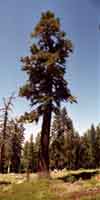
Meeks Bay Trailhead
Information
| Lake Tahoe Resupply Point #1 Note that Echo Chalet sits between the Desolation Wilderness to the North and the Meiss Roadless Area to the South. |
|||||
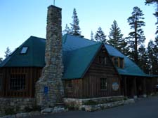
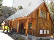
Echo Lake Chalet
Echo Lake Backpacker Resupply Though the short distance between Meeks Bay and Lake Alpine reduces Echo Chalet's utility for Southbound backpackers out of Meeks Bay, Echo Chalet is a vital resupply point for Northbound Pacific Crest Trail backpackers. Many PCTers choose to Rest and Resupply at South Lake Tahoe. Read this discussion of the resupply role of the Echo Lake Chalet for long distance backpackers. The Echo Summit and the South Upper Truckee trailheads are South of Echo Chalet, making Echo Chalet irrelevant for Southbound hikers out of those trailheads. |
|||||
| Lake Tahoe Basin Trailhead #2 |
Echo Summit
on
Highway 50
The Echo Summit Trailhead
North End
of the
Meiss Country Roadless Area
|
|
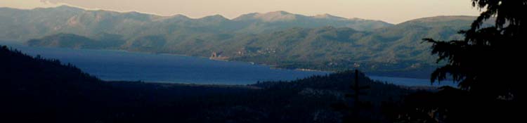
Lake Tahoe |
Meyers-Christmas Valley
The South Upper Truckee Trailhead
Meiss Country Roadless Area
|
|
Trail Guide Section 2
Highway 88
to
Highway 4
Question
Which Way South?
The Pacific Crest
or
The Tahoe to Yosemite Trail?
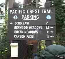
The Carson Gap is the gap on the South end of the Tahoe Rim where all Southbound Pacific Crest and Tahoe to Yosemite Trail backpackers exit the Lake Tahoe Basin. The Carson Gap is located 1.39 miles North of the Carson Pass and 10.61 miles South of the Echo Summit Trailhead along the PCT route, and 7.03 miles from the South Upper Truckee Trailhead.
The Carson Gap is our decision point.
TYT
to
Woods Lake
On the South side of the Carson Gap Southbound backpackers following the Tahoe to Yosemite Trail to Lake Alpine immediately encounter an unmarked trail junction veering right off the PCT route. This is the Northernmost of three junctions where the Tahoe to Yosemite Trail splits off to the Southwest from the Pacific Crest Trail.
The first two junctions below the Carson Gap are unmarked and join together at the creek to lead us down an unmaintained route to Highway 88. We cross Highway 88 to follow the dirt utility road towards Woods Lake.
Below we study the route differences on the maps and discuss them as well.
Carson Pass Area Backpacking Map Mokelumne Wilderness Backpacking Map Discussion
Differences between the TYT and PCT routes
Three Routes South
along the
Tahoe to Yosemite Trail
On the South side of the Carson Gap where the PCT levels out there is another, second unmarked trail junction leading Right towards Highway 88 and up to the TYT at Round Top Lake via Woods Lake. Both of these first two trails merge together above Highway 88, cross it, and follow the dirt utility road towards Woods Lake.
Our third, final, and Southernmost option for turning off the PCT onto the Tahoe to Yosemite Trail is the Winnemucca Lake Junction, which sits a mile South of Carson Pass along the Pacific Crest Trail.
From Woods Lake we have two routes up to the TYT at Round Top Lake. The "center" route brings us past Winnemucca Lake on our way up to Round Top Lake while the Lost Cabin Mine trail brings us the most Westernmost route up to the TYT at Round Top Lake.
This image is marked with
The two routes to Round Top Lake from Woods Lake.
See this short video that takes a look at the routes of these three routes to the Tahoe to Yosemite Trail on the South side of the Carson Gap.
One Route South
along the
Pacific Crest Trail
Hikers on the Pacific Crest Trail will ignore these 3 junctions bracketing Carson Pass while hiking the PCT South to and through Carson Pass on our way to Ebbetts Pass.
The Carson Pass topo hiking map below shows us 2 of these 3 trail junctions, while the map of the Mokelumne Wilderness gives us a broader context of the differences between the PCT and TYT routes on their respective Eastern and Western flank routes down to Highway 4.
Compare the Classic routes of the Tahoe to Yosemite and Pacific Crest Trails across the Carson Pass Management Area and the Mokelumne Wilderness to determine which route best suites your skill and fitness levels.
The TYT route has unmaintained segments that can present physical and navigation challenges.
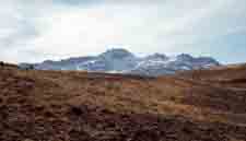
Looking South through the Carson Gap
out of
The Lake Tahoe Basin
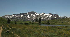 View South of Round Top and The Sisters through Carson Gap |
 |
 |
|
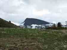
| View of Round Top and The Sisters through Carson Gap later in Spring Time with the Carson Gap Pond in the foreground. | Above: looking Southeast at Elephant Back through the Carson Gap. The Winnemucca Lake junction on the PCT to the TYT at Round Top Lake sits below Elephant Back on the Pacific Crest Trail. |
||
|
|||
Click on the Black Dotted trail routes for detailed trail maps, click RED DOTS for location information.
PCT-TYT
Options
hiking
South
from
Highway 88
of the
The Mokelumne Wilderness
Section II
East Flank
Pacific Crest Trail
PCT
Carson Pass
to
Ebbetts Pass
Eastern
Mokelumne Wilderness
PCT
Carson Pass to Forestdale Divide
Forestdale Divide to Blue Lakes Road
Along the Mokelumne Wilderness Boundary
Raymond Lake Junction to Ebbetts Pass
PCT
Carson Pass Region Backpacking Map
Mokelumne Wilderness Topo Hiking Map
Map Index
Miles and Elevations
Videos
Permits
Trail Forums
One Route South We'll first enter the Northern Trailhead and parking lot, which sports toilets and garbage cans, 'though no water. Water is in short supply at the Carson Pass Trailheads and at the Carson Pass Cabin. The
The Carson Pass Cabin Hike Both Routes! The PCT vs. The TYT Both routes are worthy of our attention.
The PCT
The
TYT The TYT is an unmaintained route from Horse Canyon to Camp Irene. difficult segments of the route can be found beyond or before Camp Irene, depending on the damages of the Spring Thaw and the fertility of tree and plant growth. The TYT route is rougher, hiking through much more isolated terrain. Its difficult navigation and extra physical requirements demanded by the unmaintained section of the trail between Summit City Creek and Camp Irene make it a much more difficult route than the PCT from Carson to Ebbetts Pass.
NOTE The Tahoe to Yosemite Trails Forum has a section of backpacker submitted trail conditions updates for the past few hiking seasons along the the unmaintained segment of the Tahoe to Yosemite Trail through both Summit City Creek and the untrailed segment through Saint Marys Pass. Refer to it for current information, update to it after you hike through. |
Section IIa
West Flank
Tahoe to Yosemite Trail
TYT
Carson Gap
to
Lake Alpine
Western
Mokelumne Wilderness
TYT
TYT
Carson Pass Region Backpacking Map
Mokelumne Wilderness Topo Hiking Map
Map Index
Miles and Elevations
Videos
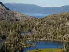
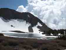
3 TYT Routes to Round Top Lake from the Carson Gap
Permits
Trail Forums
3 Routes South TYT Shortcuts The Center Route turns East (Left) across a footbridge just North of Woods Lake. This trail tracks South to pass by Winnemucca Lake, where it turns West for the short climb up to Round Top Lake. This would be the Center Route. The Western Route is the Lost Cabin Mine trail, which begins behind the Woods Lake car campground off to our West, our Right. This route is more direct but steeper, and approaches Round Top Lake from the North. This Western Route is the most direct route to the top of Round Top and the Sisters. If we passed the first two unmarked trail TYT junctions below the Carson Gap hiking to Carson Pass we can still follow the 3rd and final Tahoe to Yosemite Trail junction from the Winnemucca Lake Junction. All three of these routes intersect at the point pictured below, at the Round Top Lake trail junction. Our Southbound TYT proceeds South around the Western Shoulder of the Sisters from the Round Top Lake trail junction, the Right side of the image below, to find our descent into the unmaintained TYT route through Summit City Canyon. Passing around the Right side of the Lake and mountain flank in the image above we bend Southwest around the descending crest. The |
Next
Resupply Point
South
Lake Alpine
on
Highway 4
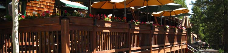
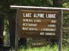
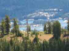
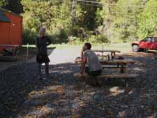
The Lake Alpine Lodge
Deck dining at The Lake Alpine Lodge
|
Lake Alpine Lodge
Lake Alpine Lodge
A stunningly-beautiful man-made lake on Highway 4 sporting a rustic lodge with really friendly folks on its Southwest shore. Lake Alpine Lodge offers a free resupply service for long distance backpackers, a Bar, an expensive very high quality restaurant, a reasonable bar menu, a car-camper store, showers, laundry, and the nicest local folks working here. The only stipulation for Lake Alpine managing your resupply is that the package must be sent via UPS.
See the Lake Alpine Backpacker Resupply page for the specifics and contact information.
|
|
Kicking Back Time at Lake Alpine Lodge
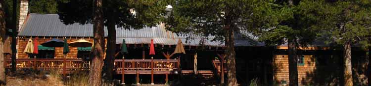
Lake Alpine Lodge overlooking West shore of Lake Alpine, deck seating for eating.
Resupply Information
and
Road Directions
Lake Alpine Lodge
Great Views |
Lake Alpine Lodge .75 of a mile West of Tahoe Yosemite Trail where the TYT crosses Highway 4 at the Bee Gulch Trailhead. It is a 15 mile hitch hike West from where the Pacific Crest Trail crosses Highway 4 at Ebbetts Pass. Lake Alpine accepts and will hold your resupply packages sent through UPS for you for free. |
|
Great Food-Services  Above: A glimpse of the great food at Lake Alpine which tastes extra good after hiking up and over Mount Reba hiking the Tahoe to Yosemite Trail. |
Bear Valley
Great Neighbors 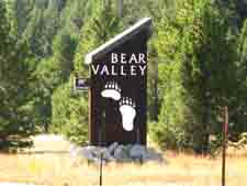 Above: Distinctive Bear Valley Road sign. We can't miss it! |
Bear Valley Deli 3 miles West of Lake Alpine on Highway 4. The owner and staff are real nice folks, as are most of the local folks up here. |
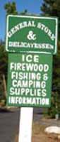 |
Great Folks at BV  Above: Distinctive Bear Valley Folks, as well as the terrain and signs... Denise Carter owns and operates the Bear Valley Deli and Grocery. |
Arnold
|
||
Full Service
|
||
|
FURTHER
South
on the
Trail Guide
| Trails Index Trail Guide Index |
Trail Guide Home Page Trailhead |
Contact
Alex Wierbinski
Lake Tahoe to Mount Whitney
Your guide to the Sierra Crest, including the Tahoe to Yosemite, Pacific Crest and John Muir Trails
