The Trails
Guide
Maps
Miles/Ele
Permits
Resupply
Forum
Current Weather Conditions
Weather Notes
Northern High Sierras
Central High Sierras
Southern High Sierras
Gear
Gear List
Gettin Started
Layering
Discussion
Testing yourself and your gear
Gear Reviews
Backpacking
The Carson Gap to the Carson Pass
Carson Pass
Hiking The Pacific Crest Trail South
to
Ebbetts Pass
or
North to Echo Summit
Languages
Languages
Trail Arts
The art of walking
Physical Preperation
Trail Skills
The trail
Off the trail
Scrambling
Maps
Navigation
Camp skills
Food
Resupply
Food
Other
Photo Catagories
Trail Stories
Trail Culture
News and Science
Links
Groups
Books
Terms and Conditions of Use
| Guide Index Carson Gap to Lake Alpine |
North PCT-TYT The Carson Gap |
South PCT Carson Pass to Forestdale Divide |
Topo Hiking Map Carson Pass Region |
NORTH Hiking Map South Upper Truckee to Carson Pass |
SOUTH Hiking Map Carson Pass to Ebbetts Pass |
Topo Map |
|
El Dorado National forest | Tahoe to Whitney on YouTube |
Carson Pass along the Pacific Crest Trail
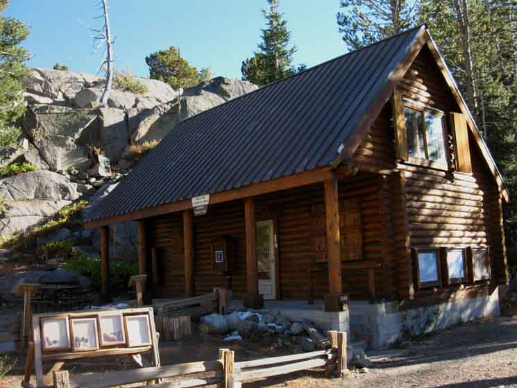
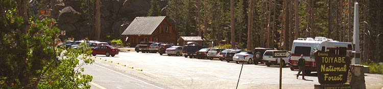
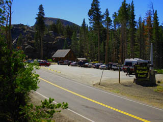
The Carson Pass Cabin has picnic tables, natural history, historical monumnents and bathrooms but no water.
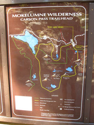
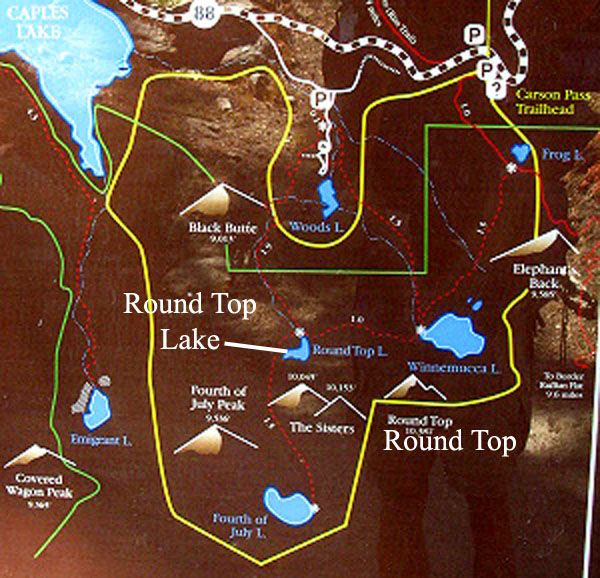
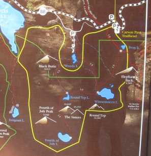
Carson Pass For Long Distance Hikers Carson Pass marks the point where the Southbound Pacific Crest and Tahoe to Yosemite Trails split into two distinct routes. Northbound long distance hikers find Carson Pass to be where these two routes finally rejoin again, after splitting apart in the Northwestern corner of Yosemite National Park. The Carson Pass Hiking Map depicts our three different options for turning off the Pacifc Crest Trail route following the Tahoe to Yosemite Trail South. Or not. Many hikers choose to hike South along the Pacific Crest Trail, others choose the Tahoe to Yosemite Trail. I suggest a long term hiking plan that includes both. Carson Pass for Local Hikers and Backpackers Carson Pass marks the point where Highway 88 crosses the Sierra Crest, offering Northbound day hikers and local backpackers easy access to Meiss Meadow within the Tahoe Basin to the North and Southbound hikers and backpackers access to the fine campsites around Round Top and Fourth of July Lakes within the Carson Pass Management Area. Tahoe to Yosemite Trail Hikers The most Eastern of the three possible routes to the Tahoe to Yosemite Trail from the Carson Gap runs through the Carson Pass from the Carson Gap to the point 1.04 miles South of Carson Pass along the Pacific Crest Trail route where TYT hikers turn Southwest through the Winamucca Lake Trail Junction. The "middle" route navigates to Winamucca Lake via Woods Lake and the Western Route follows the Lost Cabin Mine trail around (and above) the Western shore of Woods Lake. All three of these routes join at Round Top Lake for the hike into the Summit City Creek's great granite canyon. Combine these other two routes with the PCT route South out of Carson Pass makes for lots of local day hiking or local backpacking fun around the Carson Pass Management Area. The Carson Gap to Woods Lake trail guide page details the other two routes the TYT hiker can follow laying to the West of Carson Pass while the page below describes the Eastern route up to Round Top via Carson Pass and Winnemucca Lake. And the PCT route South to Ebbetts Pass. The remainder of this guide page continues South past the Winnemucca Lake trail junction along the Southbound Pacific Crest Trail to Forestdale Divide on our way to Ebbetts Pass on our long journey down to Mount Whitney. Trail Section Information
A "*" indicates that the overall elevation gain or loss does not reflect the total climbed and descended across this section of trail, only the aggregate. See the maps for specific elevation change details. Backpacker's Index
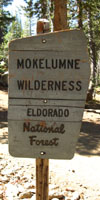
Mokelumne Wilderness Backpacker Resources and Hiker Information
POST UP! All backpackers can post text comments about the following section of trail through the comments links on all the trail guide pages. Registered Members can post up stand alone post about the trail with text, images, maps and videos in the Trails Forum that supplements this section of the Trail Guide. Check out the Tahoe to Whitney .org Backpacking Trails and Topics forums |
||||||||||||||||||||||||||||||||||||||||
This Guide is set up so that you can add your perspective & experiences here to broaden the trail guide's view of the Carson Pass and its backpacking opportunities. Check the Forum linked to every trail guide page for more information or to add yours. My perspective alone is insufficient to describe the terrain or the experience. Thus your perspective adds another dimension to the experience and value of this guide. Questions and comments always welcome. General Backpacking: Backpacker's Forum Home Page Specific Backpacking Trails & Topics: Backpacker's Forum This Location: Carson Pass |
Approaching the Carson Pass Southbound on the Pacific Crest Trail After making the Southbound descent down from the Carson Gap, passing the two unmarked junctions leading Southwest to the Tahoe to Yosemite Trail route via Woods Lake, we continue Southbound on the Pacific Crest Trail for a total of a mile and a third until we encounter the Northbound PCT trailhead of the Carson Pass. The Northbound Carson Pass Trailhead has its own parking lot and a bathroom equipped with a garbage can. This is located just North of the Carson Pass proper, and located on the North side of Highway 88, while the Carson Pass Cabin and its parking and bathroom are located on the South side of the highway. The unmarked trail junctions that you passed on your way down from the Carson Gap, and the facilities at the North Carson Pass trailhead are shown on the video clip below. The Carson Pass's Position between Lake Tahoe and YosemitePCT Mileages North of Carson Pass Into The Tahoe Basin Carson Pass is 12 miles South of Echo Summit on a combination of the PCT/TYT/TRT Trails Carson Pass is 42.71 miles South of Meeks Bay on the PCT/TYT/TRT Trails Note: At the Northern limit of this guide the Southbound TYT joins the PCT and TRT just a bit North of Middle Velma Lake on the far North end of Desolation Wilderness. Hiking North into the Tahoe Basin the TRT joins the PCT and TYT at Meiss Cabin. PCT Mileages South of Carson Pass Into The Mokelumne Wilderness of the Toiyabe National Forest Carson Pass is 26.78 miles North of Ebbetts Pass on the PCT 56.22 miles North of Sonora Pass on the PCT 130.02 miles North of Tuolumne Meadows on the PCT
Pacific Crest Trail distance from Lake Tahoe to Tuolumne Meadows Meeks Bay to Tuolumne Meadows following the PCT route spans 172.73 miles |
Driving to Carson Pass: Road Map to Carson Pass
Carson Pass is an excellent stand-alone trailhead for beginning backpackers
View my Sierra Road Maps Collection
Roadwork Staging for a trip out of Carson Pass The Carson Pass Road Map, above, is marked to point out various backpacking trail locations on the Tahoe to Yosemite and Pacific Crest Trails in relation to Highway 88 and the Carson Pass. It will also help you find your way to Carson Pass by car, if you want to start a backpacking trip from here. Carson Pass can be used as a trailhead for accessing Meiss Country to the North, the Tahoe to Yosemite Trail to Lake Alpine to the Southwest, and the Pacific Crest Trail to Ebbetts Pass to the Southeast. You can also backpack and hike all around Carson Pass within the Carson Pass Management Area. The google map is also marked with the free car camping options between Carson Pass and Woods Lake, as well as the access points for the roads to Blue Lakes and the extensive free car camping out there. These roads, the Forestdale Creek Road and Blue Lakes Road, will give you access to free car camping along the series of lakes South of the Blue Lakes, West of, and parallel to the Pacific Crest Trail route. car camping comments or questions? Car Camping Carson Pass Region The road map above has also been marked for car campers to help you find the many free National Forest car camping sites that sit along the dirt road between Highway 88 West of Carson Pass and the paved road to Woods Lake. The map also depicts the two roads East of Carson Pass that lead to free car camping opportunities South of Blue Lakes. Zoom into the Carson Pass region to differentiate the map markers. Since many of you urban dumb-asses bought four-wheeler SUVs, (jeeze!) this map also shows you a few places that you could actually use them. Forestdale Road to Upper Blue Lake is one such road. Well, it's a little steep at the Forestdale Divide, though well driven two-wheelers can easily get through this well-maintained dirt road. In fact, a beater car with an excellent driver can get places an idiot in a four-wheeler cannot. This does not mean that you or your car can get through. Conditions change from day to day, and season to season, so I make no promises about the condition of these roads or your safety on them. But the pressing question today is how to pay for the gas these beasts consume! Funny how people are working for their material possessions, rather than their possessions working for them... It is always Good Policy is to have a shovel, come-along, jack, some chain, and whatever else you find prudent to dig, drag, or push a stuck car out of trouble. If it is not possible to extracate your car, you will be really happy you packed enough food, water, and camping gear to safely hike out for help... These cool free car camping sites between Carson Pass and Woods Lake can be accessed through the dirt or paved roads to Woods Lake, and do not require four-wheel drives. But be forewarned: these sites are very popular, especially during the Summer Holidays. I have seen and talked to members of family groups who come up five days before the holiday to get their favorite site, and enjoy some quiet camping before their family camping group arrives. These free car camping sites are located exactly where the arrows are pointing to the "dirt road" on this topo map of the Carson Pass region.
Forestdale Creek and Blue Lakes Roads to free car camping South of Blue Lakes to Wet Meadow Reservoir Forestdale Creek Road There are two roads to the Blue Lakes from Highway 88. They are Forestdale Creek Road and Blue Lakes Road. Forestdale Creed Road breaks off from Highway 88 a couple of miles East of Carson Pass on the East side of Red Lake. Forestdale Creek Road is a dirt road that leads to the Upper Blue Lake via Forestdale Creek over the Forestdale Divide. South of the divide Forestdale Creek Road drops down to meet the paved Blue Lakes Road on the North Side of Upper Blue Lake. Follow the Blue Lakes Road to exit the Blue Lakes towards Highway 88. As you approach the top of your climb away from the Blue Lakes, you will see the road on your right, the South side of the road, leading to the Tamarack trail head. Beyond the trailhead parking this road leads to a series of dirt roads that access the real pretty series of lakes between Tamarack Lake to Wet Meadow Reservoir. Blue Lakes Road The Blue Lakes Road is a paved road that links Highway 88 to the PGE campground and facilities at Blue Lakes. This is your second option, your paved option, to access the free car camping sites Southeast of the Blue Lakes described above. The Blue Lakes Road is accessed 2.5 miles to the West of the junction between Highways 88 and 89, as you can see on the road map above. After climbing out of Border Ruffian Flat driving towards Blue Lakes you will begin to descend towards Lower Blue Lake. As you begin to descend you will see the road to the Tamarack trail head on your left, on the South side of the road. Past the Tamarack trail head there are is a dirt road who's branches lead to the backsides of all the lakes between the Blue Lakes Road down to Wet Meadow Reservoir. This road will bring you down to nice free car/truck camping sites on the Southwest side of Tamarack, and all of these beautiful Lakes. Check out this Topo Map from the Stanislaus National Forest of this section of the Mokelumne Wilderness. This section sits within the Toiyabe National Forest. Call the Carson Ranger District of the Toiyabe National Forest for more information, and to check the status of these roads. You will likely need to pick up a fire permit. If you drive out there and car camp, clean up your mess. Hell, if you drive out there, clean up any mess you find. Too many people who drive to these areas do not clean up after themselves. Those of you who are good car campers should clean up after the bad ones. I carry as much trash off the trails and campsites as I can. All of these road junctions with Highway 88 are marked on the google map above. |
The Carson Pass as a Stand-Alone TrailheadRather than passing through Carson Pass backpacking your way North or South, the Carson Pass can also serve as a stand-alone trailhead for many excellent long and short backpacking trips. I've seen many kids and people in their 80s hiking up to Round Top Lake and doing short backpacking trips in the Carson Pass Management Area. To the North from Carson Pass you have the PCT route into the Lake Tahoe Basin towards Echo Summit, and on to Meeks Bay along the TY Trail. (map) To the South of Carson Pass you have both the PCT and Tahoe to Yosemite Routes to Highway 4. (PCT map) (TY map) Around Carson Pass you have many beautiful short routes for day hiking and short backpacking trips around Round Top in the Carson Pass Management Area, (Carson Pass map) though you can cross the busy Round Top to explore the isolated, unmaintained trail to Lake Alpine along Summit City Creek. More Information about Local Camping in the CPMA below. |
Hiking South to Carson Pass on the Pacific Crest Trail
Video Below: Exiting the Tahoe Basin Southbound on the Pacific Crest Trail through the Carson Gap towards Carson Pass Showing the two junctions to the Tahoe Yosemite Trail on the South side of the Carson Gap, then hiking South into the Northbound Trailhead for the PCT just North of Carson Pass, which is equipped with bathrooms and garbage cans. Shortly South past this North Carson Pass trail head you will hike into the Carson Pass proper. |
Heading South from the Carson Gap on the Pacific Crest Trail
Your point of departure from the Tahoe Basin Southbound is through the Carson Gap. The Carson Gap is the low point in the ring of mountains marking the Southern extent of the Lake Tahoe Basin. The Carson Gap is a mile and a third North of Carson Pass along the Pacific Crest Trail route. South from the Carson Gap towards the Carson Pass on the Pacific Crest Trail you will pass two unmarked trail junctions. These junctions track Southwest, to your right, and both head down to the same place on Highway 88. You can use either of these unmarked trails to link up with the Tahoe To Yosemite Trail Route to Round Top Lake via Woods Lake. The first junction is just South of the Carson Gap, and heads straight down from the Carson Gap to Highway 88 by the most direct route possible. The second junction is at the bottom of the steep part of your descent South out of the Carson Gap, at the point you stop steeply descending. This is where the PCT turns East to pass around the last shoulder coming off of Red Lake Peak that separates this position from the Northbound Carson Pass Trailhead. |
Continuing South on the PCT for a mile past the second of these two unmarked junctions, you will pass into the parking lot and trailhead for Northbound Hikers on the PCT out of Carson Pass. This area also serves as an overflow parking lot for Carson Pass. The Carson Pass, the Carson Pass Cabin, and the Southbound trailhead for the Pacific Crest Trail sits about 200 yards further South on the South side of Highway 88. The Northbound Carson Pass trailhead sits on the North side of Highway 88, about 200 yards to the Northwest of the Carson Pass Cabin and Monument. |
Hiking South along the Pacific Crest Trail out of the Tahoe Basin through the Carson Gap soon brings us down to the first of two trailheads at Carson Pass. The first trailhead Southbound hikers encounter is the North Carson Pass Trailhead, pictured below. This trailhead, parking lot and bathrooms are located on the other side of Highway 88, the North side, and a few yards to the West and a bit below Carson Pass. Carson Pass Cabin, bathrooms, parking and the Southbound PCT trailhead are located a few yards further East and on the South side of Highway 88 |
Northbound Carson Pass Trailhead
Hiking South into the Carson Pass' Northbound Trailhead
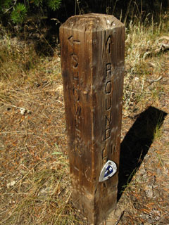
| Trail Post at the Northbound trail head at the lot North of Carson Pass. | This sign sits by the Northbound trail head, and is exactly the same as the one that sits by the Southbound trailhead at Carson Pass. | |||
 |
 |
|||
Next to the trailhead there is a nice picnic table. As there is a bathroom and garbage can here, it makes a nice place to take a break. The Northbound Trailhead from Carson Pass sits about 200 yards North of Carson Pass proper. |
||||
| The post points North to Showers and Round Lakes in the Meiss Country Roadless Area. |
Carson Pass on the Pacific Crest TrailCheck this location on the Carson Pass Region Topo Map Miles and Elevations South: Carson Pass to Ebbetts Pass Miles and Elevations North: Echo Summit to Carson Pass |
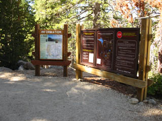
Backpacker Resources at the North Carson Pass Trailhead
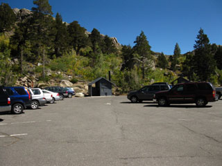
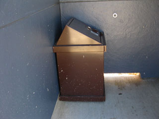
| Looking Northeast at the Northbound Trailhead's parking lot, with the bathroom in background. | Inside the bathroom sits a garbage can. | |||||
 |
 |
|||||
| The Northbound trailhead is to our left, and Carson Pass is a couple of hundred yards further South, to our right, along a well marked trail along the North side of Highway 88. | It's just treasure within treasure for backpackers at the N. Carson Pass Trailhead! |
Just South of the Northern Carson Pass Trailhead, shown above, we arrive at the Carson Pass
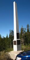
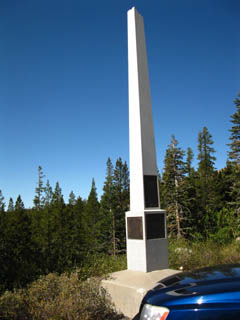
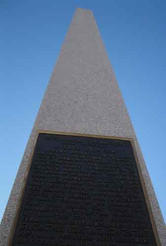
| Approaching The Carson Pass Southbound on the Pacific Crest Trail from the North Carson Pass trail head. | The Carson Pass Monument to Snowshoe Thompson |
|||
 |
 |
|||
Elephant Back sits behind the Carson Pass Cabin. The Southbound PCT passes to the Left of Elephant Back. The Southbound PCT trail head is next to the right side of the cabin. |
||||
| Erected by the Native Sons of the Golden West |
text below
Snowshoe Thompson
(John Tostensen)
A TRUE PIONEER
"...There ought to be a shaft raised to Snow-Shoe Thompson: Not of Marble; Not carved and not planted in the valley, but a rough shaft of basalt or of granite, massive and tall, with the top ending roughly, as if broken short, to Represent a life which was strong and true to the last, and this should be upreared on the summit of the mountains over which the strong man wandered so many years, as an emblem of that life which was worn out apparently without an object..."
---
Attributed to: Dan Dequille,
Territorial Enterprise, May 19, 1876
Dedicated July 1977
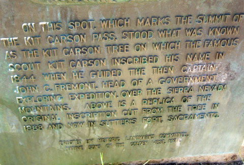
Kit Carson Tree Carving Monument
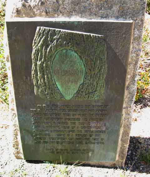 |
Did Carson and Fremont cross over Carson Pass or Forester Pass just to the Southeast? Did Fremont spot Lake Tahoe from the peak of Freel or Red Lake Peak? See the High Sierra History forum for links to sources that discuss these issues and lay out early American exploration of the High Sierra. |
| Kit Carson Tree Monument text | ||
 |
||
| Native Sons of the Golden West |
Trail History High Sierra Historical Monuments Tahoe to Whitney History Forum Check historical notes about Kit Carson and John Fremont in the Carson Pass area during 1844, read about disputes over the location of the Kit Carson Tree, and which local mountain Fremont climbed to be the first Westerner to observe Lake Tahoe on page 7 of the History of the Toiyabe National Forest. |
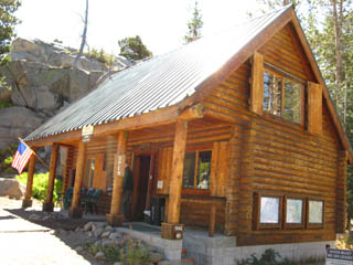
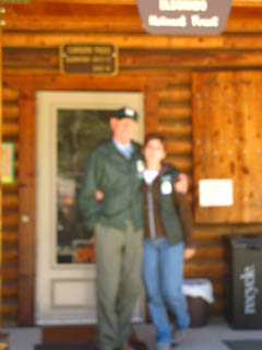
| The Carson Pass Cabin Summer Staff, 2009 | ||||
| The Carson Pass Cabin | ||||
| The permit drop box is a mail box affixed to the West corner on the backside of the Carson Pass Cabin. | ||||
 |
 |
|||
Permits for trips into the CPMA, as well as longer trips up and down the Pacific Crest and Tahoe to Yosemite Trails can be obtained here. |
||||
Craig Downing and Claudette Correia, Volunteer Staff at the Carson Pass Cabin. Thanks Craig and Claudette! |
Southbound Trailhead out of Carson Pass
| This is the Southbound Trailhead for the Pacific Crest Trail at Carson Pass. It sits on the West side of the Carson Cabin. There is also a nice shaded picnic table here. | ||
 |
||
| The Northbound trailhead for the Pacific Crest Trail is located about 200 yards North of Carson Pass. See the video at the top of this page, or the region map to locate the Northbound trailhead. |
Southbound trailhead for the Pacific Crest Trail from the Carson Pass
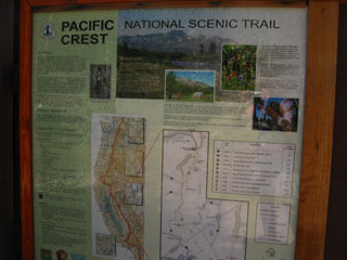
| Map of the limits of the Carson Pass Management Area, marked in yellow. | Pacific Crest Trail information at the Southbound PCT trailhead from Carson Pass. | |||||
 |
 |
|||||
| Local Permits for this area can only be obtained at the Carson Pass Cabin. See below for more information. | This is an excellent trailhead for backpacking trips to Ebbetts Pass, Sonora Pass, or Tuolumne Meadows. |
Also See: The Carson Pass Region Topo Hiking Map
and the Carson Pass Management Area Information
Southbound Options to Highway 4 from Carson PassEbbetts Pass is the next highway crossing hiking the Pacific Crest Trail South from Carson Pass. Ebbetts Pass is about 22 miles to the East of Lake Alpine, where the Tahoe to Yosemite Trail route crosses Highway 4. This page, and those that follow to the South will bring you to Ebbetts Pass along the Pacific Crest Trail, accompained by maps, pictures, and videos along with miles, elevations, and a written account. If you wish to follow the Tahoe to Yosemite Trail to Lake Alpine on Highway 4 you may do so from the Carson Gap page of the trail guide. From this page you can follow either the Tahoe to Yosemite or Pacific Crest Trail South to Highway 4. You are welcome to add your own pages to the Carson Pass to Ebbetts Pass Forum, which requires Registration, or decorate the existing Forum pages with your comments and questions, which does not require anything but your thoughts. The Lake Alpine Lodge is your next possible point to Resupply on the Pacific Crest or Tahoe to Yosemite Trail South of Carson Pass. |
The Carson Pass for Southbound HikersAs you have already walked the 1.39 miles South from the Carson Gap to the Carson Pass, you have most likely decided to head South on the Pacific Crest Trail towards Ebbetts Pass, rather than following the Tahoe to Yosemite Trail to Lake Alpine. As indicated on the Carson Gap trail guide page, Southbound hikers on the Tahoe to Yosemite Trail do not have to pass through Carson Pass. The first and second trail junctions for the Tahoe to Yosemite Trail are just a short distance South of the Carson Gap. But you still can hike down to the Carson Pass and turn West to connect with the Tahoe to Yosemite Trail at the Winnemucca Lake Junction, which sits a mile South of Carson Pass. The Winemucca Lake Junction is almost your last chance to make your way South along the Tahoe to Yosemite Trail. I say almost your last chance, because if you really wanted to expand your Tahoe to Yosemite Trail mileage, you could continue South on the PCT to the trail junction in the Forestdale Divide, then head Southwest down to Summit City Creek to pick up the TY route there. (Map: see the Right Side of the map where trails to Summit City Creek come down from Foresdale Divide.) Check the Carson Pass Region Map, the route discussion on the Carson Gap page, the discussion of route options on the Tahoe to Whitney Forum, and trail guide index pages for discussions and details necessary to consider and balance all your Southbound trail route options out of the Carson Gap. I suggest that you explore both routes over time.
Carson Pass Elevation: 8600 feet Mileage: 0 point for measurement South to Ebbetts Pass. Check the miles and elevations index for distances North and South on both trails.
Northbound Hiker Resupply Options at Carson Pass:More TravelThere are no services at Carson Pass, but if you are really short of food you can easily hitch a ride from here into the Tahoe Basin and the full backpacker services available at South Lake Tahoe. If you are really short on food and want to continue North to your resupply point at the Echo Lake Chalet, I'm sure you can bum some food from the typically overpacked backpackers who frequent the CPMA. This is almost always an option. Inexperienced backpackers generally carry much more food than they can possibly eat during their trips. That fact has saved my fat ass more than a few times over the last few decades. Or, you can continue the 12 miles further North to Echo Summit, where Highway 50 crosses the trail almost within view of South Lake Tahoe, to make the short hitch down to South Lake Tahoe to resupply from Echo Summit. Many long distance Pacific Crest Trail backpackers plan an extended rest and resupply session at South Lake Tahoe. It's also a good place to meet up with the boy-or-girlfriend (wife or husband) for a couple of days... You can also continue to hike two more miles North from Echo Summit to pick up your resupply package at the Echo Lake Chalet. Your use of any of these options depends on your plans, and how they work out. The closest exit point hiking to "civilization" from Carson Pass is the South Upper Truckee trail head in Meyers, at 8.42 miles South of Carson Pass. The trailhead is at the end of the South Upper Truckee Road, which will require about a 2 mile hike out to Portal Road and Highway 89, where you can easily hitch a ride into Meyers and on to South Lake Tahoe. Let's get back to Carson Pass. To Hitch out of Carson Pass You hitch East for 8.6 miles on the twisting, descending Highway 88, to the well marked Junction with Highway 89. Turn Left at this junction to follow Highway 89 eleven miles North over Luther Pass, which marks your entry into the Lake Tahoe Basin, to the junction between Highways 89 & 50 at Meyers. Located on the North side of Highway 50 just East of the Highway 50 & 89 junction is the Meyers Downtown Cafe. These people are great, and have great food for reasonable prices. I've been ending Winter trips here for quite some time. From the junction of Highway 89 and 50 in Meyers it is 4.7 miles East on the combined Highways 89 & 50 to the "Tahoe Y," where motel row, full service grocery stores, resturants and liquor stores are located. Highway 50 turns East at the "Tahoe Y" to follow the South Shore of Lake Tahoe to the California-Nevada stateline, while Highway 89 heads North along the West Shore of Lake Tahoe to connect with Highway 80 on the North side of Lake Tahoe. There is a row of hotels just West of the Tahoe Y. I suggest the High Country Lodge, which can be viewed on the South Lake Tahoe Resources page along with more information, maps, and a basic list of the extensive services available at South Lake Tahoe. All of these services, including the local Blue-Go bus service are within easy walking distance from the High Country Lodge. Check out this google map showing you these locations, and many more backpacker resources in the South Lake Tahoe region. Walking to South Lake Tahoe to Resupply Yourself: South Upper Truckee If you want to walk into the Tahoe Basin to rest and resupply at South Lake Tahoe, you can easily do this. After passing Northbound through the Carson Gap and hiking into Meiss Meadow, take a Right, to your North, at the Round Lake trail junction at Meiss Cabin. Head down mountain for six miles to reach the South Upper Truckee Trailhead in Meyers. The South Upper Truckee Trailhead is 8.42 miles North of Carson Pass. From the South Upper Truckee trail head I would try to hit up a local for a ride to South Lake Tahoe, or at least out to Highway 50 in Meyers. The South Upper Truckee trail head is well-used by local hikers, joggers, bikers, and even the local kids come out to hang out here. But you may have to walk a couple of miles to the junction of Portal Road and Highway 89 where hitching backpackers can easily get a ride from other sportsmen returning from Carson Pass, Kirkwood, or the Eastern Sierra. The Echo Summit to Carson Gap Map lays out the position of the South Upper Truckee trailhead in relation to nearby streets. I highly suggest that you follow the road to the West, rather than the unmaintained section of road that climbs up to Highway 89. You will have better chances of getting rides following the maintained road out through the housing, rather than the unmaintained road up the highway. These Tahoe Basin trailheads, when used to access the trails out of the Tahoe Basin to Round Top and the Carson Pass, can be crafted into many fine short or medium length backpacking loops around the Southeast of the Tahoe Basin to Carson Pass and back. |
North: Carson Gap South on the PCT: Carson Pass to Forestdale Divide
The Carson Pass on Highway 88 |
|||||||
After making the Southbound descent down from the Carson Gap, passing the two unmarked junctions to the Tahoe to Yosemite Trail via Woods Lake, and continuing down the Pacific Crest Trail for a bit over a mile, you will encounter the Northbound PCT trailhead, parking lot, and bathroom, as seen in the video clip at the top of this page. A couple of hundred yards further South sits the Carson Pass proper, where the Southbound Carson Pass's Pacific Crest Trail trailhead is located. The trailhead continuing South on the Pacific Crest Trail is located on the West side of the Carson Cabin.
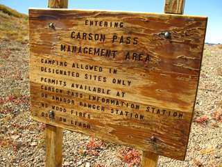
The Carson Pass Management Area Carson Pass is a busy trailhead, not so much for the considerable Pacific Crest Trail traffic that passes North through here every year, but because the Carson Pass Management Area is a year-round local's favorite for hiking, cross-country skiing, and short backpacking trips. This heavy usage stimulated the Forest Service to form the Carson Pass Management Area, create designated campsites within its bounds, and require all backpackers using this area to obtain permits at the Carson Pass Cabin for a specific camping locations in the CPMA. There is an exception to this strict policy for through backpackers hiking in from other permitting authorities. Detail of Carson Pass Management Area Map
Through hikers may camp in the CPMU if their permit specifies that they are spending a night at a named location within the CPMU. I almost always specify a night at "Round Top Lake" when my hiking plans put me anywhere near the CPMA. The Tiny Extent of the CPMU
The yellow line on the map above defines the Carson Pass Management Area, which is bound by these signs:
The green line marks the boundary of the Mokelumne Wilderness. What this means to Long Distance Backpackers South and Northbound backpackers on the Pacific Crest Trail do not have to worry too much about the camping restrictions at the Carson Pass Management Area, as the PCT route just scrapes the Eastern edge of the CPMA. Most Pacific Crest Trail Hikers are just passing through a corner of the Carson Pass Management Area on their way to campsites to the North or South. On the other hand, (or foot!) the Tahoe to Yosemite Trail route passes right through the heart of the Carson Pass Management Area. When my long-distance hiking plan calls for me to spend a night in the Carson Pass Management Authority, I always have the authority issuing my permit (which is almost always the Lake Tahoe Basin Management Unit) to specifically note Round Top Lake or 4th of July Lake as one of my specific nightly campsite locations. As all wilderness management authorities and National Forests must honor long distance permits issued by another National Forest or management authority, as long as the permit names the location you plan on camping. When your long distance backpacking trip crosses "special zones," such as the Carson Pass Management Unit, naming your campsites is very important. If you have not named a campsite in the Carson Pass Management Authority on your permit, or are beginning a trip at Carson Pass, you must get a permit for camping in the CPMA at the Carson Pass Cabin. If you pass through the Carson Pass Management Area on a weekend during the Summer season, the chances are good that there will not be any more permits available. This is a busy place, so do plan ahead.
Nearby Campsites NORTH To the North of Carson Pass there are campsites in Meiss Meadow just South of Meiss Cabin (Less than 3 miles North of Carson Pass), at Meiss Lake just a short distance N of Meiss Cabin, and excellent sites a few miles North of Meiss Cabin at Showers Lake (Less than 5 miles North of Carson Pass. Oh, and there is a nice place to camp on the way South to Meiss Meadow coming down from the Carson Gap. Look to your left about three-quarters of the way down to the Meadow from the Gap. You will see a nice site protected by trees sitting above the creek. Note: Click the Colored Dots on the Maps! SOUTH To the South of Carson Pass there are good campsites at Lost Lakes (7 miles South of Carson Pass) and Tamarack Lake (11.5 miles South of Carson Pass). The series of lakes between Tamarack Lake and Wet Meadows Reservoir have many nice campsites. Carson Pass to Ebbetts Pass Map Note: Click the Colored Dots on the Maps!
Local Backpacking Trips You can start many excellent long and short distance backpacking trips out of the Carson Pass Management Area. To the North of Carson Pass the Pacific Crest Trail tracks across the Carson Gap into Meiss Meadow, and continues on to Echo Summit via Showers Lake. From Meiss Meadow one can choose to follow the Round Lake trail down past Round Lake to the South Upper Truckee Road in Meyers, or branch off at the Big Meadow trail junction to follow this part of the Tahoe Rim Trail through Meiss Country to exit at the Big Meadow trailhead on Highway 89 sitting to the North of Luther Pass. To the Southwest of Carson Pass sits the jewel of the CPMA, Round Top and The Sisters, with Round Top lake nestled under the ridge arms of the massif's crestline. In recent years the heavy use of this beautiful area caused the CPMA to be formed. They laid out a limited number of campsites and restricted the number of camping permits issued. I hiked through here many times before I took note of the CPMA, paid attention to its designated campsites, and finally visited the Carson Pass Cabin to take offical note of the many changes in permit policy the establishment of the CPMA ushered in. Through hikers who wish to stay here must name any campsite location in the CPMA on their permit.
Round Top Lake frozen in late Winter From Round Top Lake one can follow the Tahoe to Yosemite Trail around the mountain's Southwestern shoulder, shown above, to drop down to the Summit City Creek via Fourth of July Lake. Fourth of July Lake sits in a small ledge wedged on the flank of the mountain above Summit City Creek. Route options within Route Options From the trail junction in Summit City Creek one can turn Right, or Southwest, to follow the unmaintained sections of the Tahoe to Yosemite Trail towards Lake Alpine, or turn Left, and pass by the magnificent Devils Corral on your way to camp at Lost Lakes via Upper Blue Lake. From there you can head back to the Carson Pass via Forestdale Divide. A nice little loop. This route is good for a fine two or three day backpacking loop circling Round Top and the Sisters from Carson Pass. Or you can hook up with the Pacific Crest Trail and hike South to Ebbetts Pass. Through Hikers on the Pacific Crest Trail As mentioned above, there are excellent campsites both to the North and South of the Carson Pass Management Area on the Pacific Crest Trail. 7.5 minute hiking topo Map: Carson Pass to Lost Lakes 30 min hiking topo Map: Carson Pass to Ebbetts Pass Note: Click the Colored Dots on the Maps! Carson Pass to Ebbetts Pass Miles and ElevationsSouth on the PCT: Carson Pass to Forestdale Divide |
Backpacking Trail Guide North |
 |
Backpacking Trail Guide South |
Backpacker ForumsHave General Information about Backpacking to relate?Post it on: TahoetoWhitney.OrgYour comments and questions posted from this page appear on the Carson Pass Forum Page.Register to post your own stand-alone pages about your trips and the trails through the Mokelumne Wilderness in the Carson Pass to Ebbetts Pass Forum.Section: Carson Pass to Ebbetts PassLocation: Carson Pass |
North: Carson Gap South on the PCT: Carson Pass to Forestdale Divide
Trailhead
Contact Alex Wierbinski

Backpacking Lake Tahoe to Mount Whitney
Your guide to the High Sierra Crest, including the Tahoe to Yosemite, Pacific Crest, and John Muir Trails
