
The Trails
Guide
Maps
Miles/Ele
Permits
Resupply
Forum
Current Weather Conditions
Weather Notes
Northern High Sierras
Central High Sierras
Southern High Sierras
Gear
Gear List
Gettin Started
Layering
Discussion
Testing yourself and your gear
Gear Reviews
Tuolumne Meadows to Reds Meadow
Backpacking Maps Index
Pacific Crest and John Muir Trail Backpacking Maps
Languages
Translate
Trail Arts
The art of walking
Physical Preperation
Trail Skills
The trail
Off the trail
Scrambling
Maps
Navigation
Camp skills
Food
Resupply
Food
Other
Photo Catagories
Trail Stories
Trail Culture
News and Science
Links
Groups
Books
MAP |
MAP |
MAP |
REGION |
ALL |
GUIDE |
GUIDE |
GUIDE |
ALL |
MILES |
MILES |
ALL MILES INDEX |
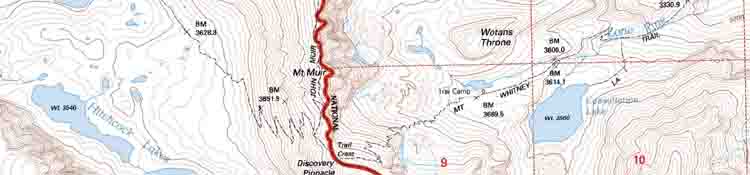
Trail Section The John Muir Trail NOTE
|
Topo Hiking Maps for Tuolumne Meadows to Reds Meadow |
||
7.5 minute
|
30 minute
|
|
| > Forum < | ||
| ROUTE OPTIONS NOTE |
North Maps: Sonora Pass to Tuolumne Meadows South Maps: Reds Meadow to Vermilion Valley
Backpacking Map
|
||||||||
Backpacking Map Information and Instruction
USGS MAP LOCATOR Free USGS Maps for Downloading
|
Backpacker Forums TW ORG has Backpacker's Trail Forums covering the Sections and Segments of the long distance High Sierra Trails between Lake Tahoe and Mount Whitney, what we will need to hike them.
Here's a few of my favoirite topics: Unidentified Hikers can post up comments in all the Trails and Topics Forums. Registered Members can post up their own pages in the forums. Add your experiences, comments, questions, and information about our High Sierra backpacking map. Trail Topic |