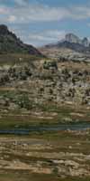
View from PCT of Kennedy Creek below Kennedy Lake flowing down West Flank to TYT at Summit Creek above
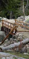
Kennedy Meadows Pack Station.
The Trails
Guide
Maps
Miles/Ele
Permits
Resupply
Forum
Current Weather Conditions
Weather Notes
Northern High Sierras
Central High Sierras
Southern High Sierras
Gear
Gear List
Gettin Started
Layering
Discussion
Testing yourself and your gear
Gear Reviews
Backpacking
Lake Tahoe to Mount Whitney
Section 4
TRAIL GUIDE INDEX
Backpacking South |
Languages
Translate
Trail Arts
The art of walking
Physical Preperation
Trail Skills
The trail
Off the trail
Scrambling
Maps
Navigation
Camp skills
Food
Resupply
Food
Other
Photo Catagories
Trail Stories
Trail Culture
News and Science
Links
Groups
Books
TWO |
|||||||||||||||||
|
|
This Page: Highway 108 Trailheads to Highway 120 ALL RESOURCES |
|
||||||||||||||
 BIG VERSION |
|||||||||||||||||
|
|||||||||||||||||
| Top of Page | |||||||||||||||||
TYT & PCT
|
|||||||||||||||||
|
South Two
#2 |
| |||||||||||||||
The
|
|||||||||||||||||
BUT FIRST,
South
The 2 PCT & 1 TYT trailheads on Highway 108 at Sonora Pass are separated by about three-quarters of a mile. The two PCT trailheads bracket Sonora Pass while the single Northbound trail of the Tahoe to Yosemite Trail, coming South from Lake Alpine on Highway 4, ends at the Saint Marys Pass Trailhead on Highway 108 just about a mile West of Sonora Pass. To continue South, the hiker on the PCT just has to cross the Sonora Pass Highway to continue their hike. Not so for the Southbound hiker on the Tahoe to Yosemite Trail. The Southbound TYT hiker encounters Highway 108 at the end of a short but inconspicuous dirt road on the North shoulder of Highway 108 located about three-quarters of a mile West of Sonora Pass.
TYT & PCT
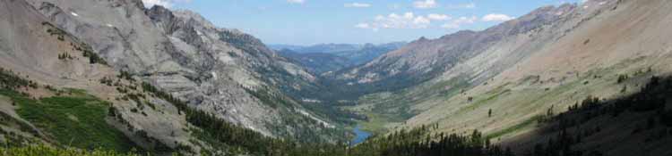
PCT South Dropping off the South flank of Leavitt Peak the PCT turns East off the Sierra Crestline into the Toiyabe NF at the top of Kennedy Canyon. From that point the PCT drops elevation and its route wraps around the Sierra Crestline where it crosses The High Emigrant Basin, which is wedged-in just below the West Flank of the Sierra Crestline. The line of the Sierra Crest continues running South across Emigrant Wilderness beyond the point where we Southbound PCT hikers turned East down Kennedy Canyon. The route of the PCT deflects off and around the Sierra Crest at the top of Kennedy Canyon, only to climb back to, and cross the Sierra Crestline passing through Dorothy Lake Pass into the North Yosemite Backcountry.
TYT South The Trail Guide Pages Listed Above
The Trail Guide Pages Listed Below Below the Below Post your reports and comments through the forums. TRAIL FORUMS
|
|||||||||||||||||
North Yosemite Backcountry TYT and PCT The Southbound Pacific Crest and Tahoe to Yosemite Trails join just below the top of Jack Main Canyon to share most of the remaining 54 miles of trail South to Tuolumne Meadows. The exception is the TYT divergence around Tilden Lake where the PCT loops around Wilmer Lake. |
|||||||||||||||||
|
|||||||||||||||||
|
|||||||||||||||||
Tahoe to Yosemite Trail
|
Pacific Crest Trail
|
||||||||||||||||
Fantastic local Backpacking Options The maps below show us we have the Tungsten Road and the Emigrant Pass Trails connecting the PCT with the TYT across the length of Emigrant Wilderness. These connector trails, including where the PCT and TYT come together in the top of Jack Main Canyon, give local hikers in the Emigrant-Toiyabe here lots of options to put together beautiful backpacking loops around the Highest Elevation portions of the Emigrant Wilderness and the adjacent Toiyabe National Forest. |
|||||||||||||||||
PCT-TYT Share route across North Yosemite
|
|||||||||||||||||
Top of Page
South to Yosemite
|
|||||||||||||||||
|
|
|||||||||||||||||
Emigrant Wilderness Hybrid Kennedy Canyon to Grizzly Peak Linking the Pacific Crest Trail to the Tahoe Yosemite Trail through The Emigrant Basin, to Bond Pass. The trail junction at Grizzly Peak in the High Emigrant Basin acts as a hub for trails from all compass points around the Emigrant Wilderness. Read, or add your own hiker's comments about this section of Trails and the Trail Segments it contains. Route Options Discussion: |
|||||||||||||||||
Resupply
|
|||||||||||||||||
TRAIL GUIDE INDEXES
North & South
|
Contact
Alex Wierbinski
Lake Tahoe to Mount Whitney
Your guide to the Sierra Crest, including the Tahoe to Yosemite, Pacific Crest and John Muir Trails
