
High Sierra
Backpacking
Trail Guide
Forums
Sierra
Weather
WeatherNotes Northern
Sierra Weather
Gear
Backpacking
Meeks Bay to Echo Summit
DESOLATION WILDERNESS
HIKING MAPS
Backpacking Topo Maps
Index
Starting
the
Tahoe to Yosemite Trail
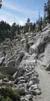
Hiking the Length of the Desolation Wilderness
Languages
Trail Skills
Mountain
Safety
Food
Planning
Trail Arts
More
Information
Social
ALL |
MAP |
MAP |
REGION TYT-PCT |
LOCAL |
MILES TYT-PCT |
TRAIL TYT-PCT |
TRAIL |
||
| MEEKS BAY to DICKS PASS |
DICKS PASS to LOWER ECHO LAKE |
||||||||
|
The Meeks Bay Trailhead |
||
| 11.5 miles South of the Tahoe to Yosemite Trailhead at Meek Bay we join the
Pacific Crest and Tahoe Rim Trails for the rest of our hike South through the Desolation Wilderness. |
||
| 7.5 minute USGS Detailed Backpacking Maps 1:24 000 |
30 minute USGS Region Backpacking Maps 1:100 000 |
|
The 7.5 minute series are detailed Topo maps of each segment of the Tahoe to Yosemite Trail between Meeks Bay and Echo Summit across the length of Desolation Wilderness.
North Desolation Wilderness Region
Tahoe to Yosemite Trail
Tahoe to Yosemite Trail
Lake Aloha
Tahoe to Yosemite Trail
Tahoe to Yosemite Trail
|
Below we have a series of large-scale 30 minute maps to put our trail routes within the overall context of the terrain. First we start with the raw 30 minute map FULL Click the map above for detailed maps.
The next map below is a huge 30 min map with the Tahoe to Yosemite Trail marked out between Meeks Bay and Echo Summit above the West Shore of Lake Tahoe. Scroll over the map above to find links to the detailed maps of our TYT-PCT-TRT routes. Clicking Red Dots brings us to the
Below are smaller 30 min map segments. They give us an idea of the overall terrain beyond the trail than the narrower scope of the 7.5 min maps. NORTH DESOLATION WILDERNESS
SOUTH DESOLATION WILDERNESS Mouse-over these maps to locate the underlaying detailed maps. |
|
This collection of 7.5 and 30 minute maps, along with a couple of 1 X 2 degree maps thrown in, are designed to give us levels of resolution to understand these trails in the context of their surrounding terrain. The big maps provide an overall perspective of the surrounding terrain highlighting local trailheads and the potential for loops and in-and-out trips into Desolation Wilderdenss along the TYT and PCT routes. The 7.5 maps give us a detailed look at each segment of the trails. |
||
Maps North: NONE Maps South: Echo Summit to Carson Pass
What's Up? The TYT, PCT, and TRT in the Lake Tahoe Basin Terrain First we hike South across the length of Desolation Wilderness's grand granites to Highway 50. Crossing 50 we find granite now shrouded under dense forests, and we find the limit of the range of the granite terrain crossing the interface into the volcanic terrain wrapping around the Southern end of the Tahoe Basin. Trails The TYT and PCT continue South together through the junction to exit the Tahoe Basin through the Carson Gap. The TRT turns Northeast here at Meiss Cabin, remaining within the Tahoe Basin for the hike up into the Carson Range along the Eastern Shore of the Tahoe Basin via the Big Meadow Trailhead. Red Dots link to Trail Guide Entries Red Dots link to Detailed Maps FORUM Each trail Guide page provides specific information about that particular location, including mileage and elevation information, nearby features, lots of pictures, some videos, a written description, and a link to the Trails Forum for that location. Vortext of Experience This can be as mundane as a series of blisters, sore muscles, and the minor strains and pains of getting the body hard for the mountains as we apply ourselves to nature. In the background of this series of pains is the evolution of our personal experience as our struggle to complete challenging hikes consolidates into a well of enduring strength and capacity. In the meantime our increasing strength and decreasing pain is giving us greater views We've got to look through a clear lens if we want a clear view. Many perspectives and experiences about a trail builds much better understanding than a singular perspective. The comments links on each page lead to the forum for that specific location. Add your perspective. Your addition of side trips, loops, scrambles, and just basic advice and shared experience about the places you are familiar makes for a better trail guide. |
Lake Tahoe to Carson Pass Maps Index |
Map Credit |
||
U.S. Geological Survey, Department of the Interior I love the USGS, as you can see from the I also dig the NWS, as you can see from our We gotta know the terrain under our feet, and the weather over our heads in the sky. These are the basics. In fact, we can use the USGS to set us up to plan and hike anywhere in the US of A. First, go to the Move the Map to the Sierras. Or your favorite backpacking spot in the US of A. Navigate the map to the area you wish to locate maps. The list of available maps appears for that square are listed Select the maps that will help you plan and execute your backpacking trip, set up a directory on your computer named for the trip or location of the maps, and begin downloading those suckers. Open your USGS maps with Adobe Reader. But first, we have to "unzip" the maps. I use 7zip. Custom Maps Printing At least one reader of Tahoe to Whitney has copied and printed out Tahoe to Whitney Maps with success.
That is totally cool for personal and non-profit uses. |
High Sierra Backpacking Map |
||||||||
Backpacking Map Information and Instruction
USGS MAP LOCATOR Free USGS Maps for Downloading
MAP NOTE What's important for our general reference purpose is that each side of a square is 1000 meters, or a Kilometer. From my point of view that is 1093 yards or .62 of a mile. Diagonal: 1414.22 meters, if my trig is correct. That converts the diagonal distance across a grid square |
Backpacker ForumsHave a great Sierra Nevada trip or story to relate? A fine piece of gear? Or gear that failed? Post it on Above we come to the Front Page of the High Backpacking Trails and Topics Forums. Below we break the forums down into categories:
The Trails Forum acts as your place to put up input, comments, relate your experiences, or ask questions about each segment and spot along the length of our combined TYT-PCT-JMT trails. The Forum is your place to supplement the trail guide. Anyone can post text comments in the existing forums, but only members can post up new topics, along with images, maps, and formatting. If you have experiences, comments, questions you can post up here as an unknown hiker. If you want to post up pictures and embed videos of the Tahoe to Yosemite and Pacific Crest Trails across Desolation Wilderness, you would have to be a member. Section
|
Maps North: NONE Maps South: Echo Summit to Carson Pass
Trailhead
Contact
Alex Wierbinski

Backpacking Lake Tahoe to Mount Whitney
Your guide to the High Sierra Crest, including the Tahoe to Yosemite, Pacific Crest, and John Muir Trails