

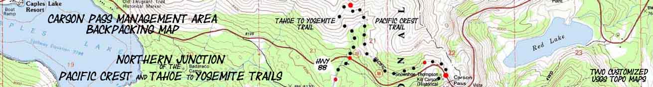
Carson Pass Backpacking Map
Hiking
Tahoe to Yosemite and Pacific Crest Trail
Backpacking Route Options at the Carson Pass
Two
7.5 minute USGS Backpacking Maps of the Carson Pass Management Area
| Pacific Crest Trail Maps and Miles |
Tahoe to Yosemite Trail Maps and Miles |
Trail Guide Pages |
Trail Guide |
Trail Information Indexes |
Weather, Map Data | |||||||||||||||||||
| PCT SOUTH SECTION MAP Carson Pass to Ebbetts Pass |
PCT |
ALL |
PCT |
PCT Maps INDEX SOUTH Carson Pass to Ebbetts Pass |
MILES and ELEVATIONS Carson Pass to Ebbetts Pass |
30 Minute |
7.5 Minute MAP SOUTH Summit City Creek to Bee Gulch |
7.5 Minute |
MILES and ELEVATIONS Carson Gap to Lake Alpine |
Decision |
Tahoe |
Pacific Crest Trail |
|
|
Maps Index Lake Tahoe to Lake Alpine |
ALL |
||||||||
| Pacific Crest Trail | Tahoe to Yosemite Trail | Trail Guide | ||||||||||||||||||||||
Carson Pass Region Backpacking Map
Southbound into the Mokelumne Wilderness of the El Dorado or Toiyabe National Forests
North into Meiss Country Roadless Area.
| TYT-PCT North map Meiss Country Roadless Area |
TYT South map Summit City Creek to Mount Reba |
click red dots | PCT South map Carson Pass to Blue Lakes |
PCT South map Mokelumne Wilderness Topo Map |
|
| TYT-PCT North map Meiss Country Roadless Area |
TYT South map Summit City Creek to Mount Reba |
click red dots & Map Labels |
PCT South map Carson Pass to Blue Lakes |
PCT South map Mokelumne Wilderness Topo Map |
Mapology |
||||
MAP NOTE What's important for our general reference purpose is that each side of a square is 1000 meters, or a Kilometer. From my point of view that is 1093.6 yards or .62 of a mile. Diagonal: 1414.22 meters, if my trig is correct. That converts the diagonal distance into 4,639.8 feet or .88 of a mile.
|
More Maps |
||||||
more 1 x 2 MAP South of the Tahoe to Yosemite and Pacific Crest Trails 30 MAP 7.5 MAP 7.5 MAP See the Tahoe to Yosemite Maps Miles and Elevations |
more 1 x 2 MAP South of the Pacific Crest and Tahoe to Yosemite Trails 30 MAP 7.5 MAP 7.5 MAP
See the Pacific Crest Trail Maps South Miles and Elevations |
|||||
CARSON PASS REGION ROAD MAP
Map Location |
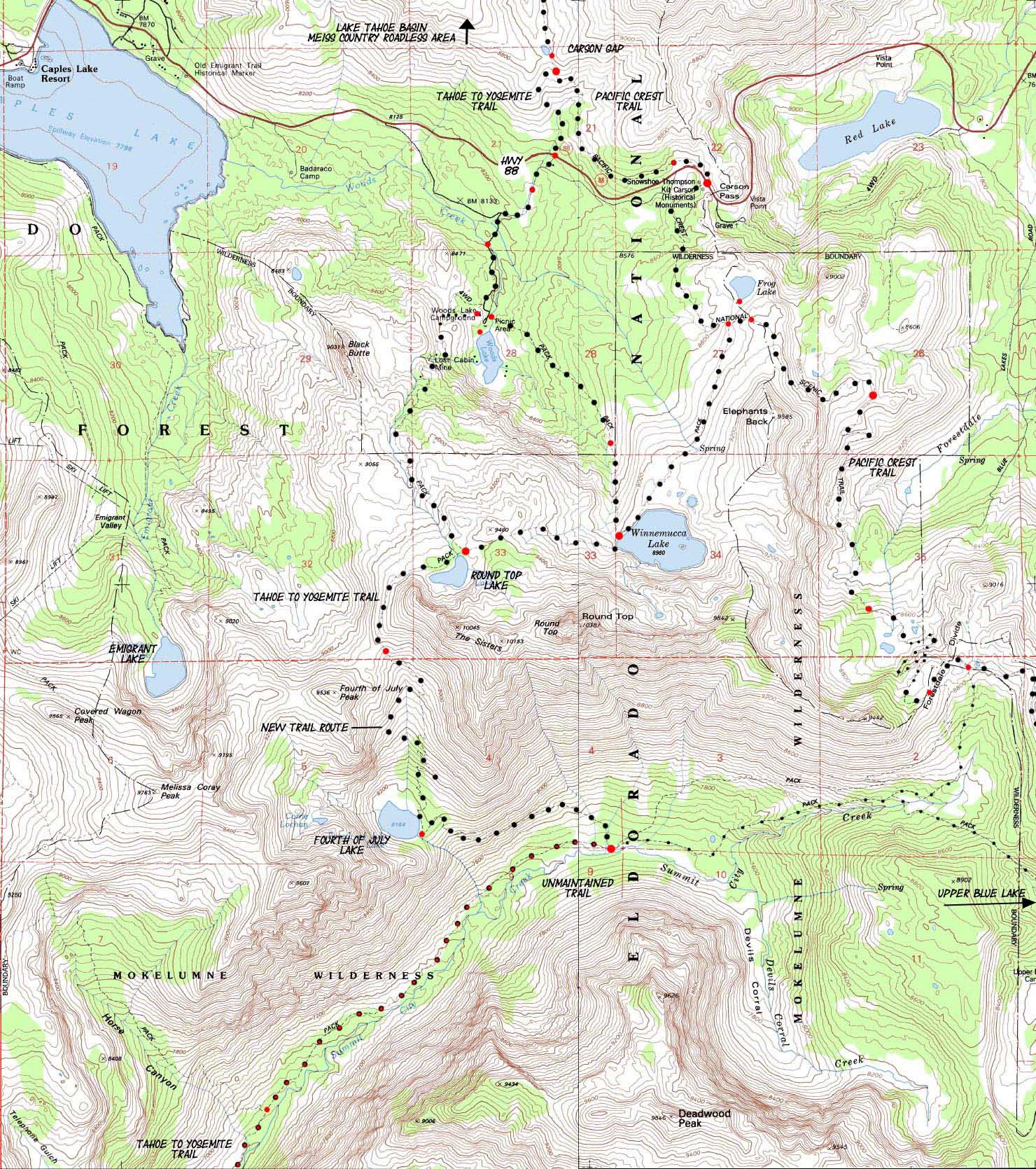
Carson Pass Management AreaThe map above lays out our hiking options for Tahoe to Yosemite Trail backpackers breaking off the Pacific Crest Trail through the Carson Pass Management Area. Main Terrain Features We've got two significant hiking route options from Highway 88 across the Mokelumne Wilderness South to Highway 4. The TYT Option Be careful crossing Highway 88 to the West of Carson Pass following the TYT. Our crossing point lays at the end of a bend in Highway 88 that is blind. Make sure you listen and watch carefully to the West for Eastbound cars, of which there will be many during Summer and ski seasons. Don't end your trip as road kill. That'd be ironic. Unmaintained Trail Well, as of 2013 the unmaintained trail North of the North Fork of the Mokelumne had more trail work done to it than I've seen for years. The maintained trail South of the North Mokelumne River has had lots of recent work done to it over the last 15 years, but early 2014 reports indicate this maintained segment of trail has some pretty sketchy sections full of dense manzanita. It was not too bad during the Fall of 2013. Read the latest we have and post up your recent experiences: TYT The PCT Option The Eastern and Western routes of the PCT and TYT South to Yosemite make these trails of very different characters. The Southbound routes of the PCT and TYT coming South out of the Lake Tahoe Basin split like the diverging prongs of a wishbone from their common exit point through the Cason Gap. The PCT tracks to the Southeast along the Eastern edge of the Mokelumne Wilderness while the TYT fist turns Southwest, then hikes South along its Western flank. Both routes South across the Mokelumne Wilderness are on their different routes to the Southern boundary of the Mokelumne Wilderness along Highway 4. The PCT crosses Highway 4 at Ebbetts Pass about 14 miles East of Lake Alpine, where the TYT crosses Highway 4 near our resupply spot at the Lake Alpine Lodge. The route of the TYT crosses Highway 4 through the Bee Gulch Trailhead on the Northwest corner of Lake Alpine about .75 of a mile East of the Lake Alpine Lodge. The Tahoe to Yosemite Trail After descending from the Carson Gap and crossing Highway 88 we will make our way towards Woods Lake first along a dirt road to the paved road to Woods Lake. Approaching Woods Lake we have two possible routes that can take us up to Round Top, the footbridge route to the East of Woods Lake or the Lost Cabin Mine route climbing around and above Woods Lake's Western shore. After getting down to an abandoned trailhead along the North side of Highway 88 we will see a dirt road next to a utility building over on the South side of the highway, a corrugated garage painted black. Crossing Highway 88 and looking East up the dirt road towards Carson Pass we see that this dirt road from Carson Pass to Woods Lake parallels Highway 88 coming West down from Carson Pass, which sits to our Southbound hiking left, to our East. We follow this road to the Right, for about a half-mile to where this dirt road connects up with the short paved road South to Woods Lake. About a half-mile past Highway 88 we will turn left off the dirt road onto the paved road to Woods Lake. A couple of hundred yards down this paved road we see a parking lot on our right where there's a National Forest toilet and garbage facilities. If you miss sitting on a real toilet seat, you are in luck. A couple of hundred yards past this parking lot, but before we reach Woods Lake we see a footbridge on our left. This footbridge leads us to the central of our three route choices leading up to Round Top Lake. The trail over this foot bridge takes us up to Round Top Lake via Winnemucca Lake. Up at Winnemucca Lake we intersect with our TYT trail option coming South from Carson Pass, and these unified trails turn West for the short climb up to the Round Top Lake trail junction. I made a video describing these three routes from the Carson Gap to the Round Top Lake trail junction. The video gives us an overview of the terrain covered by the map above, and points out the location of the three routes from the Carson Gap up to the Round Top Lake trail junction. In any case, looking at the footbridge means we must decide between the two potential routes up to Round Top and the Sisters we have available here from Woods Lake. We can either follow this "central" trail route across the footbridge up to Round Top via Winnemucca Lake, or take the shorter but steeper Western route, the Lost Cabin Mine Trail, which lays a short distance further South down the paved road towards Woods Lake. We continue past the footbridge if we're hiking the Lost Cabin Mine Trail up to Round Top, or if we are going down for a break at Woods Lake before crossing the footbridge. We quickly encounter the Woods Lake federal car campground off to our right. Enter the camp through the main entrance, and at the top of the paved campground loop road we find a trail cutting up between the top two campsites to the old jeep road leading left, South to the Lost Cabin Mine. The trail past this still active mine is the quickest but steepest route up to Round Top Lake. If you are not sure about what the hell I'm talking about, and the map above makes no sense to you, shoot me an email. The Woods Lake campground has a host, so you can ask the host for directions if you feel lost. But that's not a good sign for your navigation potential when the Tahoe to Yosemite Trail disappears from Summit City Creek to Camp Irene. PCT Carson Gap Review the trail guide pages linked through the map above for more information and details. That's clicking the red dots on the marked routes. The Lost Cabin Mine Trail intersects with the trail up from Winnemucca Lake at the Round Top Lake trail junction. The Round Top Lake trail junction is where all Tahoe to Yosemite Trail backpackers who hiked the 3 various routes up to Round Top Lake come together for the remainder of the hike South through the Mokelumne Wilderness to Lake Alpine. Me, before I continue South on the TYT I'm going to take off my pack and have a nice break next to Round Top Lake, staring at the lake sitting under the shadow of Round Top and The Sisters. This are a bunch of real nice place to sit and observe up on the Round Top and The Sisters Massif. Down the Backside Into Summit City Canyon Into the Heart of Darkness Blue Lakes and Forestdale Divide As we can see by the map above, there is a fine spider web of trails connecting the main routes of the TYT and PCT along the Sierra Crest where their routes connect across the Carson Pass Management Area. Many fine short local backpacking loop trips can also be crafted along these trails around Round Top and the Sisters. Thus this route up Summit City Creek towards Blue Lakes can be bent up to Forestdale Divide and North back to Carson Pass, allowing us to close the end of backpacking loops begun at Carson Pass or Woods Lake, or wherever we began hiking from in the CPMA. There are no trails connecting the TYT and PCT once we get South of the Summit City Canyon trail junction on the Tahoe to Yosemite Trail. Recap And, it is this difference between the two routes, with the Pacific Crest Trail tracking along the Eastern Flank of the Sierra Crest while the Tahoe to Yosemite route hikes the Western flank that gives each route the unique character across their very divergent routes. This East-West division between the Tahoe to Yosemite and Pacific Crest Trail routes will continue until they rejoin below Dorothy Lake Pass at the base of Bond Pass at the top of Jack Main Canyon just within the most Northwestern corner of Yosemite National Park. |
Backpacking |
|
Miles and Elevations
Pacific Crest Trail
Tahoe to Yosemite Back to Tahoe to Alpine Trail Guide Index
Backpacking Permitting AuthoritiesEl Dorado National Forest National Forest Contacts via TahoetoWhitney National Forest web page
TW information Fed information
TW information Wilderness Area, fed web Ranger Districts
Toiyabe National Forest National Forest Contacts via TW National Forest web page Wilderness Area Ranger District More InformationTrail Guide Trail Guide |
USGS Topo Map Information West Map East Map Compass Offset scale Contours
Click RED DOTS on the Map to see the corresponding trail guide page.
The Tahoe to Yosemite Trail
|
Physical location Carson Pass Management Area Goal |
|
map North: Echo Summit to the Carson Pass map South depends on our route...PCT or TYT
| Elevations | More Information | |
Carson Gap Carson Pass 9360 feet |
Trail Guide, Section Trail Guide, Page Google Map |
|
Map CreditThanks, USGS! |
U.S. Geological Survey The USGS Move the Map to the Sierras. Select size of Maps you wish to locate. Click "Mark Point" on map to see the USGS map grid of the selected map scale. USGS Topographic |