
The Trails
Guide
Maps
Miles/Ele
Permits
Resupply
Forum
Current Weather Conditions
Weather Notes
Northern High Sierras
Central High Sierras
Southern High Sierras
Gear
Gear List
Gettin Started
Layering
Discussion
Testing yourself and your gear
Gear Reviews
Carson Pass to Ebbetts Pass
Backpacking Miles and Elevations
Hiking on the Pacific Crest Trail through the High Sierra Nevada
Languages
Translate
Trail Arts
The art of walking
Physical Preperation
Trail Skills
The trail
Off the trail
Scrambling
Maps
Navigation
Camp skills
Food
Resupply
Food
Other
Photo Catagories
Trail Stories
Trail Culture
News and Science
Links
Groups
Books
MILES TYT-PCT-TRT |
MILES PCT |
MILES TRT |
MILES PCT-TYT |
REGION PCT |
TRAIL TYT-PCT |
MAPS |
ALL |
ALL |
Miles & Elevations
|
|||||||||||||||||||||||||||||||||||||||||||||||||||||||||||||||||||||||||||||||||||||||||||||||||||||||||||||||||||||||||||||||||||||||||||||||||||||||||||||||||||||||||||||||||||||||||||||||||||||||||||||||||||||||||||||||||||||||||
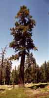
Backpacking Miles The trail South from Carson Pass on the Pacific Crest Trail is the driest terrain we have yet crossed since departing Meeks Bay.
Trails Forum
Check out the |
|||||||||||||||||||||||||||||||||||||||||||||||||||||||||||||||||||||||||||||||||||||||||||||||||||||||||||||||||||||||||||||||||||||||||||||||||||||||||||||||||||||||||||||||||||||||||||||||||||||||||||||||||||||||||||||||||||||||||
MILES
Northeast
Meyers to Meiss Cabin
Miles and Elevations North: Echo Summit to Carson Pass Miles and Elevations South: Ebbetts Pass to Sonora Pass
Note |
This trail guide, like the High Sierras, divides itself into ups and downs. Our miles are generally done either going up to the top of the mountain, or we are coming down from the mountaintop into the valley that separates us from the next mountaintop. There are 27.88 miles between the Carson Pass and the Ebbetts Pass along the Pacific Crest Trail. Ebbetts Pass is 1355 feet higher than the Carson Pass. But these gross elevation and mileage figures do not describe the series of challenging ups and downs that virtually all Sierra trails present to their visitors. We have to climb Forestdale Divide, the Nipple, and Raymond Peak between Carson Pass and Ebbetts Pass. We hike around the base of Reynolds Peak, pretty much, and the final climb up to Ebbetts Pass is gentle. From Carson Pass to Ebbetts Pass the terrain can too be categorized as a roller coaster, but this section of our ride through much more arid conditions than the conditions we experienced in Desolation Wilderness and the Tahoe Basin. Remember this important rule to keep our attitude positive: Get used to it. Accept it. Enjoy it. |
Backpacker Forums Post it on Above we come to the Front Page of the High Backpacking Trails and Topics Forums. Below we break the forums down into categories:
Anyone can post text comments in the existing forums, but only members can post up new topics, along with images, maps, and formatting. If you have experiences, comments, questions, trip reports, corrections, trail conditions updates or pictures and videos of the Pacific Crest Trail from Carson Pass to Ebbetts Pass, post up here as an unknown hiker or as a member. Section
|
MILES
Northeast
Meyers to Meiss Cabin
Miles and Elevations North: Echo Summit to Carson Pass Miles and Elevations South: Ebbetts Pass to Sonora Pass
Trailhead
Contact
Alex Wierbinski